

<< Text Pages >> Belleix Dolmen - Burial Chamber or Dolmen in France in Limousin:Haute-Vienne (87)
Submitted by TheCaptain on Saturday, 16 April 2005 Page Views: 3066
Neolithic and Bronze AgeSite Name: Belleix DolmenCountry: France Département: Limousin:Haute-Vienne (87) Type: Burial Chamber or Dolmen
Nearest Town: Limoges Nearest Village: Blond
Latitude: 46.061000N Longitude: 1.072000E
Condition:
| 5 | Perfect |
| 4 | Almost Perfect |
| 3 | Reasonable but with some damage |
| 2 | Ruined but still recognisable as an ancient site |
| 1 | Pretty much destroyed, possibly visible as crop marks |
| 0 | No data. |
| -1 | Completely destroyed |
| 5 | Superb |
| 4 | Good |
| 3 | Ordinary |
| 2 | Not Good |
| 1 | Awful |
| 0 | No data. |
| 5 | Can be driven to, probably with disabled access |
| 4 | Short walk on a footpath |
| 3 | Requiring a bit more of a walk |
| 2 | A long walk |
| 1 | In the middle of nowhere, a nightmare to find |
| 0 | No data. |
| 5 | co-ordinates taken by GPS or official recorded co-ordinates |
| 4 | co-ordinates scaled from a detailed map |
| 3 | co-ordinates scaled from a bad map |
| 2 | co-ordinates of the nearest village |
| 1 | co-ordinates of the nearest town |
| 0 | no data |
Be the first person to rate this site - see the 'Contribute!' box in the right hand menu.
Internal Links:
External Links:
Dolmen in Haute-Vienne
IMPORTANT NOTE: Site believed to be near this position
You may be viewing yesterday's version of this page. To see the most up to date information please register for a free account.
Do not use the above information on other web sites or publications without permission of the contributor.
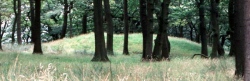
Nearby Images from Flickr
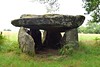
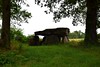
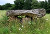
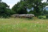
The above images may not be of the site on this page, but were taken nearby. They are loaded from Flickr so please click on them for image credits.
Click here to see more info for this site
Nearby sites
Click here to view sites on an interactive map of the areaKey: Red: member's photo, Blue: 3rd party photo, Yellow: other image, Green: no photo - please go there and take one, Grey: site destroyed
Download sites to:
KML (Google Earth)
GPX (GPS waypoints)
CSV (Garmin/Navman)
CSV (Excel)
To unlock full downloads you need to sign up as a Contributory Member. Otherwise downloads are limited to 50 sites.
Turn off the page maps and other distractions
Nearby sites listing. In the following links * = Image available
1.1km NE 35° La Lue Dolmen* Burial Chamber or Dolmen
1.1km NW 325° Drouilles Dolmen Burial Chamber or Dolmen
1.4km NNE 17° Borderie Dolmen* Burial Chamber or Dolmen
1.7km WNW 295° Dolmen du Cluzeau 2 Burial Chamber or Dolmen
1.7km WNW 295° Dolmen du Cluzeau 1 Burial Chamber or Dolmen
3.3km ESE 111° Betoulle dolmen 1* Burial Chamber or Dolmen
3.3km ESE 112° Betoulle dolmen 2* Burial Chamber or Dolmen
3.3km ESE 113° Betoulle dolmen 4* Burial Chamber or Dolmen
3.3km SE 130° Dolmen du Got Burial Chamber or Dolmen
3.3km ESE 113° Betoulle dolmen 3* Burial Chamber or Dolmen
4.6km WSW 244° Menhir de Ruilleres Standing Stone (Menhir)
4.7km WSW 245° Menhir de Combe Libert Standing Stone (Menhir)
5.4km E 99° Dolmen dit de Taminage* Burial Chamber or Dolmen
5.9km SW 230° Les Rochers de Puychaud* Rock Outcrop
5.9km SW 231° Dolmen de Puychaud* Burial Chamber or Dolmen
6.7km WSW 249° Menhir de Rousseix Standing Stone (Menhir)
8.2km SW 216° Pierre Branlante de Boscartus* Natural Stone / Erratic / Other Natural Feature
9.4km S 190° Dolmen de la Betoulle* Burial Chamber or Dolmen
9.9km ESE 123° Menhir de la Croix Parot* Standing Stone (Menhir)
10.5km SW 216° Grotte dite le Rocher des Fées (Cieux)* Cave or Rock Shelter
10.7km SW 228° Pierre à Sacrifice de Cieux* Rock Outcrop
10.7km NE 54° Dolmen des Mazieres Burial Chamber or Dolmen
10.9km NNW 339° Dolmen de Montaumar* Burial Chamber or Dolmen
11.3km NNW 342° Dolmen du Toury 2 Burial Chamber or Dolmen
11.3km NNW 342° Dolmen du Toury 1 Burial Chamber or Dolmen
View more nearby sites and additional images


 We would like to know more about this location. Please feel free to add a brief description and any relevant information in your own language.
 Wir möchten mehr über diese Stätte erfahren. Bitte zögern Sie nicht, eine kurze Beschreibung und relevante Informationen in Deutsch hinzuzufügen.
 Nous aimerions en savoir encore un peu sur les lieux. S'il vous plaît n'hesitez pas à ajouter une courte description et tous les renseignements pertinents dans votre propre langue.
 Quisieramos informarnos un poco más de las lugares. No dude en añadir una breve descripción y otros datos relevantes en su propio idioma.