
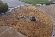

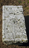
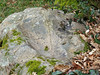
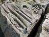
<< Our Photo Pages >> Petit Fontenail polissoir - Polissoir in France in Centre:Loire-et-Cher (41)
Submitted by TheCaptain on Saturday, 16 April 2005 Page Views: 2767
Neolithic and Bronze AgeSite Name: Petit Fontenail polissoirCountry: France Département: Centre:Loire-et-Cher (41) Type: Polissoir
Nearest Town: Vendôme Nearest Village: Nourray
Latitude: 47.717249N Longitude: 1.058829E
Condition:
| 5 | Perfect |
| 4 | Almost Perfect |
| 3 | Reasonable but with some damage |
| 2 | Ruined but still recognisable as an ancient site |
| 1 | Pretty much destroyed, possibly visible as crop marks |
| 0 | No data. |
| -1 | Completely destroyed |
| 5 | Superb |
| 4 | Good |
| 3 | Ordinary |
| 2 | Not Good |
| 1 | Awful |
| 0 | No data. |
| 5 | Can be driven to, probably with disabled access |
| 4 | Short walk on a footpath |
| 3 | Requiring a bit more of a walk |
| 2 | A long walk |
| 1 | In the middle of nowhere, a nightmare to find |
| 0 | No data. |
| 5 | co-ordinates taken by GPS or official recorded co-ordinates |
| 4 | co-ordinates scaled from a detailed map |
| 3 | co-ordinates scaled from a bad map |
| 2 | co-ordinates of the nearest village |
| 1 | co-ordinates of the nearest town |
| 0 | no data |
Internal Links:
External Links:
")
You may be viewing yesterday's version of this page. To see the most up to date information please register for a free account.
")
")
Do not use the above information on other web sites or publications without permission of the contributor.
Nearby Images from Flickr
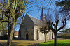
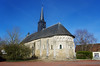
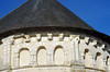
The above images may not be of the site on this page, but were taken nearby. They are loaded from Flickr so please click on them for image credits.
Click here to see more info for this site
Nearby sites
Click here to view sites on an interactive map of the areaKey: Red: member's photo, Blue: 3rd party photo, Yellow: other image, Green: no photo - please go there and take one, Grey: site destroyed
Download sites to:
KML (Google Earth)
GPX (GPS waypoints)
CSV (Garmin/Navman)
CSV (Excel)
To unlock full downloads you need to sign up as a Contributory Member. Otherwise downloads are limited to 50 sites.
Turn off the page maps and other distractions
Nearby sites listing. In the following links * = Image available
30m SSE 155° Dolmen du Plateau de la Petite Beauce Burial Chamber or Dolmen
1.6km WNW 301° Dolmen des Tatonneries Burial Chamber or Dolmen
3.4km WNW 302° Hauts-de-Bretagne Dolmen* Burial Chamber or Dolmen
3.4km WNW 302° Hauts-de-Bretagne Polissoir* Polissoir
3.9km WNW 285° Gâts-Fleuris Dolmen* Burial Chamber or Dolmen
3.9km WNW 286° Menhir des Gâts-Fleuris Standing Stone (Menhir)
4.3km NW 318° Dolmen des Marais de Pouline Burial Chamber or Dolmen
4.8km NW 318° Menhir dit le Coffre Bahut Standing Stone (Menhir)
5.0km NNW 335° Villerable Menhirs Standing Stone (Menhir)
6.0km WNW 299° La Pierre Sorcière* Burial Chamber or Dolmen
6.1km NW 304° Dolmen de la Ferme de la Fontaine Burial Chamber or Dolmen
6.3km NNW 341° Menhir de Chanteloup Standing Stone (Menhir)
7.1km NNW 337° Mondétour polissoirs Polissoir
7.3km N 7° Musée Municipal Museum
7.6km NW 316° Dolmen de Vaugouffard Burial Chamber or Dolmen
7.8km N 8° Menhir du Temple (Vendome) Standing Stone (Menhir)
8.4km NNE 20° Menhir de la Grosse-Haie Standing Stone (Menhir)
8.5km NNE 24° Menhir d'Huchigny Standing Stone (Menhir)
9.9km ENE 61° Dolmen de Cornevache Burial Chamber or Dolmen
10.5km NW 318° Menhir La Pierre Levée Standing Stone (Menhir)
10.9km SE 130° Pierre Levée de la Glandée Burial Chamber or Dolmen
11.7km ESE 123° Dolmen de la Pie Burial Chamber or Dolmen
11.9km ESE 124° Dolmen de la Carrière* Burial Chamber or Dolmen
12.5km ESE 120° Dolmen de Bourges Burial Chamber or Dolmen
14.8km ESE 124° Dolmen de la Fontaine (Russy) Burial Chamber or Dolmen
View more nearby sites and additional images


 We would like to know more about this location. Please feel free to add a brief description and any relevant information in your own language.
 Wir möchten mehr über diese Stätte erfahren. Bitte zögern Sie nicht, eine kurze Beschreibung und relevante Informationen in Deutsch hinzuzufügen.
 Nous aimerions en savoir encore un peu sur les lieux. S'il vous plaît n'hesitez pas à ajouter une courte description et tous les renseignements pertinents dans votre propre langue.
 Quisieramos informarnos un poco más de las lugares. No dude en añadir una breve descripción y otros datos relevantes en su propio idioma.