

<< Our Photo Pages >> Moss Knowes - Natural Stone / Erratic / Other Natural Feature in Scotland in South Ayrshire
Submitted by markj99 on Sunday, 28 May 2023 Page Views: 245
Natural PlacesSite Name: Moss KnowesCountry: Scotland County: South Ayrshire Type: Natural Stone / Erratic / Other Natural Feature
Nearest Town: Dalmellington Nearest Village: Carsphairn
Map Ref: NX42239281
Latitude: 55.204275N Longitude: 4.480718W
Condition:
| 5 | Perfect |
| 4 | Almost Perfect |
| 3 | Reasonable but with some damage |
| 2 | Ruined but still recognisable as an ancient site |
| 1 | Pretty much destroyed, possibly visible as crop marks |
| 0 | No data. |
| -1 | Completely destroyed |
| 5 | Superb |
| 4 | Good |
| 3 | Ordinary |
| 2 | Not Good |
| 1 | Awful |
| 0 | No data. |
| 5 | Can be driven to, probably with disabled access |
| 4 | Short walk on a footpath |
| 3 | Requiring a bit more of a walk |
| 2 | A long walk |
| 1 | In the middle of nowhere, a nightmare to find |
| 0 | No data. |
| 5 | co-ordinates taken by GPS or official recorded co-ordinates |
| 4 | co-ordinates scaled from a detailed map |
| 3 | co-ordinates scaled from a bad map |
| 2 | co-ordinates of the nearest village |
| 1 | co-ordinates of the nearest town |
| 0 | no data |
Internal Links:
External Links:
I have visited· I would like to visit
markj99 visited on 27th May 2023 - their rating: Cond: 4 Amb: 4 Access: 1 On my return to Moss Knowe Rocking Stone, the pine forest had been felled. The stone was now on the edge of a large clearing, still intact.
markj99 visited on 26th Sep 2009 - their rating: Cond: 4 Amb: 4 Access: 1 When I first saw Moss Knowes Rocking Stone it was on the edge of a pine forest on the way to Tunskeen Bothy.
Average ratings for this site from all visit loggers: Condition: 4 Ambience: 4 Access: 1
")
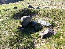
Moss Knowes Rocking Stone is located in South Ayrshire, c. 0.5 mile W of the S end of Loch Ricawr in Galloway Forest Park. It is marked on OS Mapping. The rocking stone is a sub-rectangular stone measuring c. 10 x 5 x 5 feet. The long axis runs E-W. It is balanced on a large wedge-shaped boulder measuring c. 11 feet high by 15 feet wide in the SW side sloping down to 3 feet high in the NE side. A choke stone on the NE slope of the wedge-shaped boulder appears to have wedged the rocking stone in position. As a result, the rocking stone doesn't rock. It is unclear whether the choke stone is natural or a later addition by man.
Moss Knowes Rocking Stone is accessed via Carrick Forest Drive, which is currently closed to vehicles. A mountain bike is the best way to reach the rocking stone from the W terminus of Carrick Forest Drive at NX 41312 95695. Follow the Carrick Forest Drive for c. 1.7 miles to reach a right turn just before Loch Riecawr. Take the right turn heading S for c. 1.1 miles to reach Moss Knowes Rocking Stone. It is c. 25 yards SE of the forest track in an open area of felled forest.
You may be viewing yesterday's version of this page. To see the most up to date information please register for a free account.
")
")
")
")
")
")
")
")
")
Do not use the above information on other web sites or publications without permission of the contributor.
Click here to see more info for this site
Nearby sites
Key: Red: member's photo, Blue: 3rd party photo, Yellow: other image, Green: no photo - please go there and take one, Grey: site destroyed
Download sites to:
KML (Google Earth)
GPX (GPS waypoints)
CSV (Garmin/Navman)
CSV (Excel)
To unlock full downloads you need to sign up as a Contributory Member. Otherwise downloads are limited to 50 sites.
Turn off the page maps and other distractions
Nearby sites listing. In the following links * = Image available
5.5km NNW 338° Cairnwhapple Stone* Natural Stone / Erratic / Other Natural Feature (NX40399796)
8.3km E 99° King's Stone (Carsphairn) Natural Stone / Erratic / Other Natural Feature (NX50419127)
8.3km E 99° King's Well (Carsphairn) Holy Well or Sacred Spring (NX5043591268)
8.4km SSE 168° Grey Man of the Merrick* Natural Stone / Erratic / Other Natural Feature (NX43658450)
8.6km W 279° Bencallen Hill* Chambered Cairn (NX33779440)
8.6km SSW 209° Kirriemore* Chambered Cairn (NX37738544)
8.8km SW 227° Cairnfore* Cairn (NX35548707)
9.7km SSE 157° Devil's Bowling Green* Natural Stone / Erratic / Other Natural Feature (NX45658375)
11.1km NW 312° Knockinculloch* Ancient Village or Settlement (NS34200050)
11.7km NE 45° Cairnennock Cairn (NS50800078)
12.3km SW 221° Sheuchan's Cairn* Chambered Cairn (NX33798387)
12.3km ENE 57° Lamford Burn* Cairn (NX52829916)
13.1km E 82° Holm Of Daltallochan Stone Circle* Stone Circle (NX55289422)
13.2km E 82° Holm of Daltallochan Standing Stone* Standing Stone (Menhir) (NX55399420)
13.6km E 81° Green Well of Scotland (Carsphairn) Holy Well or Sacred Spring (NX5573494565)
13.7km E 89° Cairn Avel* Cairn (NX55949245)
14.7km E 94° Bardennoch* Cairn (NX56859120)
14.9km ESE 109° Physic Well (Kells) Holy Well or Sacred Spring (NX5622587525)
14.9km E 96° Braidenoch Cross Slabs* Early Christian Sculptured Stone (NX57099081)
15.2km NE 56° Brownhill Burn* Cairn (NS55210089)
15.6km NE 56° Water of Deugh* Chambered Cairn (NS55420114)
15.9km SSW 208° Bargrennan Burn White Cairn* Cairn (NX34227910)
16.0km SSW 204° White Cairn, Bargrennan* Chambered Cairn (NX3524378359)
16.7km SW 217° Cairnderry* Chambered Cairn (NX31597993)
17.3km NW 306° Captain's Bridge (Drummochreen) SE* Stone Fort or Dun (NS28530351)
View more nearby sites and additional images


 We would like to know more about this location. Please feel free to add a brief description and any relevant information in your own language.
 Wir möchten mehr über diese Stätte erfahren. Bitte zögern Sie nicht, eine kurze Beschreibung und relevante Informationen in Deutsch hinzuzufügen.
 Nous aimerions en savoir encore un peu sur les lieux. S'il vous plaît n'hesitez pas à ajouter une courte description et tous les renseignements pertinents dans votre propre langue.
 Quisieramos informarnos un poco más de las lugares. No dude en añadir una breve descripción y otros datos relevantes en su propio idioma.