


<< Our Photo Pages >> Robin of Risingham (Woodburn) - Carving in England in Northumberland
Submitted by Anne T on Sunday, 09 July 2017 Page Views: 4175
Multi-periodSite Name: Robin of Risingham (Woodburn)Country: England County: Northumberland Type: Carving
Nearest Town: Bellingham Nearest Village: West Woodburn
Map Ref: NY90148564
Latitude: 55.164977N Longitude: 2.15631W
Condition:
| 5 | Perfect |
| 4 | Almost Perfect |
| 3 | Reasonable but with some damage |
| 2 | Ruined but still recognisable as an ancient site |
| 1 | Pretty much destroyed, possibly visible as crop marks |
| 0 | No data. |
| -1 | Completely destroyed |
| 5 | Superb |
| 4 | Good |
| 3 | Ordinary |
| 2 | Not Good |
| 1 | Awful |
| 0 | No data. |
| 5 | Can be driven to, probably with disabled access |
| 4 | Short walk on a footpath |
| 3 | Requiring a bit more of a walk |
| 2 | A long walk |
| 1 | In the middle of nowhere, a nightmare to find |
| 0 | No data. |
| 5 | co-ordinates taken by GPS or official recorded co-ordinates |
| 4 | co-ordinates scaled from a detailed map |
| 3 | co-ordinates scaled from a bad map |
| 2 | co-ordinates of the nearest village |
| 1 | co-ordinates of the nearest town |
| 0 | no data |
Internal Links:
External Links:
I have visited· I would like to visit
Anne T visited on 8th Jul 2017 - their rating: Cond: 3 Amb: 3 Access: 4 Robin of Risingham, West Woodburn: Our first stop of the day, just south of West Woodburn on the A68. The sun was shining, it was warm and there was barely a breeze apart when the many motorbikes whizzed past at high speed.
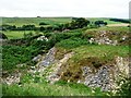
Conveniently, there is a layby next to the start of the footpath leading from the A68 to Parkhead Farm at NY 90466 85463. Letting ourselves in through the gate into the field, the view was picturesque with views across the River Rede Valley to the west and pretty sheep and their large lambs.
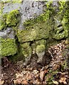
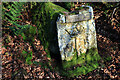
We were keen to see this as the Historic England entry says this is the only known Roman statue carved from rock in Northumberland.
Making our way to the southern edge of the farm, there was a track leading through the field just to its east, just above their driveway. Following this to the end of the field, there was no way out – no stile, no sign, nothing. We retraced our steps and tried to find a different way past the farm buildings and ended up in a barn with some wonderful horses. In the end, we let ourselves into the farmyard and walked down the driveway, hoping to come across someone so we could ask where the proper path was.
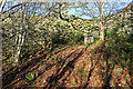
There are some 3 to 4 houses along your left hand side here. Walking past the last one, Robin can be found about 100 metres further along the driveway. Husband Andrew then headed up the short tree covered slope to the wall separating the farm drive from the quarries above and found the carving hidden amongst the trees.
The dappled sunlight coming through the trees made this tricky to photograph. All the literature we’ve read said only the legs remain. We hunted for ages to see if they were on the rock behind the modern replica, or on the surrounding stone walls.
The intention later was to find the Roman Tombs on Otterburn Ranges which weren’t being used for military training this weekend, but we spent so long on other sites that we left this for another day.
 (PID:167674)")
Marked on the OS map as being just north west of Parkhead Farm, this figure cut in relief dates from the Roman period. Recorded as Pastscape Monument No. 19329, which records this as a "Roman rock carving, probably of a hunting diety, mutilated in the 19th century" and is the only known Roman statue in Northumberland carved from a rock outcrop.
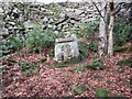
Historic England have scheduled this as List Entry 1012133 which adds: "The monument consists of the lower half of a figure cut in relief on a rock outcrop. It is located in an alcove formed by a retaining wall on a steep incline immediately below a south-westerly spread of spoil from Woodburn Quarries. The carving, which has been identified as a native hunting god, was recorded in the early 18th century by Horsley and other antiquarians before being partially destroyed by the then landowner who thereby attempted to stop people wishing to view it from trespassing on his lands. Originally the figure stood 4ft high and had a panel, perhaps for an inscription, above his head. The god holds a bow and a small animal, possibly a hare, in his hands, and is dressed in a tunic and cloak, with a square block or altar opposite his right knee. A half size replica of the original was erected adjacent to the parent rock by the Redesdale Society in 1983."
To access the carving we parked in a layby at NY 90466 85463 and walked down the footpath from the A68, leading north west towards Parkhead Farm. Near the farm buildngs the footpath seems to have been either diverted or destroyed. We ended up letting ourselves into the driveway of the houses and walking down the lane. The carving is about 100 metres from the northern-most building and up a bank of young trees to a dry stone walled niche at the base of a quarry heap.
You may be viewing yesterday's version of this page. To see the most up to date information please register for a free account.
 (PID:167675)")
Do not use the above information on other web sites or publications without permission of the contributor.
Nearby Images from Geograph Britain and Ireland:
©2020(licence)
©2023(licence)
©2022(licence)
©2020(licence)
©2010(licence)
The above images may not be of the site on this page, they are loaded from Geograph.
Please Submit an Image of this site or go out and take one for us!
Click here to see more info for this site
Nearby sites
Key: Red: member's photo, Blue: 3rd party photo, Yellow: other image, Green: no photo - please go there and take one, Grey: site destroyed
Download sites to:
KML (Google Earth)
GPX (GPS waypoints)
CSV (Garmin/Navman)
CSV (Excel)
To unlock full downloads you need to sign up as a Contributory Member. Otherwise downloads are limited to 50 sites.
Turn off the page maps and other distractions
Nearby sites listing. In the following links * = Image available
1.6km NE 39° Woodburnhill (East Woodburn)* Ancient Cross (NY9114486888)
2.4km NNW 329° Woodhouse (West Woodburn)* Cairn (NY8888187732)
3.8km NNW 343° St Cuthbert's Church (Corsenside)* Ancient Cross (NY8902089266)
4.1km WSW 240° Rede Settlement Ancient Village or Settlement (NY866836)
4.5km SSW 209° Budeland Settlement Ancient Village or Settlement (NY879817)
5.0km S 188° Lowshield Green Cairn* Cairn (NY89448066)
5.1km SW 230° Redesmouth Settlement Ancient Village or Settlement (NY862824)
5.2km ESE 102° Ray-Sunniside i Rock Art (NY9521684589)
5.6km E 99° Ray-Sunniside l Rock Art (NY9566584792)
5.6km S 172° Tone Hall Earthwork Misc. Earthwork (NY909801)
5.6km E 99° Ray-Sunniside a Rock Art (NY9568784785)
5.6km SSW 209° High Countess Park Settlement Ancient Village or Settlement (NY874807)
5.7km E 97° Ray-Sunniside k Rock Art (NY9580084950)
5.7km E 97° Ray Burn Enclosure 1 Rock Art (NY95808490)
5.7km E 98° Ray-Sunniside m Rock Art (NY9583284871)
5.7km E 96° Ray-Sunniside c Rock Art (NY9586484980)
5.8km E 96° Ray-Sunniside e Rock Art (NY9589985021)
5.8km E 96° Ray-Sunniside d Rock Art (NY9591084995)
5.8km E 96° Ray-Sunniside f Rock Art (NY9592984983)
5.8km E 96° Ray-Sunniside j Rock Art (NY9593785005)
5.9km E 96° Ray-Sunniside g Rock Art (NY9602385041)
5.9km E 96° Ray-Sunniside b Rock Art (NY9606085040)
5.9km E 96° Ray-Sunniside h Rock Art (NY9606585042)
6.0km SSW 192° Lowshield Green Cairn 2* Cairn (NY88877974)
6.1km SW 229° Whitewall Nook Enclosure Ancient Village or Settlement (NY855816)
View more nearby sites and additional images


 We would like to know more about this location. Please feel free to add a brief description and any relevant information in your own language.
 Wir möchten mehr über diese Stätte erfahren. Bitte zögern Sie nicht, eine kurze Beschreibung und relevante Informationen in Deutsch hinzuzufügen.
 Nous aimerions en savoir encore un peu sur les lieux. S'il vous plaît n'hesitez pas à ajouter une courte description et tous les renseignements pertinents dans votre propre langue.
 Quisieramos informarnos un poco más de las lugares. No dude en añadir una breve descripción y otros datos relevantes en su propio idioma.