


<< Our Photo Pages >> Menhir de Bignon 2 - Standing Stone (Menhir) in France in Bretagne:Morbihan (56)
Submitted by regina on Monday, 09 January 2017 Page Views: 1026
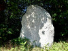
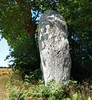
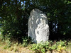
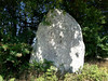
Neolithic and Bronze AgeSite Name: Menhir de Bignon 2Country: France Département: Bretagne:Morbihan (56) Type: Standing Stone (Menhir)
Nearest Town: Vannes Nearest Village: Saint-Guyomard
Latitude: 47.770700N Longitude: 2.48606W
Condition:
| 5 | Perfect |
| 4 | Almost Perfect |
| 3 | Reasonable but with some damage |
| 2 | Ruined but still recognisable as an ancient site |
| 1 | Pretty much destroyed, possibly visible as crop marks |
| 0 | No data. |
| -1 | Completely destroyed |
| 5 | Superb |
| 4 | Good |
| 3 | Ordinary |
| 2 | Not Good |
| 1 | Awful |
| 0 | No data. |
| 5 | Can be driven to, probably with disabled access |
| 4 | Short walk on a footpath |
| 3 | Requiring a bit more of a walk |
| 2 | A long walk |
| 1 | In the middle of nowhere, a nightmare to find |
| 0 | No data. |
| 5 | co-ordinates taken by GPS or official recorded co-ordinates |
| 4 | co-ordinates scaled from a detailed map |
| 3 | co-ordinates scaled from a bad map |
| 2 | co-ordinates of the nearest village |
| 1 | co-ordinates of the nearest town |
| 0 | no data |
Internal Links:
External Links:
I have visited· I would like to visit
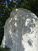
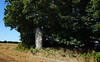
aolson visited on 19th Jul 2020 - their rating: Cond: 4 Amb: 3 Access: 5 There was an old sign nailed to a nearby tree that shows that at one time this area was cleared ant labeled, but today the sign is weathered to bare wood, and the stone is surrounded by brush.
")
Difficult to see how big because of all the bushes.
You may be viewing yesterday's version of this page. To see the most up to date information please register for a free account.
")
")
Do not use the above information on other web sites or publications without permission of the contributor.
Nearby Images from Flickr
The above images may not be of the site on this page, but were taken nearby. They are loaded from Flickr so please click on them for image credits.
Click here to see more info for this site
Nearby sites
Click here to view sites on an interactive map of the areaKey: Red: member's photo, Blue: 3rd party photo, Yellow: other image, Green: no photo - please go there and take one, Grey: site destroyed
Download sites to:
KML (Google Earth)
GPX (GPS waypoints)
CSV (Garmin/Navman)
CSV (Excel)
To unlock full downloads you need to sign up as a Contributory Member. Otherwise downloads are limited to 50 sites.
Turn off the page maps and other distractions
Nearby sites listing. In the following links * = Image available
511m NNW 344° Menhir Le Bignon* Standing Stone (Menhir)
800m NNW 348° Allée couverte du Bignon* Passage Grave
939m SSE 151° Pierre Longue (Molac)* Standing Stone (Menhir)
1.7km NW 312° Menhir dit la Pierre Droite (Saint-Guyomard)* Standing Stone (Menhir)
2.2km W 262° Menhir de La Noë Standing Stone (Menhir)
2.6km W 273° Allée couvert Les Bellans* Passage Grave
2.7km WSW 242° Dolmen du Batiment de la Foret Burial Chamber or Dolmen
2.7km WSW 238° Dolmen de la Maison de la Forêt Burial Chamber or Dolmen
3.1km WNW 287° Le Passoir Menhir* Standing Stone (Menhir)
3.2km WSW 258° Dolmen de la Forêt de Molac 1 Burial Chamber or Dolmen
3.3km WSW 256° Allée Couverte de la Forêt de Molac Passage Grave
3.4km WSW 258° Menhir de la Forêt de Molac 1 Standing Stone (Menhir)
3.4km W 264° Menhir de la Forêt de Molac 2 Standing Stone (Menhir)
3.5km ENE 60° Allée Couverte de Trébiguet Passage Grave
3.5km WNW 282° Menhirs de Belle Alouette* Standing Stones
3.5km WSW 255° Dolmen de la Forêt de Molac 2 Burial Chamber or Dolmen
3.5km WSW 251° Dolmen de la Forêt de Molac 3 Burial Chamber or Dolmen
3.6km W 267° Dolmen de Coëby 1* Burial Chamber or Dolmen
3.6km WSW 252° Menhir de la Forêt de Molac 3 Standing Stone (Menhir)
3.7km WSW 251° Menhir de la Forêt de Molac 4 Standing Stone (Menhir)
4.0km SW 222° Menhir de Clos Bono* Standing Stone (Menhir)
4.0km W 265° Dolmen de Coëby 4 Burial Chamber or Dolmen
4.0km W 265° Dolmen de Coëby 3 Burial Chamber or Dolmen
4.0km WNW 299° Menhir Fourchu* Standing Stone (Menhir)
4.0km W 269° Dolmen de Coëby 5 Burial Chamber or Dolmen
View more nearby sites and additional images


 We would like to know more about this location. Please feel free to add a brief description and any relevant information in your own language.
 Wir möchten mehr über diese Stätte erfahren. Bitte zögern Sie nicht, eine kurze Beschreibung und relevante Informationen in Deutsch hinzuzufügen.
 Nous aimerions en savoir encore un peu sur les lieux. S'il vous plaît n'hesitez pas à ajouter une courte description et tous les renseignements pertinents dans votre propre langue.
 Quisieramos informarnos un poco más de las lugares. No dude en añadir una breve descripción y otros datos relevantes en su propio idioma.