

<< Our Photo Pages >> Menhir de Kraudy - Standing Stone (Menhir) in France in Bretagne:Côtes-D'Armor (22)
Submitted by johnstone on Monday, 25 July 2016 Page Views: 1711
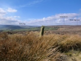
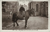
Neolithic and Bronze AgeSite Name: Menhir de Kraudy Alternative Name: Keraudy, KerodyCountry: France Département: Bretagne:Côtes-D'Armor (22) Type: Standing Stone (Menhir)
Nearest Town: Guingamp Nearest Village: Saint-Nicolas-du-Pélem
Latitude: 48.328440N Longitude: 3.15694W
Condition:
| 5 | Perfect |
| 4 | Almost Perfect |
| 3 | Reasonable but with some damage |
| 2 | Ruined but still recognisable as an ancient site |
| 1 | Pretty much destroyed, possibly visible as crop marks |
| 0 | No data. |
| -1 | Completely destroyed |
| 5 | Superb |
| 4 | Good |
| 3 | Ordinary |
| 2 | Not Good |
| 1 | Awful |
| 0 | No data. |
| 5 | Can be driven to, probably with disabled access |
| 4 | Short walk on a footpath |
| 3 | Requiring a bit more of a walk |
| 2 | A long walk |
| 1 | In the middle of nowhere, a nightmare to find |
| 0 | No data. |
| 5 | co-ordinates taken by GPS or official recorded co-ordinates |
| 4 | co-ordinates scaled from a detailed map |
| 3 | co-ordinates scaled from a bad map |
| 2 | co-ordinates of the nearest village |
| 1 | co-ordinates of the nearest town |
| 0 | no data |
Internal Links:
External Links:
I have visited· I would like to visit
johnstone visited on 21st Jun 2023 - their rating: Cond: 4 Amb: 4 Access: 4
")
Milin Coz Salon, Saint-Nicolas-du-Pélem, Guingamp, Côtes-d'Armor, Brittany
Information and Pictures:
t4t35.fr
You may be viewing yesterday's version of this page. To see the most up to date information please register for a free account.
")
")
")
Do not use the above information on other web sites or publications without permission of the contributor.
Nearby Images from Flickr


The above images may not be of the site on this page, but were taken nearby. They are loaded from Flickr so please click on them for image credits.
Click here to see more info for this site
Nearby sites
Click here to view sites on an interactive map of the areaKey: Red: member's photo, Blue: 3rd party photo, Yellow: other image, Green: no photo - please go there and take one, Grey: site destroyed
Download sites to:
KML (Google Earth)
GPX (GPS waypoints)
CSV (Garmin/Navman)
CSV (Excel)
To unlock full downloads you need to sign up as a Contributory Member. Otherwise downloads are limited to 50 sites.
Turn off the page maps and other distractions
Nearby sites listing. In the following links * = Image available
823m SSW 207° Coat Castel Menhir* Standing Stone (Menhir)
932m ESE 121° Menhir de Dzillou Standing Stone (Menhir)
6.3km NW 318° Menhir de Kerlagadec* Standing Stone (Menhir)
7.2km NE 39° The two Wells of the Light* Holy Well or Sacred Spring
7.6km ENE 64° Menhir de Goresto* Standing Stone (Menhir)
7.7km NE 54° Menhir de Kergornec* Standing Stone (Menhir)
7.8km WNW 281° Lampaul Huellan* Standing Stones
8.0km NNE 24° Lesquiolec Standing Stone (Menhir)
8.0km NE 54° Menhir dit le Pâtre* Standing Stone (Menhir)
8.0km NW 315° Menhir de Leur Min* Standing Stone (Menhir)
8.0km NW 313° Menhir de Guer An Moch Standing Stone (Menhir)
8.1km NNW 343° St Gildas Well (Magoar)* Holy Well or Sacred Spring
8.2km W 271° Pierre de Tremargat* Rock Outcrop
8.2km W 270° Menhir de Parc-ar-Menhir Standing Stone (Menhir)
8.3km NW 321° Menhir de Kerbalenou* Standing Stone (Menhir)
8.3km NNW 329° Menhir de Kerien Standing Stone (Menhir)
8.4km ENE 65° Menhir de Bodquelen* Standing Stone (Menhir)
8.5km WNW 287° Kerguen 2 Standing Stone (Menhir)
8.6km WNW 290° Menhir de Kerguen 1 Standing Stone (Menhir)
8.7km NNW 332° Menhir de Kerohou Vraz Standing Stone (Menhir)
9.2km NNW 329° Menhir de Crech Quenez Bras* Standing Stone (Menhir)
9.4km N 6° Dolmen de Keranquéré* Burial Chamber or Dolmen
9.6km SSE 160° Menhir de la Chapelle Saint-Gildas* Standing Stone (Menhir)
9.8km SSE 161° St Gildas Well (Laniscat)* Holy Well or Sacred Spring
9.9km NE 50° Cre'h Ogel menhir* Standing Stone (Menhir)
View more nearby sites and additional images


 We would like to know more about this location. Please feel free to add a brief description and any relevant information in your own language.
 Wir möchten mehr über diese Stätte erfahren. Bitte zögern Sie nicht, eine kurze Beschreibung und relevante Informationen in Deutsch hinzuzufügen.
 Nous aimerions en savoir encore un peu sur les lieux. S'il vous plaît n'hesitez pas à ajouter une courte description et tous les renseignements pertinents dans votre propre langue.
 Quisieramos informarnos un poco más de las lugares. No dude en añadir una breve descripción y otros datos relevantes en su propio idioma.