


<< Text Pages >> Menhir de la Grée (Guérande) - Standing Stone (Menhir) in France in Pays de la Loire:Loire-Atlantique
Submitted by holger_rix on Sunday, 03 July 2016 Page Views: 942
Neolithic and Bronze AgeSite Name: Menhir de la Grée (Guérande)Country: France Département: Pays de la Loire:Loire-Atlantique Type: Standing Stone (Menhir)
Nearest Town: Saint-Nazaire Nearest Village: Guérande
Latitude: 47.351528N Longitude: 2.33425W
Condition:
| 5 | Perfect |
| 4 | Almost Perfect |
| 3 | Reasonable but with some damage |
| 2 | Ruined but still recognisable as an ancient site |
| 1 | Pretty much destroyed, possibly visible as crop marks |
| 0 | No data. |
| -1 | Completely destroyed |
| 5 | Superb |
| 4 | Good |
| 3 | Ordinary |
| 2 | Not Good |
| 1 | Awful |
| 0 | No data. |
| 5 | Can be driven to, probably with disabled access |
| 4 | Short walk on a footpath |
| 3 | Requiring a bit more of a walk |
| 2 | A long walk |
| 1 | In the middle of nowhere, a nightmare to find |
| 0 | No data. |
| 5 | co-ordinates taken by GPS or official recorded co-ordinates |
| 4 | co-ordinates scaled from a detailed map |
| 3 | co-ordinates scaled from a bad map |
| 2 | co-ordinates of the nearest village |
| 1 | co-ordinates of the nearest town |
| 0 | no data |
Be the first person to rate this site - see the 'Contribute!' box in the right hand menu.
Internal Links:
External Links:
Standing Stone (Menhir) in Pays de la Loire:Loire-Atlantique
Guérande, Saint-Nazaire, Loire-Atlantique, Pays-de-la-Loire
Source: T4T35
Information and Pictures:
t4t35.fr
You may be viewing yesterday's version of this page. To see the most up to date information please register for a free account.
Do not use the above information on other web sites or publications without permission of the contributor.
Nearby Images from Flickr
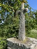
The above images may not be of the site on this page, but were taken nearby. They are loaded from Flickr so please click on them for image credits.
Click here to see more info for this site
Nearby sites
Click here to view sites on an interactive map of the areaKey: Red: member's photo, Blue: 3rd party photo, Yellow: other image, Green: no photo - please go there and take one, Grey: site destroyed
Download sites to:
KML (Google Earth)
GPX (GPS waypoints)
CSV (Garmin/Navman)
CSV (Excel)
To unlock full downloads you need to sign up as a Contributory Member. Otherwise downloads are limited to 50 sites.
Turn off the page maps and other distractions
Nearby sites listing. In the following links * = Image available
644m WSW 248° Croix de Sandun Dolmen* Burial Chamber or Dolmen
989m W 261° Tertre de Bretineau* Long Barrow
1.7km N 356° Rocher Du Rohain* Rock Outcrop
1.8km NNW 341° Dolmens de Crugo Burial Chamber or Dolmen
2.0km N 350° Kerdanestre Menhir Christianisé* Standing Stone (Menhir)
2.4km WSW 259° Dolmen de Lévérac Burial Chamber or Dolmen
2.4km WNW 300° Kerbourg Dolmen 2* Burial Chamber or Dolmen
2.4km WNW 302° Kerbourg Dolmen 1* Passage Grave
2.9km N 351° Keralio Croix Menhir* Standing Stone (Menhir)
3.1km WSW 245° L'Ile de la Chapelle Menhir Standing Stone (Menhir)
3.1km NW 319° Pont de Gras* Ancient Trackway
3.1km WNW 296° La Pierre Blanche (Kerbourg)* Standing Stone (Menhir)
3.2km NE 40° Dolmens dit les Roches de Baudin Burial Chamber or Dolmen
4.6km SSW 198° La Grée Dolmen Burial Chamber or Dolmen
4.8km S 187° Allée Couverte de Coëtcas Passage Grave
4.9km S 187° Menhir de Couëtcas* Standing Stone (Menhir)
5.0km N 357° La Pierre De Len Menhir* Standing Stone (Menhir)
5.9km SW 228° Menhir de Bissin* Standing Stone (Menhir)
6.0km SE 124° Dolmen de la Garenne (St Andre)* Burial Chamber or Dolmen
6.5km NE 48° la Butte-aux-Pierres Not Known (by us)
6.9km NE 43° Dolmen de la Roche au Moine Burial Chamber or Dolmen
7.3km SW 221° Dolmen de Careil Burial Chamber or Dolmen
7.9km SE 126° Dolmen de Cuneix Burial Chamber or Dolmen
8.5km ESE 119° Menhir de la Pierre Blanche (Aucard)* Standing Stone (Menhir)
8.6km WSW 237° La Pierre de Saillé* Standing Stone (Menhir)
View more nearby sites and additional images


 We would like to know more about this location. Please feel free to add a brief description and any relevant information in your own language.
 Wir möchten mehr über diese Stätte erfahren. Bitte zögern Sie nicht, eine kurze Beschreibung und relevante Informationen in Deutsch hinzuzufügen.
 Nous aimerions en savoir encore un peu sur les lieux. S'il vous plaît n'hesitez pas à ajouter une courte description et tous les renseignements pertinents dans votre propre langue.
 Quisieramos informarnos un poco más de las lugares. No dude en añadir una breve descripción y otros datos relevantes en su propio idioma.