


<< Text Pages >> Alignement de Lostmarc'h 2 - Stone Row / Alignment in France in Bretagne:Finistère (29)
Submitted by holger_rix on Thursday, 19 May 2016 Page Views: 911
Neolithic and Bronze AgeSite Name: Alignement de Lostmarc'h 2Country: France Département: Bretagne:Finistère (29) Type: Stone Row / Alignment
Nearest Town: Châteaulin Nearest Village: Crozon
Latitude: 48.218532N Longitude: 4.549027W
Condition:
| 5 | Perfect |
| 4 | Almost Perfect |
| 3 | Reasonable but with some damage |
| 2 | Ruined but still recognisable as an ancient site |
| 1 | Pretty much destroyed, possibly visible as crop marks |
| 0 | No data. |
| -1 | Completely destroyed |
| 5 | Superb |
| 4 | Good |
| 3 | Ordinary |
| 2 | Not Good |
| 1 | Awful |
| 0 | No data. |
| 5 | Can be driven to, probably with disabled access |
| 4 | Short walk on a footpath |
| 3 | Requiring a bit more of a walk |
| 2 | A long walk |
| 1 | In the middle of nowhere, a nightmare to find |
| 0 | No data. |
| 5 | co-ordinates taken by GPS or official recorded co-ordinates |
| 4 | co-ordinates scaled from a detailed map |
| 3 | co-ordinates scaled from a bad map |
| 2 | co-ordinates of the nearest village |
| 1 | co-ordinates of the nearest town |
| 0 | no data |
Be the first person to rate this site - see the 'Contribute!' box in the right hand menu.
Internal Links:
External Links:
Stone Row / Alignment in Bretagne:Finistère (29)
Voie de Morgat à Lostmac'h, Crozon, Châteaulin, Finistère, Brittany
Source: T4T35
Information and Pictures:
t4t35.fr
You may be viewing yesterday's version of this page. To see the most up to date information please register for a free account.
Do not use the above information on other web sites or publications without permission of the contributor.
Nearby Images from Flickr
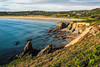


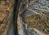
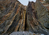
The above images may not be of the site on this page, but were taken nearby. They are loaded from Flickr so please click on them for image credits.
Click here to see more info for this site
Nearby sites
Click here to view sites on an interactive map of the areaKey: Red: member's photo, Blue: 3rd party photo, Yellow: other image, Green: no photo - please go there and take one, Grey: site destroyed
Download sites to:
KML (Google Earth)
GPX (GPS waypoints)
CSV (Garmin/Navman)
CSV (Excel)
To unlock full downloads you need to sign up as a Contributory Member. Otherwise downloads are limited to 50 sites.
Turn off the page maps and other distractions
Nearby sites listing. In the following links * = Image available
414m WSW 239° Alignement de Lostmarc'h 1* Stone Row / Alignment
438m WSW 237° Lostmarc'h menhir* Standing Stone (Menhir)
690m NE 52° Menhir de Kerellot 1 Standing Stone (Menhir)
733m NE 47° Menhir de Kerellot 2 Standing Stone (Menhir)
838m SW 223° Oppidum de la Pointe de Lostmarc'h* Promontory Fort / Cliff Castle
877m SW 222° Dolmen de la Pointe de Lost Marc'h* Chambered Cairn
1.3km NE 40° Dolmen de Tromel Burial Chamber or Dolmen
1.4km SSW 195° Kastell Inizig Promontory Fort / Cliff Castle
1.6km NNE 22° Dolmen de an Drustel Burial Chamber or Dolmen
2.0km NW 323° Alignement de la Pointe de Dinan Stone Row / Alignment
2.1km NW 321° Dolmen de la Pointe de Dinan* Burial Chamber or Dolmen
2.1km S 170° Dolmen de Kerdreux* Burial Chamber or Dolmen
2.2km SSE 167° Menhir de Kerdreux Standing Stone (Menhir)
2.6km NE 45° Menhir de Belbeoch Standing Stone (Menhir)
2.7km NNE 16° Menhir de Goulien Standing Stone (Menhir)
2.7km ESE 103° Alignements de Ty-ar-C'huré* Stone Row / Alignment
3.0km S 174° Menhir dit Ar Men Vras Zalous Standing Stone (Menhir)
3.0km S 179° Alignement de Menesguen Stone Row / Alignment
3.3km S 180° Dolmen de Persig Burial Chamber or Dolmen
3.8km SSE 165° Dolmen de Rostudel* Burial Chamber or Dolmen
4.7km NE 47° Menhir de Crozon Standing Stone (Menhir)
4.9km NE 55° Menhir dit Pierre du Cerceuil Standing Stone (Menhir)
5.1km ENE 59° Menhir ar Men Bris Standing Stone (Menhir)
5.7km ENE 69° La Républicaine* Standing Stone (Menhir)
5.8km NW 325° Quadrilatère de Pen ar Yeun* Stone Circle
View more nearby sites and additional images


 We would like to know more about this location. Please feel free to add a brief description and any relevant information in your own language.
 Wir möchten mehr über diese Stätte erfahren. Bitte zögern Sie nicht, eine kurze Beschreibung und relevante Informationen in Deutsch hinzuzufügen.
 Nous aimerions en savoir encore un peu sur les lieux. S'il vous plaît n'hesitez pas à ajouter une courte description et tous les renseignements pertinents dans votre propre langue.
 Quisieramos informarnos un poco más de las lugares. No dude en añadir una breve descripción y otros datos relevantes en su propio idioma.