


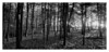
<< Text Pages >> Alignement de la Lande du Cerf - Stone Row / Alignment in France in Bretagne:Morbihan (56)
Submitted by holger_rix on Wednesday, 18 May 2016 Page Views: 1277
Neolithic and Bronze AgeSite Name: Alignement de la Lande du CerfCountry: France Département: Bretagne:Morbihan (56) Type: Stone Row / Alignment
Nearest Town: Pontivy Nearest Village: Cléguérec
Latitude: 48.163929N Longitude: 3.06442W
Condition:
| 5 | Perfect |
| 4 | Almost Perfect |
| 3 | Reasonable but with some damage |
| 2 | Ruined but still recognisable as an ancient site |
| 1 | Pretty much destroyed, possibly visible as crop marks |
| 0 | No data. |
| -1 | Completely destroyed |
| 5 | Superb |
| 4 | Good |
| 3 | Ordinary |
| 2 | Not Good |
| 1 | Awful |
| 0 | No data. |
| 5 | Can be driven to, probably with disabled access |
| 4 | Short walk on a footpath |
| 3 | Requiring a bit more of a walk |
| 2 | A long walk |
| 1 | In the middle of nowhere, a nightmare to find |
| 0 | No data. |
| 5 | co-ordinates taken by GPS or official recorded co-ordinates |
| 4 | co-ordinates scaled from a detailed map |
| 3 | co-ordinates scaled from a bad map |
| 2 | co-ordinates of the nearest village |
| 1 | co-ordinates of the nearest town |
| 0 | no data |
Be the first person to rate this site - see the 'Contribute!' box in the right hand menu.
Internal Links:
External Links:
Stone Row / Alignment in Bretagne:Morbihan (56)
Cléguérec, Pontivy, Morbihan, Brittany
Source: T4T35
You may be viewing yesterday's version of this page. To see the most up to date information please register for a free account.
Do not use the above information on other web sites or publications without permission of the contributor.
Nearby Images from Flickr
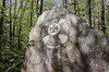
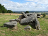
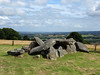
The above images may not be of the site on this page, but were taken nearby. They are loaded from Flickr so please click on them for image credits.
Click here to see more info for this site
Nearby sites
Click here to view sites on an interactive map of the areaKey: Red: member's photo, Blue: 3rd party photo, Yellow: other image, Green: no photo - please go there and take one, Grey: site destroyed
Download sites to:
KML (Google Earth)
GPX (GPS waypoints)
CSV (Garmin/Navman)
CSV (Excel)
To unlock full downloads you need to sign up as a Contributory Member. Otherwise downloads are limited to 50 sites.
Turn off the page maps and other distractions
Nearby sites listing. In the following links * = Image available
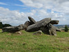
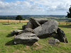
312m SSE 154° Bod er Mohet Allée Couverte* Passage Grave
609m WNW 291° Bugul er Hoët Menhir* Standing Stone (Menhir)
665m SSW 202° Bugul-er-Hoet* Standing Stone (Menhir)
1.4km NW 325° Pierre de Guergadic* Standing Stone (Menhir)
1.4km W 261° Menhir du Breuil-du-Chêne 1 Standing Stone (Menhir)
1.5km W 275° Menhir du Breuil-du-Chêne 4 Standing Stone (Menhir)
1.5km WSW 241° Menhir du Breuil-du-Chêne 3 Standing Stone (Menhir)
1.5km W 259° Menhir du Breuil-du-Chêne 2 Standing Stone (Menhir)
2.6km SW 235° Allée Couverte de Park-er-Bé Passage Grave
3.0km WSW 252° Allée Couverte de Toulhardi Passage Grave
4.5km NE 41° Camp dit du Castel-Finans Ancient Village or Settlement
4.9km WSW 248° Allée Couverte du Grand Boduic Passage Grave
7.3km ENE 71° Menhir de Botconnaire Standing Stone (Menhir)
7.4km NNE 27° Coët Correc allée couverte* Passage Grave
7.7km NNE 21° Ty-Min menhir* Standing Stone (Menhir)
7.8km NNE 23° Porz Guillo menhir* Standing Stone (Menhir)
7.9km NW 323° Liscuis 1 allée couverte* Passage Grave
7.9km NW 323° Liscuis 3 allée couverte* Passage Grave
8.0km NW 323° Liscuis 2 allée couverte* Passage Grave
8.1km NNE 31° Allée couverte de Corn-er-Houët* Passage Grave
8.2km NNW 327° Menhirs de Canac'h Léron* Standing Stones
9.3km N 7° Allée Couverte de Crampoazic Passage Grave
9.5km NW 304° Bochacoat allée couverte* Passage Grave
9.7km NNW 338° St Gildas Well (Laniscat)* Holy Well or Sacred Spring
9.8km S 190° Saint Nizon allée couverte* Burial Chamber or Dolmen
View more nearby sites and additional images


 We would like to know more about this location. Please feel free to add a brief description and any relevant information in your own language.
 Wir möchten mehr über diese Stätte erfahren. Bitte zögern Sie nicht, eine kurze Beschreibung und relevante Informationen in Deutsch hinzuzufügen.
 Nous aimerions en savoir encore un peu sur les lieux. S'il vous plaît n'hesitez pas à ajouter une courte description et tous les renseignements pertinents dans votre propre langue.
 Quisieramos informarnos un poco más de las lugares. No dude en añadir una breve descripción y otros datos relevantes en su propio idioma.