

<< Our Photo Pages >> Merrivale 5 - Stone Row / Alignment in England in Devon
Submitted by Anne T on Tuesday, 03 May 2016 Page Views: 2343
Neolithic and Bronze AgeSite Name: Merrivale 5Country: England County: Devon Type: Stone Row / Alignment
Nearest Town: Tavistock Nearest Village: Merrivale
Map Ref: SX5534974592
Latitude: 50.553142N Longitude: 4.04328W
Condition:
| 5 | Perfect |
| 4 | Almost Perfect |
| 3 | Reasonable but with some damage |
| 2 | Ruined but still recognisable as an ancient site |
| 1 | Pretty much destroyed, possibly visible as crop marks |
| 0 | No data. |
| -1 | Completely destroyed |
| 5 | Superb |
| 4 | Good |
| 3 | Ordinary |
| 2 | Not Good |
| 1 | Awful |
| 0 | No data. |
| 5 | Can be driven to, probably with disabled access |
| 4 | Short walk on a footpath |
| 3 | Requiring a bit more of a walk |
| 2 | A long walk |
| 1 | In the middle of nowhere, a nightmare to find |
| 0 | No data. |
| 5 | co-ordinates taken by GPS or official recorded co-ordinates |
| 4 | co-ordinates scaled from a detailed map |
| 3 | co-ordinates scaled from a bad map |
| 2 | co-ordinates of the nearest village |
| 1 | co-ordinates of the nearest town |
| 0 | no data |
Internal Links:
External Links:
I have visited· I would like to visit
lucasn visited on 27th Jun 2019 - their rating: Cond: 4 Amb: 4 Access: 4
Anne T visited on 14th May 2019 - their rating: Cond: 2 Amb: 3 Access: 4 Merrivale 5 stone row: I was getting really 'dazed and confused' about the different stone rows here and what I was photographing, so I asked Sandy, Dave and Andrew to each place a foot on or near each stone of this row!
Richard13 visited on 1st Jul 2018 - their rating: Cond: 3 Amb: 4 Access: 3
markj99 visited on 28th Nov 2017 - their rating: Cond: 3 Amb: 4 Access: 3 I have visited here, but I was hypnotised by the tall Standing Stone. I failed to notice the alignment of smaller stones.
SandyG visited on 19th Oct 2014 - their rating: Cond: 2 Amb: 5 Access: 4 Car parking is available at SX 55313 75017 or SX 56050 74895. The row is a relatively short walk away from either car park. It is worth having a look at the stone circle a short distance to the north of the row. The row is easiest found by walking towards the large standing stone situated close by.
Average ratings for this site from all visit loggers: Condition: 2.8 Ambience: 4 Access: 3.6
")
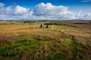
This is one of 6 stone rows/alignments which lie in close proximity to each other in a landscape of stone alignments, plus cairns, cists, a stone circle, standing stones, prehistoric settlement and reave.
Comprising 3 small stones in an alignment of length 5.6 metres, the site has a view of the sea and sits at an altitude of 330 metres. The lower end is made up of a pillar.
Sitting in the Dartmoor National Park Merivale 5 is part of a scheduled ancient monument. This site and its context are described as part of the scheduling information for Historic England List ID 1013430. The site is described as sitting on a gentle south facing slope on Longash Common overlooking the valley of an unnamed tributary of the River Walkham.
This stone row is also recorded as part of the entry for Pastscape Monument No. 440047, which adds: "Between 1.5m. and 4.5m. west of the standing stone are three small stones, all equidistant, earthfast, and at ground level. In size they bear a similarity to many of the stones in the row to the north". The row is also recorded as MDV53398 (Possible Stone Row near Standing Stone, Merrivale).
A plan setting out the position of the monuments in the immediate area, and their relationship to each other, is given on The Stone Rows of Great Britain Merrivale 5 webpage. In his entry, Sandy G tells us: "(this is) a probable single stone row measuring at least 5.6m long, including two small-sized stones and a large orthostat standing 3.2m high situated on a gentle south facing slope with extensive views towards Bodmin Moor. The row is orientated east to west and has a precise and definable visual link with Hollow Tor".
You may be viewing yesterday's version of this page. To see the most up to date information please register for a free account.
")
")
")
")
")
Do not use the above information on other web sites or publications without permission of the contributor.
Click here to see more info for this site
Nearby sites
Key: Red: member's photo, Blue: 3rd party photo, Yellow: other image, Green: no photo - please go there and take one, Grey: site destroyed
Download sites to:
KML (Google Earth)
GPX (GPS waypoints)
CSV (Garmin/Navman)
CSV (Excel)
To unlock full downloads you need to sign up as a Contributory Member. Otherwise downloads are limited to 50 sites.
![]()
Turn off the page maps and other distractions
Nearby sites listing. In the following links * = Image available
5m WSW 246° Merrivale 6* Stone Row / Alignment (SX5534474590)
9m SE 129° Merrivale row 4* Stone Row / Alignment (SX5535674586)
11m E 99° Merrivale Menhir* Standing Stone (Menhir) (SX55367459)
21m E 94° Merrivale Second Menhir and Cairn* Standing Stone (Menhir) (SX55377459)
38m N 360° Merrivale circle* Stone Circle (SX55357463)
119m NNW 334° Cairn south of Stone Row B (Merrivale)* Cairn (SX553747)
148m NE 41° Merrivale Stone Slabs 1 and 2* Stone Row / Alignment (SX55457470)
165m NNW 341° Merrivale NW* Stone Circle (SX55307475)
175m NNE 13° Merrivale SW row 3* Stone Row / Alignment (SX5539474761)
185m NNE 14° Merrivale Centre S* Cairn (SX55407477)
195m NNE 23° Merrivale Centre N* Cairn (SX55437477)
221m NE 38° Merrivale Cists* Burial Chamber or Dolmen (SX5549074762)
221m NE 35° Merrivale* Multiple Stone Rows / Avenue (SX55487477)
222m NNE 25° Merrivale North Row* Multiple Stone Rows / Avenue (SX55457479)
250m N 353° Merrivale N circle* Stone Circle (SX5532674841)
282m NE 47° Merrivale Centre Row* Multiple Stone Rows / Avenue (SX55567478)
289m NE 40° Merrivale NE circle* Stone Circle (SX55547481)
436m NNE 26° Merrivale settlement* Ancient Village or Settlement (SX5555174979)
866m SSE 155° King's Tor* Rock Outcrop (SX557738)
1.0km E 96° Yellowmeade Farm* Cairn (SX56357446)
1.1km WSW 258° Vixen Tor* Cist (SX5424074392)
1.9km W 259° Windy Post Cross* Ancient Cross (SX53437428)
2.0km W 268° Barn Hill Cairn (SX53337458)
2.1km NE 48° Mis Tor Farm Cairn (SX56927594)
2.2km SE 140° Walkhampton Enclosed Settlement* Ancient Village or Settlement (SX56747286)
View more nearby sites and additional images


 We would like to know more about this location. Please feel free to add a brief description and any relevant information in your own language.
 Wir möchten mehr über diese Stätte erfahren. Bitte zögern Sie nicht, eine kurze Beschreibung und relevante Informationen in Deutsch hinzuzufügen.
 Nous aimerions en savoir encore un peu sur les lieux. S'il vous plaît n'hesitez pas à ajouter une courte description et tous les renseignements pertinents dans votre propre langue.
 Quisieramos informarnos un poco más de las lugares. No dude en añadir una breve descripción y otros datos relevantes en su propio idioma.