


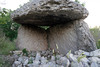
<< Text Pages >> Grotte des Fées (Lavilledieu) - Cave or Rock Shelter in France in Rhone:Ardèche (07)
Submitted by holger_rix on Thursday, 28 April 2016 Page Views: 897
Natural PlacesSite Name: Grotte des Fées (Lavilledieu)Country: France Département: Rhone:Ardèche (07) Type: Cave or Rock Shelter
Nearest Town: Largentière Nearest Village: Lavilledieu
Latitude: 44.585380N Longitude: 4.453900E
Condition:
| 5 | Perfect |
| 4 | Almost Perfect |
| 3 | Reasonable but with some damage |
| 2 | Ruined but still recognisable as an ancient site |
| 1 | Pretty much destroyed, possibly visible as crop marks |
| 0 | No data. |
| -1 | Completely destroyed |
| 5 | Superb |
| 4 | Good |
| 3 | Ordinary |
| 2 | Not Good |
| 1 | Awful |
| 0 | No data. |
| 5 | Can be driven to, probably with disabled access |
| 4 | Short walk on a footpath |
| 3 | Requiring a bit more of a walk |
| 2 | A long walk |
| 1 | In the middle of nowhere, a nightmare to find |
| 0 | No data. |
| 5 | co-ordinates taken by GPS or official recorded co-ordinates |
| 4 | co-ordinates scaled from a detailed map |
| 3 | co-ordinates scaled from a bad map |
| 2 | co-ordinates of the nearest village |
| 1 | co-ordinates of the nearest town |
| 0 | no data |
Be the first person to rate this site - see the 'Contribute!' box in the right hand menu.
Internal Links:
External Links:
Cave or Rock Shelter in Rhone:Ardèche (07)
Chemin de l'Ogre, Lavilledieu, Largentière, Ardèche, Auvergne-Rhône-Alpes
Source: T4T35.fr
You may be viewing yesterday's version of this page. To see the most up to date information please register for a free account.
Do not use the above information on other web sites or publications without permission of the contributor.
Nearby Images from Flickr
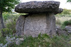


The above images may not be of the site on this page, but were taken nearby. They are loaded from Flickr so please click on them for image credits.
Click here to see more info for this site
Nearby sites
Click here to view sites on an interactive map of the areaKey: Red: member's photo, Blue: 3rd party photo, Yellow: other image, Green: no photo - please go there and take one, Grey: site destroyed
Download sites to:
KML (Google Earth)
GPX (GPS waypoints)
CSV (Garmin/Navman)
CSV (Excel)
To unlock full downloads you need to sign up as a Contributory Member. Otherwise downloads are limited to 50 sites.
Turn off the page maps and other distractions
Nearby sites listing. In the following links * = Image available
902m N 3° Dolmen de Chabolles Burial Chamber or Dolmen
928m N 1° Dolmen des Quatre Pierres 6 Burial Chamber or Dolmen
990m N 356° Tumulus des Quatre Pierres Round Cairn
1.0km N 358° Dolmen des Quatre Pierres 5 Burial Chamber or Dolmen
1.1km N 357° Dolmen des Quatre Pierres 4 Burial Chamber or Dolmen
1.1km N 355° Dolmen des Quatre Pierres 3* Burial Chamber or Dolmen
1.2km N 356° Dolmen des Quatre Pierres 2 Burial Chamber or Dolmen
1.2km N 355° Dolmen des Quatre Pierres 1* Burial Chamber or Dolmen
1.7km NNW 349° Dolmen de Mias 1* Burial Chamber or Dolmen
1.8km NNW 343° Dolmen de Mias 2 Burial Chamber or Dolmen
2.8km SSW 205° Dolmens de la Baume du Bois Barrow Cemetery
2.9km NW 306° Jastres Oppidium South Hillfort
3.0km WSW 259° Dolmen de Chapeyron 4 Burial Chamber or Dolmen
3.2km NW 315° Jastres Oppidium North Hillfort
3.3km WSW 245° Dolmen de Chapeyron 3 Burial Chamber or Dolmen
3.4km WSW 244° Dolmen de Chapeyron 2 Burial Chamber or Dolmen
3.6km WSW 238° Dolmens de Chapeyron Barrow Cemetery
3.9km SW 234° Dolmen de Chapeyron 1 Burial Chamber or Dolmen
6.0km N 358° Dolmen des Faysses Burial Chamber or Dolmen
6.8km N 11° Dolmen du Devès de Serre Burial Chamber or Dolmen
7.5km SW 216° Lanas C Burial Chamber or Dolmen
7.6km ENE 68° Troglodytes Grotte Cave or Rock Shelter
8.2km N 11° Menhir de Chante Epine Standing Stone (Menhir)
12.1km WSW 246° Dolmen de Vinezac Burial Chamber or Dolmen
12.8km SW 225° Dolmens du Pala Burial Chamber or Dolmen
View more nearby sites and additional images


 We would like to know more about this location. Please feel free to add a brief description and any relevant information in your own language.
 Wir möchten mehr über diese Stätte erfahren. Bitte zögern Sie nicht, eine kurze Beschreibung und relevante Informationen in Deutsch hinzuzufügen.
 Nous aimerions en savoir encore un peu sur les lieux. S'il vous plaît n'hesitez pas à ajouter une courte description et tous les renseignements pertinents dans votre propre langue.
 Quisieramos informarnos un poco más de las lugares. No dude en añadir una breve descripción y otros datos relevantes en su propio idioma.