

<< Our Photo Pages >> Hémicycle de Berder - Stone Circle in France in Bretagne:Morbihan (56)
Submitted by holger_rix on Saturday, 23 April 2016 Page Views: 1503
Neolithic and Bronze AgeSite Name: Hémicycle de BerderCountry: France Département: Bretagne:Morbihan (56) Type: Stone Circle
Nearest Town: Larmor-Baden Nearest Village: Berder
Latitude: 47.577972N Longitude: 2.891139W
Condition:
| 5 | Perfect |
| 4 | Almost Perfect |
| 3 | Reasonable but with some damage |
| 2 | Ruined but still recognisable as an ancient site |
| 1 | Pretty much destroyed, possibly visible as crop marks |
| 0 | No data. |
| -1 | Completely destroyed |
| 5 | Superb |
| 4 | Good |
| 3 | Ordinary |
| 2 | Not Good |
| 1 | Awful |
| 0 | No data. |
| 5 | Can be driven to, probably with disabled access |
| 4 | Short walk on a footpath |
| 3 | Requiring a bit more of a walk |
| 2 | A long walk |
| 1 | In the middle of nowhere, a nightmare to find |
| 0 | No data. |
| 5 | co-ordinates taken by GPS or official recorded co-ordinates |
| 4 | co-ordinates scaled from a detailed map |
| 3 | co-ordinates scaled from a bad map |
| 2 | co-ordinates of the nearest village |
| 1 | co-ordinates of the nearest town |
| 0 | no data |
Be the first person to rate this site - see the 'Contribute!' box in the right hand menu.
Internal Links:
External Links:
I have visited· I would like to visit
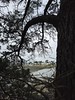
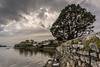
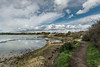
aolson visited on 16th Jul 2020 - their rating: Cond: 3 Amb: 4 Access: 3 A beautiful walk through the pine forest, and then a bit of a scramble down to the beach. The causeway to the island is only open at low tide, which is also when the site is most visible.
")
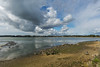
It is possible to walk out to the island at low tide, but please be aware of the tidal situation.
See also T4T35.fr
Picture:
www.t4t35.fr
You may be viewing yesterday's version of this page. To see the most up to date information please register for a free account.
")
")
Do not use the above information on other web sites or publications without permission of the contributor.
Nearby Images from Flickr
The above images may not be of the site on this page, but were taken nearby. They are loaded from Flickr so please click on them for image credits.
Click here to see more info for this site
Nearby sites
Click here to view sites on an interactive map of the areaKey: Red: member's photo, Blue: 3rd party photo, Yellow: other image, Green: no photo - please go there and take one, Grey: site destroyed
Download sites to:
KML (Google Earth)
GPX (GPS waypoints)
CSV (Garmin/Navman)
CSV (Excel)
To unlock full downloads you need to sign up as a Contributory Member. Otherwise downloads are limited to 50 sites.
Turn off the page maps and other distractions
Nearby sites listing. In the following links * = Image available
164m SSE 168° Dolmen de Berder* Burial Chamber or Dolmen
518m N 355° Tumulus d'Etal-Berder* Burial Chamber or Dolmen
666m NE 46° Dolmen de la Pointe de Berder* Burial Chamber or Dolmen
869m SW 218° Gavrinis Cairn* Cairn
1.2km SSW 200° Er Lannic* Stone Circle
1.7km SW 228° Île Longue tumulus* Chambered Tomb
2.6km SSW 209° Menhir de Monteno* Standing Stone (Menhir)
2.6km WNW 293° Dolmens de la Presqu'île de Couédic Burial Chamber or Dolmen
2.6km ESE 106° Dolmen de Pen-Hap* Burial Chamber or Dolmen
2.6km E 90° Menhir de Kerno (A) Standing Stone (Menhir)
2.7km S 180° Dolmen du Grah-Niol* Burial Chamber or Dolmen
2.7km E 83° Menhir de Kerno (B)* Standing Stone (Menhir)
2.7km E 80° Kerno Dolmen* Burial Chamber or Dolmen
2.8km ENE 72° Dolmen De Kerno II* Burial Chamber or Dolmen
2.8km E 92° Dolmen de Roh-Vras Burial Chamber or Dolmen
2.9km SW 217° Bilgroix Point Menhir* Modern Stone Circle etc
2.9km SE 125° Dolmens de Nioul Burial Chamber or Dolmen
2.9km SW 215° Bilgroix allée couverte* Passage Grave
3.0km SSE 152° Pen Castel menhir Standing Stone (Menhir)
3.1km SE 130° Pointe de Nioul dolmen Burial Chamber or Dolmen
3.3km NW 309° Dolmens de Mané-Ven-Guen* Burial Chamber or Dolmen
3.3km ENE 64° Kergonan Cromlech* Stone Circle
3.3km SW 232° Menhir de Goémorent Standing Stone (Menhir)
3.4km SSW 201° Menhir de Bourgneuf Standing Stone (Menhir)
3.4km NW 314° Pointe de Toulvern Dolmen* Burial Chamber or Dolmen
View more nearby sites and additional images


 We would like to know more about this location. Please feel free to add a brief description and any relevant information in your own language.
 Wir möchten mehr über diese Stätte erfahren. Bitte zögern Sie nicht, eine kurze Beschreibung und relevante Informationen in Deutsch hinzuzufügen.
 Nous aimerions en savoir encore un peu sur les lieux. S'il vous plaît n'hesitez pas à ajouter une courte description et tous les renseignements pertinents dans votre propre langue.
 Quisieramos informarnos un poco más de las lugares. No dude en añadir una breve descripción y otros datos relevantes en su propio idioma.