

<< Text Pages >> Polissoir de la Vallée d'Armeau - Polissoir in France in Bourgogne:Yonne (89)
Submitted by holger_rix on Thursday, 14 April 2016 Page Views: 809
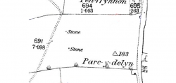
Neolithic and Bronze AgeSite Name: Polissoir de la Vallée d'ArmeauCountry: France Département: Bourgogne:Yonne (89) Type: Polissoir
Nearest Town: Sens Nearest Village: Dixmont
Latitude: 48.081500N Longitude: 3.414300E
Condition:
| 5 | Perfect |
| 4 | Almost Perfect |
| 3 | Reasonable but with some damage |
| 2 | Ruined but still recognisable as an ancient site |
| 1 | Pretty much destroyed, possibly visible as crop marks |
| 0 | No data. |
| -1 | Completely destroyed |
| 5 | Superb |
| 4 | Good |
| 3 | Ordinary |
| 2 | Not Good |
| 1 | Awful |
| 0 | No data. |
| 5 | Can be driven to, probably with disabled access |
| 4 | Short walk on a footpath |
| 3 | Requiring a bit more of a walk |
| 2 | A long walk |
| 1 | In the middle of nowhere, a nightmare to find |
| 0 | No data. |
| 5 | co-ordinates taken by GPS or official recorded co-ordinates |
| 4 | co-ordinates scaled from a detailed map |
| 3 | co-ordinates scaled from a bad map |
| 2 | co-ordinates of the nearest village |
| 1 | co-ordinates of the nearest town |
| 0 | no data |
Be the first person to rate this site - see the 'Contribute!' box in the right hand menu.
Internal Links:
External Links:
Polissoir in Bourgogne:Yonne (89)
Dixmont, Sens, Yonne, Bourgogne-Franche-Comté
Source: Wikipedia article
Sites mégalithiques de l'Yonne
Picture:
www.t4t35.fr
You may be viewing yesterday's version of this page. To see the most up to date information please register for a free account.
Do not use the above information on other web sites or publications without permission of the contributor.
Nearby Images from Flickr

The above images may not be of the site on this page, but were taken nearby. They are loaded from Flickr so please click on them for image credits.
Click here to see more info for this site
Nearby sites
Click here to view sites on an interactive map of the areaKey: Red: member's photo, Blue: 3rd party photo, Yellow: other image, Green: no photo - please go there and take one, Grey: site destroyed
Download sites to:
KML (Google Earth)
GPX (GPS waypoints)
CSV (Garmin/Navman)
CSV (Excel)
To unlock full downloads you need to sign up as a Contributory Member. Otherwise downloads are limited to 50 sites.
Turn off the page maps and other distractions
Nearby sites listing. In the following links * = Image available
3.9km ENE 75° Polissoir de la Borde à la Gousse Polissoir
3.9km ENE 74° Dolmen de la Bourde à la Gousse Burial Chamber or Dolmen
4.0km SE 129° Menhir du Bois de l'Enfourchure Standing Stone (Menhir)
6.3km NNW 345° La Borne-Percée* Standing Stone (Menhir)
7.8km NNW 343° Polissoirs des Feignants Polissoir
7.9km W 273° Polissoir dit la Pierre qui sent l'Huile Polissoir
8.0km WSW 239° Les Drecuits Burial Chamber or Dolmen
8.3km NNE 13° La Pierre-Aux-Sorcières* Standing Stone (Menhir)
8.8km WNW 292° La Sabliere Burial Chamber or Dolmen
9.7km W 259° Pierre-Fritte (Villeneuve-sur-Yonne) Standing Stone (Menhir)
9.7km NW 304° Les Durillons Burial Chamber or Dolmen
11.8km NNW 333° Cocquevelee Burial Chamber or Dolmen
12.3km NE 53° Menhir dit la Pierre à Colon Standing Stone (Menhir)
14.3km NW 308° Les Sablons Burial Chamber or Dolmen
15.4km WSW 237° Menhir dit la Grande Ménagère Standing Stone (Menhir)
16.0km W 278° Menhir d'Egriselles-le-Bocage* Standing Stone (Menhir)
16.9km SSE 148° Les Groseillers Burial Chamber or Dolmen
17.1km WSW 241° Menhir du Bois Michot Standing Stone (Menhir)
17.5km NNE 28° Tumulus de la Tommelle Round Barrow(s)
18.6km SSE 154° Le Poirier Burial Chamber or Dolmen
19.6km NE 43° Polissoirs du Bois des Coudriers 1 Polissoir
19.7km NNW 341° La Roche-aux-Gravures Burial Chamber or Dolmen
19.9km NE 43° Polissoirs du Bois des Coudriers 2 Polissoir
19.9km NNE 26° Le Bas-de-Cuisard Burial Chamber or Dolmen
21.0km SSE 161° Sur-les-Patureaux Burial Chamber or Dolmen
View more nearby sites and additional images


 We would like to know more about this location. Please feel free to add a brief description and any relevant information in your own language.
 Wir möchten mehr über diese Stätte erfahren. Bitte zögern Sie nicht, eine kurze Beschreibung und relevante Informationen in Deutsch hinzuzufügen.
 Nous aimerions en savoir encore un peu sur les lieux. S'il vous plaît n'hesitez pas à ajouter une courte description et tous les renseignements pertinents dans votre propre langue.
 Quisieramos informarnos un poco más de las lugares. No dude en añadir una breve descripción y otros datos relevantes en su propio idioma.