


<< Text Pages >> Menhirs de l'Île-d'Yoc'h - Standing Stones in France in Bretagne:Finistère (29)
Submitted by holger_rix on Tuesday, 29 March 2016 Page Views: 768
Neolithic and Bronze AgeSite Name: Menhirs de l'Île-d'Yoc'hCountry: France Département: Bretagne:Finistère (29) Type: Standing Stones
Nearest Town: Landunvez Nearest Village: Île-d'Yoc'h
Latitude: 48.527588N Longitude: 4.775277W
Condition:
| 5 | Perfect |
| 4 | Almost Perfect |
| 3 | Reasonable but with some damage |
| 2 | Ruined but still recognisable as an ancient site |
| 1 | Pretty much destroyed, possibly visible as crop marks |
| 0 | No data. |
| -1 | Completely destroyed |
| 5 | Superb |
| 4 | Good |
| 3 | Ordinary |
| 2 | Not Good |
| 1 | Awful |
| 0 | No data. |
| 5 | Can be driven to, probably with disabled access |
| 4 | Short walk on a footpath |
| 3 | Requiring a bit more of a walk |
| 2 | A long walk |
| 1 | In the middle of nowhere, a nightmare to find |
| 0 | No data. |
| 5 | co-ordinates taken by GPS or official recorded co-ordinates |
| 4 | co-ordinates scaled from a detailed map |
| 3 | co-ordinates scaled from a bad map |
| 2 | co-ordinates of the nearest village |
| 1 | co-ordinates of the nearest town |
| 0 | no data |
Be the first person to rate this site - see the 'Contribute!' box in the right hand menu.
Internal Links:
External Links:
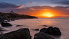
Remains of fallen menhirs on the Île-d'Yoc'h
Île d'Yoc'h, Landunvez, Brest, Finistère, Brittany
Source: T4T35.fr
You may be viewing yesterday's version of this page. To see the most up to date information please register for a free account.
Do not use the above information on other web sites or publications without permission of the contributor.
Nearby Images from Flickr

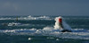
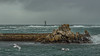
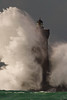
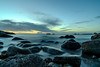
The above images may not be of the site on this page, but were taken nearby. They are loaded from Flickr so please click on them for image credits.
Click here to see more info for this site
Nearby sites
Click here to view sites on an interactive map of the areaKey: Red: member's photo, Blue: 3rd party photo, Yellow: other image, Green: no photo - please go there and take one, Grey: site destroyed
Download sites to:
KML (Google Earth)
GPX (GPS waypoints)
CSV (Garmin/Navman)
CSV (Excel)
To unlock full downloads you need to sign up as a Contributory Member. Otherwise downloads are limited to 50 sites.
Turn off the page maps and other distractions
Nearby sites listing. In the following links * = Image available
158m N 7° Dolmen Île-d'Yoc'h Burial Chamber or Dolmen
977m S 181° Parc-ar-Varret cromlech* Stone Circle
1.2km S 174° Dolmen de Beg-ar-Vir* Burial Chamber or Dolmen
1.2km E 83° Dolmen de Men-Milliget* Burial Chamber or Dolmen
1.4km S 173° Parc-ar-Varret menhirs* Standing Stones
2.0km ENE 77° Menhir de Penfoul* Standing Stone (Menhir)
2.1km ENE 73° Menhir de Penquer* Standing Stone (Menhir)
2.2km ENE 76° Dolmen de Penn-al-Lann Burial Chamber or Dolmen
2.4km ENE 66° Menhirs de Kerlaguen* Standing Stones
2.4km SSE 157° Cupules du Spernoc Rock Art
2.4km S 177° Dolmen de la Pointe du Dreff* Burial Chamber or Dolmen
2.5km NE 54° Tumulus de la pointe de Landunvez* Chambered Cairn
2.6km SE 138° Menhir de Prat Bihan* Standing Stone (Menhir)
2.7km SE 135° Menhir de Kerhouézel* Standing Stone (Menhir)
2.7km ESE 116° Menhirs de Kerguiabo* Standing Stones
3.3km ESE 111° Menhir de Kerveleoc Standing Stone (Menhir)
3.3km NE 51° Menhir de Kerandraon Standing Stone (Menhir)
3.4km S 176° Dolmen de Kerizella* Burial Chamber or Dolmen
3.4km NE 51° Affleurement à cupules de Kerandraon Rock Art
3.4km SSE 164° Kerivoret Dolmen* Burial Chamber or Dolmen
3.5km SSE 164° Kerivoret Menhir* Standing Stone (Menhir)
3.8km ESE 107° Saint-Gonvarc'h menhir* Standing Stone (Menhir)
3.8km SSE 152° Saint-Denec Alignement de Menhirs* Stone Row / Alignment
3.8km NE 50° St Samson's Well (Landunvez)* Holy Well or Sacred Spring
3.8km SSE 162° Menhir de Calès Standing Stone (Menhir)
View more nearby sites and additional images


 We would like to know more about this location. Please feel free to add a brief description and any relevant information in your own language.
 Wir möchten mehr über diese Stätte erfahren. Bitte zögern Sie nicht, eine kurze Beschreibung und relevante Informationen in Deutsch hinzuzufügen.
 Nous aimerions en savoir encore un peu sur les lieux. S'il vous plaît n'hesitez pas à ajouter une courte description et tous les renseignements pertinents dans votre propre langue.
 Quisieramos informarnos un poco más de las lugares. No dude en añadir una breve descripción y otros datos relevantes en su propio idioma.