


<< Text Pages >> Dolmen de Lesconil - Burial Chamber or Dolmen in France in Bretagne:Finistère (29)
Submitted by holger_rix on Sunday, 28 February 2016 Page Views: 1430
Neolithic and Bronze AgeSite Name: Dolmen de LesconilCountry: France Département: Bretagne:Finistère (29) Type: Burial Chamber or Dolmen
Nearest Town: Poullan-sur-Mer Nearest Village: Leskonil
Latitude: 48.089808N Longitude: 4.378969W
Condition:
| 5 | Perfect |
| 4 | Almost Perfect |
| 3 | Reasonable but with some damage |
| 2 | Ruined but still recognisable as an ancient site |
| 1 | Pretty much destroyed, possibly visible as crop marks |
| 0 | No data. |
| -1 | Completely destroyed |
| 5 | Superb |
| 4 | Good |
| 3 | Ordinary |
| 2 | Not Good |
| 1 | Awful |
| 0 | No data. |
| 5 | Can be driven to, probably with disabled access |
| 4 | Short walk on a footpath |
| 3 | Requiring a bit more of a walk |
| 2 | A long walk |
| 1 | In the middle of nowhere, a nightmare to find |
| 0 | No data. |
| 5 | co-ordinates taken by GPS or official recorded co-ordinates |
| 4 | co-ordinates scaled from a detailed map |
| 3 | co-ordinates scaled from a bad map |
| 2 | co-ordinates of the nearest village |
| 1 | co-ordinates of the nearest town |
| 0 | no data |
Be the first person to rate this site - see the 'Contribute!' box in the right hand menu.
Internal Links:
External Links:
Burial Chamber (Dolmen) in Bretagne:Finistère (29)
Leskonil, Poullan-sur-Mer, Quimper, Finistère, Brittany
Source: T4T35.fr
You may be viewing yesterday's version of this page. To see the most up to date information please register for a free account.
")
Do not use the above information on other web sites or publications without permission of the contributor.
Nearby Images from Flickr
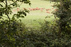
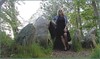
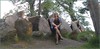
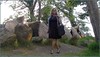


The above images may not be of the site on this page, but were taken nearby. They are loaded from Flickr so please click on them for image credits.
Click here to see more info for this site
Nearby sites
Click here to view sites on an interactive map of the areaKey: Red: member's photo, Blue: 3rd party photo, Yellow: other image, Green: no photo - please go there and take one, Grey: site destroyed
Download sites to:
KML (Google Earth)
GPX (GPS waypoints)
CSV (Garmin/Navman)
CSV (Excel)
To unlock full downloads you need to sign up as a Contributory Member. Otherwise downloads are limited to 50 sites.
Turn off the page maps and other distractions
Nearby sites listing. In the following links * = Image available
236m N 350° Lesconil allée couverte* Passage Grave
528m N 9° Dolmen du Manoir de Treota Burial Chamber or Dolmen
997m NNW 330° Tréota menhir Standing Stone (Menhir)
1.4km N 2° Menhir de Kergavan 1 Standing Stone (Menhir)
1.8km N 352° Menhir de Kergavan 2* Standing Stone (Menhir)
2.1km ENE 64° Sables Blancs menhir* Standing Stone (Menhir)
2.3km WNW 294° Menhir de Kermenhir* Standing Stone (Menhir)
2.3km ENE 72° Croix dite Croas-Men Standing Stone (Menhir)
2.8km E 98° Tréboul menhir* Standing Stone (Menhir)
3.3km SSW 212° Menhir de la Chapelle de Kerinec* Standing Stone (Menhir)
3.4km SSW 212° Dolmen de la Chapelle de Kerinec* Burial Chamber or Dolmen
3.5km W 278° Lésaouvréguen menhir Standing Stone (Menhir)
5.7km W 263° Kerbalanec Allée Couverte* Passage Grave
6.2km W 275° Vaisseau de Pierre de Saint Conogan* Standing Stone (Menhir)
7.9km E 89° Menhir in Kerlaz* Standing Stone (Menhir)
10.1km ENE 59° St Anne's Fountain (Sainte Anne La Palud) Holy Well or Sacred Spring
10.1km NE 51° Coffres de Ty an Quer Cist
10.6km W 270° Kastell Koz* Promontory Fort / Cliff Castle
11.5km W 267° Luguenez menhir* Standing Stone (Menhir)
12.1km SSW 197° Menhir de Plozevet* Standing Stone (Menhir)
12.1km SSW 197° Face au Penker menhir Standing Stone (Menhir)
12.6km S 185° Menhir de Lestrouquy* Standing Stone (Menhir)
12.7km S 182° Menhir de Kervinou (Plozévet) Standing Stone (Menhir)
12.7km E 86° Menhir dit la Jument Blanche* Standing Stone (Menhir)
12.8km E 90° Pierre de Kazeg Ven* Burial Chamber or Dolmen
View more nearby sites and additional images


 We would like to know more about this location. Please feel free to add a brief description and any relevant information in your own language.
 Wir möchten mehr über diese Stätte erfahren. Bitte zögern Sie nicht, eine kurze Beschreibung und relevante Informationen in Deutsch hinzuzufügen.
 Nous aimerions en savoir encore un peu sur les lieux. S'il vous plaît n'hesitez pas à ajouter une courte description et tous les renseignements pertinents dans votre propre langue.
 Quisieramos informarnos un poco más de las lugares. No dude en añadir una breve descripción y otros datos relevantes en su propio idioma.