

<< Our Photo Pages >> The Gathering Stone - Standing Stone (Menhir) in Scotland in Stirling
Submitted by davidmorgan on Sunday, 17 January 2016 Page Views: 6289
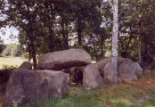
Neolithic and Bronze AgeSite Name: The Gathering Stone Alternative Name: Sheriffmuir Battle Stone; Battle Stone; Beltane Stone; Karling StoneCountry: Scotland County: Stirling Type: Standing Stone (Menhir)
Nearest Town: Dunblane Nearest Village: Sheriffmuir
Map Ref: NN8105602191
Latitude: 56.197418N Longitude: 3.918589W
Condition:
| 5 | Perfect |
| 4 | Almost Perfect |
| 3 | Reasonable but with some damage |
| 2 | Ruined but still recognisable as an ancient site |
| 1 | Pretty much destroyed, possibly visible as crop marks |
| 0 | No data. |
| -1 | Completely destroyed |
| 5 | Superb |
| 4 | Good |
| 3 | Ordinary |
| 2 | Not Good |
| 1 | Awful |
| 0 | No data. |
| 5 | Can be driven to, probably with disabled access |
| 4 | Short walk on a footpath |
| 3 | Requiring a bit more of a walk |
| 2 | A long walk |
| 1 | In the middle of nowhere, a nightmare to find |
| 0 | No data. |
| 5 | co-ordinates taken by GPS or official recorded co-ordinates |
| 4 | co-ordinates scaled from a detailed map |
| 3 | co-ordinates scaled from a bad map |
| 2 | co-ordinates of the nearest village |
| 1 | co-ordinates of the nearest town |
| 0 | no data |
Internal Links:
External Links:
I have visited· I would like to visit
Anne T visited on 13th Jul 2018 - their rating: Cond: 3 Amb: 4 Access: 4 The Gathering Stone, Sheriffmuir: From the Sheriffmuir Cairn & Macrae Clan Monument at NN 81569 01934, we followed the footpath to its eastern side, between the main monument and the cairn, following the line of the stone wall, heading in a roughly north westerly direction.
Eventually a path split off to our left, slightly more westwards and this led us to the Gathering Stone – a strange, strange sight, being protected by its ‘iron ribs’. It most definitely looks like a recumbent standing stone, now split into at least three parts.
The ribs are very reminiscent of graves covered to protect them from graverobbers. To me, in this setting, it felt like the iron bars constrained the standing stone from getting up off the ground and becoming upright again.
Continuing slightly further west along the track, you cross some rocks which have been much graffitied. We read that the mounds of earth here are the graves of 600 of the fallen from the Battle of Sheriffmuir.
")
This stone is recorded as Canmore site no. 25277, which includes an extract of an 1893 journal, which reads: "(this is) a block of Highland grit, at the junction of which the standard of the Scottish clans is said to have been placed (1715) … it is called locally Battle Stone and is said to have been formerly known as the Beltane Stane. Has the appearance, 'as far as it can now been seen", of an overthrown standing stone'."
Canmore tells us the stone was encased in an iron cage in 1840, which is inscribed 'The Gathering Stone of the Highland army on the day of the memorable battle of Sheriffmuir, fought in November 1715'.
A further note on the Canmore record, dated 1978 reads: "may be a fallen standing stone". RCAHMS could not verify the local name 'Beltane Stane'.
You may be viewing yesterday's version of this page. To see the most up to date information please register for a free account.
")
")
")
")
")
Do not use the above information on other web sites or publications without permission of the contributor.
Click here to see more info for this site
Nearby sites
Key: Red: member's photo, Blue: 3rd party photo, Yellow: other image, Green: no photo - please go there and take one, Grey: site destroyed
Download sites to:
KML (Google Earth)
GPX (GPS waypoints)
CSV (Garmin/Navman)
CSV (Excel)
To unlock full downloads you need to sign up as a Contributory Member. Otherwise downloads are limited to 50 sites.
Turn off the page maps and other distractions
Nearby sites listing. In the following links * = Image available
2.1km NNW 346° White Stone* Standing Stones (NN80630420)
2.2km E 87° Sheriff Muir Row* Stone Row / Alignment (NN83240226)
2.5km S 171° The Great Stane O' Pendreigh* Standing Stone (Menhir) (NS8138299686)
2.8km S 175° Pendreich 2 (Bridge of Allan) Cairn (NS81239938)
2.9km S 177° Split Stone (Bridge of Allan) Standing Stone (Menhir) (NS8111699311)
2.9km ENE 68° Harperstone (Dunblane) Stone Circle (NN838032)
3.0km S 175° Pendreich 1 (Bridge of Allan) Cairn (NS8124499236)
3.0km S 175° Pendreich 3 (Bridge of Allan) Cairn (NS81259922)
3.0km WSW 252° Dunblane Museum* Museum (NN7819301343)
3.0km WSW 253° Dunblane Cathedral* Class III Pictish Cross Slab (NN78170139)
3.1km S 190° Cuparlaw Wood (Bridge of Allan) Cairn (NS80469916)
3.2km SW 234° Kippenross House (Dunblane) Cairn (NN78370036)
4.2km S 174° Fairy Well (Logie)* Holy Well or Sacred Spring (NS81359804)
4.3km SSW 198° Fairy Knowe (Bridge of Allan)* Cairn (NS79619818)
5.1km S 190° Lentran (Bridge of Allan) Cist (NS80039720)
5.2km S 173° Logie Old Kirk (Stirling)* Early Christian Sculptured Stone (NS81549696)
5.3km S 183° Pathfoot Stone* Standing Stone (Menhir) (NS8060496871)
5.6km S 175° The Victoria Stone* Marker Stone (NS8141296608)
5.6km WSW 256° Glenhead Standing Stone (Doune)* Standing Stone (Menhir) (NN75520100)
5.7km S 175° Airthrey Stone* Standing Stone (Menhir) (NS81409650)
5.8km WSW 251° Doune (Glenhead)* Stone Row / Alignment (NN7549300457)
5.8km ESE 104° Bengengie North Ancient Village or Settlement (NN8668000601)
6.4km S 183° Bel Stane (Causewayhead) Standing Stone (Menhir) (NS805958)
6.5km NE 52° Wester Biggs (Dunblane)* Stone Circle (NN86270608)
6.5km S 179° Abbey Craig Vitrified Fort* Hillfort (NS80949565)
View more nearby sites and additional images


 We would like to know more about this location. Please feel free to add a brief description and any relevant information in your own language.
 Wir möchten mehr über diese Stätte erfahren. Bitte zögern Sie nicht, eine kurze Beschreibung und relevante Informationen in Deutsch hinzuzufügen.
 Nous aimerions en savoir encore un peu sur les lieux. S'il vous plaît n'hesitez pas à ajouter une courte description et tous les renseignements pertinents dans votre propre langue.
 Quisieramos informarnos un poco más de las lugares. No dude en añadir una breve descripción y otros datos relevantes en su propio idioma.