

<< Text Pages >> Cairns de Voguer Men - Chambered Cairn in France in Bretagne:Finistère (29)
Submitted by holger_rix on Thursday, 14 January 2016 Page Views: 958
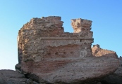
Neolithic and Bronze AgeSite Name: Cairns de Voguer MenCountry: France Département: Bretagne:Finistère (29) Type: Chambered Cairn
Nearest Town: Plogoff Nearest Village: Pont Quillioc
Latitude: 48.024418N Longitude: 4.645002W
Condition:
| 5 | Perfect |
| 4 | Almost Perfect |
| 3 | Reasonable but with some damage |
| 2 | Ruined but still recognisable as an ancient site |
| 1 | Pretty much destroyed, possibly visible as crop marks |
| 0 | No data. |
| -1 | Completely destroyed |
| 5 | Superb |
| 4 | Good |
| 3 | Ordinary |
| 2 | Not Good |
| 1 | Awful |
| 0 | No data. |
| 5 | Can be driven to, probably with disabled access |
| 4 | Short walk on a footpath |
| 3 | Requiring a bit more of a walk |
| 2 | A long walk |
| 1 | In the middle of nowhere, a nightmare to find |
| 0 | No data. |
| 5 | co-ordinates taken by GPS or official recorded co-ordinates |
| 4 | co-ordinates scaled from a detailed map |
| 3 | co-ordinates scaled from a bad map |
| 2 | co-ordinates of the nearest village |
| 1 | co-ordinates of the nearest town |
| 0 | no data |
Be the first person to rate this site - see the 'Contribute!' box in the right hand menu.
Internal Links:
External Links:
Cairn in Bretagne:Finistère (29)
Pont Quillioc, Plogoff, Quimper, Finistère, Brittany
Source: T4T35.fr
You may be viewing yesterday's version of this page. To see the most up to date information please register for a free account.
Do not use the above information on other web sites or publications without permission of the contributor.
Nearby Images from Flickr
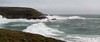

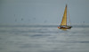
The above images may not be of the site on this page, but were taken nearby. They are loaded from Flickr so please click on them for image credits.
Click here to see more info for this site
Nearby sites
Click here to view sites on an interactive map of the areaKey: Red: member's photo, Blue: 3rd party photo, Yellow: other image, Green: no photo - please go there and take one, Grey: site destroyed
Download sites to:
KML (Google Earth)
GPX (GPS waypoints)
CSV (Garmin/Navman)
CSV (Excel)
To unlock full downloads you need to sign up as a Contributory Member. Otherwise downloads are limited to 50 sites.
Turn off the page maps and other distractions
Nearby sites listing. In the following links * = Image available
621m NNW 327° Chapelle Notre-Dame de Bon Voyage cairns* Chambered Cairn
2.6km E 88° Primelin stèle* Standing Stone (Menhir)
3.1km E 84° Dolmen de la Chapelle Sainte-Théodore* Burial Chamber or Dolmen
3.9km E 94° St. Tugen holy well* Holy Well or Sacred Spring
4.7km WNW 292° Lescoff Village menhir* Standing Stone (Menhir)
4.9km NNE 18° Dolmen de Penharn* Burial Chamber or Dolmen
5.0km WNW 297° Baie des Trépassés mégalithe* Standing Stone (Menhir)
5.2km NW 305° Dolmen de Menez Liaven Burial Chamber or Dolmen
5.2km NE 48° Saint-Goulien stèles* Standing Stones
6.9km NE 55° Chapelle de Lannourec stèle* Standing Stone (Menhir)
9.5km E 99° Saint-Dreyel mégalithe Standing Stone (Menhir)
10.6km NE 51° Luguenez menhir* Standing Stone (Menhir)
11.7km NE 52° Kastell Koz* Promontory Fort / Cliff Castle
13.3km ESE 107° Dolmens de Menez Dregan 2* Burial Chamber or Dolmen
13.3km ESE 108° Cairn de Menez Dregan * Chambered Cairn
13.4km ESE 109° Grotte de Menez Dregan* Cave or Rock Shelter
14.0km ESE 108° Pors Poulhan allée couverte* Passage Grave
14.1km ESE 108° Dolmen De Pors Poulhan* Burial Chamber or Dolmen
14.3km W 273° Allée Couverte de l'Îlot de Kélaourou Passage Grave
15.4km W 276° Chapelle Saint-Guénolé Standing Stone (Menhir)
15.4km W 276° Dolmen dit le Nifran Burial Chamber or Dolmen
15.4km W 276° Les Causeurs* Standing Stones
15.6km ENE 65° Kerbalanec Allée Couverte* Passage Grave
15.6km ENE 60° Vaisseau de Pierre de Saint Conogan* Standing Stone (Menhir)
16.0km W 276° Menhir de Kourijou Standing Stone (Menhir)
View more nearby sites and additional images


 We would like to know more about this location. Please feel free to add a brief description and any relevant information in your own language.
 Wir möchten mehr über diese Stätte erfahren. Bitte zögern Sie nicht, eine kurze Beschreibung und relevante Informationen in Deutsch hinzuzufügen.
 Nous aimerions en savoir encore un peu sur les lieux. S'il vous plaît n'hesitez pas à ajouter une courte description et tous les renseignements pertinents dans votre propre langue.
 Quisieramos informarnos un poco más de las lugares. No dude en añadir una breve descripción y otros datos relevantes en su propio idioma.