

<< Our Photo Pages >> D54 Havelterberg - Passage Grave in Netherlands in Drenthe
Submitted by Sunflowerbird on Sunday, 22 April 2018 Page Views: 9130
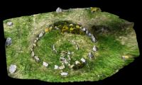
Neolithic and Bronze AgeSite Name: D54 Havelterberg Alternative Name: Havelte-OostCountry: Netherlands Province: Drenthe Type: Passage Grave
Nearest Town: Steenwijk Nearest Village: Havelte
Latitude: 52.792570N Longitude: 6.220550E
Condition:
| 5 | Perfect |
| 4 | Almost Perfect |
| 3 | Reasonable but with some damage |
| 2 | Ruined but still recognisable as an ancient site |
| 1 | Pretty much destroyed, possibly visible as crop marks |
| 0 | No data. |
| -1 | Completely destroyed |
| 5 | Superb |
| 4 | Good |
| 3 | Ordinary |
| 2 | Not Good |
| 1 | Awful |
| 0 | No data. |
| 5 | Can be driven to, probably with disabled access |
| 4 | Short walk on a footpath |
| 3 | Requiring a bit more of a walk |
| 2 | A long walk |
| 1 | In the middle of nowhere, a nightmare to find |
| 0 | No data. |
| 5 | co-ordinates taken by GPS or official recorded co-ordinates |
| 4 | co-ordinates scaled from a detailed map |
| 3 | co-ordinates scaled from a bad map |
| 2 | co-ordinates of the nearest village |
| 1 | co-ordinates of the nearest town |
| 0 | no data |
Internal Links:
External Links:
I have visited· I would like to visit
johnstone visited on 24th Jun 2021 - their rating: Cond: 4 Amb: 4 Access: 5
XIII visited on 2nd Jul 2016 - their rating: Cond: 3 Amb: 4 Access: 5
Podovsky visited on 11th Aug 2013 - their rating: Cond: 4 Amb: 4 Access: 4
johnstone visited on 15th Apr 2005 - their rating: Cond: 5 Amb: 5 Access: 5
SolarMegalith visited on 1st Aug 2004 - their rating: Cond: 3 Amb: 3 Access: 4
Martin_L DrewParsons have visited here
Average ratings for this site from all visit loggers: Condition: 3.8 Ambience: 4 Access: 4.6
")
Monumentenregister (Historic Monument)
Hunebeddeninfo (Dutch Information)
Short info (Site Hans Meijer)
You may be viewing yesterday's version of this page. To see the most up to date information please register for a free account.
")
")
")
")
")
")
")
")
")
")
")
")
")
")
")
")
Do not use the above information on other web sites or publications without permission of the contributor.
Click here to see more info for this site
Nearby sites
Click here to view sites on an interactive map of the areaKey: Red: member's photo, Blue: 3rd party photo, Yellow: other image, Green: no photo - please go there and take one, Grey: site destroyed
Download sites to:
KML (Google Earth)
GPX (GPS waypoints)
CSV (Garmin/Navman)
CSV (Excel)
To unlock full downloads you need to sign up as a Contributory Member. Otherwise downloads are limited to 50 sites.
![]()
![]()
Turn off the page maps and other distractions
Nearby sites listing. In the following links * = Image available
160m W 269° D53 Havelterberg* Passage Grave
332m WSW 258° Zwerfsteen Havelte* Natural Stone / Erratic / Other Natural Feature
7.5km WNW 291° Koe en Kalf* Natural Stone / Erratic / Other Natural Feature
8.2km NW 306° Grafheuvel Eesveen (46048) Round Barrow(s)
8.4km WNW 298° Grafheuvel Eesveen (46049) Round Barrow(s)
8.4km NW 313° O1 De Eese* Chambered Tomb
8.6km WNW 295° Grafheuvels Eesveen (46050) Round Barrow(s)
8.8km N 4° Koelingsveld* Barrow Cemetery
9.1km W 281° Geologisch Monument Wolterholten* Natural Stone / Erratic / Other Natural Feature
9.6km NE 43° OERmuseum West-Drenthe* Museum
9.7km WNW 299° Grafheuvels Steenwijkerwold (46051) Round Barrow(s)
10.1km NNE 28° D52a Diever* Passage Grave
10.5km NE 45° D52 Diever* Passage Grave
10.9km NE 45° Steenkist van Diever* Cist
13.3km NNE 31° Grafheuvel Schepershut* Round Barrow(s)
20.1km N 8° Langedijke (45878) Ancient Village or Settlement
21.3km N 354° Twijtel (45879) Ancient Village or Settlement
23.9km NE 44° Veenbruggen Smilde Ancient Trackway
24.5km N 7° Donkerbroek (45875) Ancient Village or Settlement
25.6km NNW 336° Museum Opsterlân Museum
25.8km NNE 15° Oosterwolde (45874) Ancient Village or Settlement
26.0km NW 308° Zwerfsteen van Rottum* Natural Stone / Erratic / Other Natural Feature
27.5km ENE 58° D54b Hooghalen* Passage Grave
27.9km ENE 58° Hooghalen Steenkist Cist
28.0km ENE 58° D54c Hooghalen* Chambered Tomb
View more nearby sites and additional images


 We would like to know more about this location. Please feel free to add a brief description and any relevant information in your own language.
 Wir möchten mehr über diese Stätte erfahren. Bitte zögern Sie nicht, eine kurze Beschreibung und relevante Informationen in Deutsch hinzuzufügen.
 Nous aimerions en savoir encore un peu sur les lieux. S'il vous plaît n'hesitez pas à ajouter une courte description et tous les renseignements pertinents dans votre propre langue.
 Quisieramos informarnos un poco más de las lugares. No dude en añadir una breve descripción y otros datos relevantes en su propio idioma.