

<< Our Photo Pages >> Roc'h ar Lein Menhir - Standing Stone (Menhir) in France in Bretagne:Côtes-D'Armor (22)
Submitted by Ogham on Saturday, 30 June 2012 Page Views: 3362
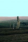
Neolithic and Bronze AgeSite Name: Roc'h ar Lein Menhir Alternative Name: Roc'h-ar-Lin, Roch-ar-Leim, Men BrazCountry: France Département: Bretagne:Côtes-D'Armor (22) Type: Standing Stone (Menhir)
Nearest Town: Loudéac Nearest Village: Saint-Mayeux
Latitude: 48.257843N Longitude: 3.030962W
Condition:
| 5 | Perfect |
| 4 | Almost Perfect |
| 3 | Reasonable but with some damage |
| 2 | Ruined but still recognisable as an ancient site |
| 1 | Pretty much destroyed, possibly visible as crop marks |
| 0 | No data. |
| -1 | Completely destroyed |
| 5 | Superb |
| 4 | Good |
| 3 | Ordinary |
| 2 | Not Good |
| 1 | Awful |
| 0 | No data. |
| 5 | Can be driven to, probably with disabled access |
| 4 | Short walk on a footpath |
| 3 | Requiring a bit more of a walk |
| 2 | A long walk |
| 1 | In the middle of nowhere, a nightmare to find |
| 0 | No data. |
| 5 | co-ordinates taken by GPS or official recorded co-ordinates |
| 4 | co-ordinates scaled from a detailed map |
| 3 | co-ordinates scaled from a bad map |
| 2 | co-ordinates of the nearest village |
| 1 | co-ordinates of the nearest town |
| 0 | no data |
Internal Links:
External Links:
I have visited· I would like to visit
johnstone visited on 19th Jun 2023 - their rating: Cond: 4 Amb: 4 Access: 4
Ogham have visited here
")
It is a pleasant walk from the road through the woods, access is quite easy.
You may be viewing yesterday's version of this page. To see the most up to date information please register for a free account.
")
")
")
")
")
")
")
Do not use the above information on other web sites or publications without permission of the contributor.
Click here to see more info for this site
Nearby sites
Click here to view sites on an interactive map of the areaKey: Red: member's photo, Blue: 3rd party photo, Yellow: other image, Green: no photo - please go there and take one, Grey: site destroyed
Download sites to:
KML (Google Earth)
GPX (GPS waypoints)
CSV (Garmin/Navman)
CSV (Excel)
To unlock full downloads you need to sign up as a Contributory Member. Otherwise downloads are limited to 50 sites.
Turn off the page maps and other distractions
Nearby sites listing. In the following links * = Image available
350m NE 51° Saint-Mayeux allée couverte* Passage Grave
463m NNE 33° Mein El Has* Standing Stone (Menhir)
507m WNW 290° Menhir de Bourlousson* Standing Stone (Menhir)
1.0km W 264° Menhir de Kercouedic Standing Stone (Menhir)
1.3km WSW 255° Menhir du Bois du Couedic Standing Stone (Menhir)
1.6km WSW 251° Menhir de Kerjégu Standing Stone (Menhir)
1.8km SW 227° Allée Couverte de Crampoazic Passage Grave
2.0km W 269° Site néolithique de Quelfenec* Ancient Mine, Quarry or other Industry
2.1km E 98° Menhir de Saint-Mayeux* Standing Stone (Menhir)
3.3km S 170° Porz Guillo menhir* Standing Stone (Menhir)
3.3km S 175° Ty-Min menhir* Standing Stone (Menhir)
3.9km SSE 154° Allée couverte de Corn-er-Houët* Passage Grave
4.0km SSE 167° Coët Correc allée couverte* Passage Grave
5.3km ESE 103° Callac Menhir* Standing Stone (Menhir)
6.2km W 259° Menhir de la Chapelle Saint-Gildas* Standing Stone (Menhir)
6.2km WSW 257° St Gildas Well (Laniscat)* Holy Well or Sacred Spring
7.1km S 176° Camp dit du Castel-Finans Ancient Village or Settlement
7.8km WSW 243° Menhirs de Canac'h Léron* Standing Stones
8.3km WSW 240° Liscuis 1 allée couverte* Passage Grave
8.3km WSW 241° Liscuis 2 allée couverte* Passage Grave
8.4km WSW 241° Liscuis 3 allée couverte* Passage Grave
8.5km SE 131° Menhir de Botrain Standing Stone (Menhir)
8.9km E 101° Notre-Dame-de-Lorette spring* Holy Well or Sacred Spring
9.2km SSE 151° Menhir de Botconnaire Standing Stone (Menhir)
9.3km E 100° Notre Dame-de-Lorette Alignements* Stone Circle
View more nearby sites and additional images


 We would like to know more about this location. Please feel free to add a brief description and any relevant information in your own language.
 Wir möchten mehr über diese Stätte erfahren. Bitte zögern Sie nicht, eine kurze Beschreibung und relevante Informationen in Deutsch hinzuzufügen.
 Nous aimerions en savoir encore un peu sur les lieux. S'il vous plaît n'hesitez pas à ajouter une courte description et tous les renseignements pertinents dans votre propre langue.
 Quisieramos informarnos un poco más de las lugares. No dude en añadir una breve descripción y otros datos relevantes en su propio idioma.