
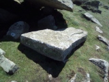

<< Our Photo Pages >> Fauteuil de César - Rock Cut Tomb in France in Midi:Lot (46)
Submitted by TheCaptain on Wednesday, 19 January 2011 Page Views: 2650
Multi-periodSite Name: Fauteuil de CésarCountry: France Département: Midi:Lot (46) Type: Rock Cut Tomb
Nearest Town: Cahors Nearest Village: Prayssac
Latitude: 44.515300N Longitude: 1.212800E
Condition:
| 5 | Perfect |
| 4 | Almost Perfect |
| 3 | Reasonable but with some damage |
| 2 | Ruined but still recognisable as an ancient site |
| 1 | Pretty much destroyed, possibly visible as crop marks |
| 0 | No data. |
| -1 | Completely destroyed |
| 5 | Superb |
| 4 | Good |
| 3 | Ordinary |
| 2 | Not Good |
| 1 | Awful |
| 0 | No data. |
| 5 | Can be driven to, probably with disabled access |
| 4 | Short walk on a footpath |
| 3 | Requiring a bit more of a walk |
| 2 | A long walk |
| 1 | In the middle of nowhere, a nightmare to find |
| 0 | No data. |
| 5 | co-ordinates taken by GPS or official recorded co-ordinates |
| 4 | co-ordinates scaled from a detailed map |
| 3 | co-ordinates scaled from a bad map |
| 2 | co-ordinates of the nearest village |
| 1 | co-ordinates of the nearest town |
| 0 | no data |
Internal Links:
External Links:
I have visited· I would like to visit
johnstone visited on 29th Aug 2018 - their rating: Cond: 3 Amb: 3 Access: 3
regina have visited here
")
You may be viewing yesterday's version of this page. To see the most up to date information please register for a free account.
")
")
")
")
Do not use the above information on other web sites or publications without permission of the contributor.
Nearby Images from Flickr


The above images may not be of the site on this page, but were taken nearby. They are loaded from Flickr so please click on them for image credits.
Click here to see more info for this site
Nearby sites
Click here to view sites on an interactive map of the areaKey: Red: member's photo, Blue: 3rd party photo, Yellow: other image, Green: no photo - please go there and take one, Grey: site destroyed
Download sites to:
KML (Google Earth)
GPX (GPS waypoints)
CSV (Garmin/Navman)
CSV (Excel)
To unlock full downloads you need to sign up as a Contributory Member. Otherwise downloads are limited to 50 sites.
Turn off the page maps and other distractions
Nearby sites listing. In the following links * = Image available
512m E 97° Dolmen des Las Tres Peyres* Burial Chamber or Dolmen
697m E 96° Dolmen dit los Tres Peyres* Burial Chamber or Dolmen
1.0km NE 44° Le chaos de Roquebert* Rock Outcrop
1.5km NNE 18° La Bertrandoune Dolmen* Burial Chamber or Dolmen
2.0km N 10° Les Trois Pierres (Les Junies)* Burial Chamber or Dolmen
3.2km NE 34° Dolmen de la Baune Burial Chamber or Dolmen
5.7km N 2° Dolmen des Trois Pierres Burial Chamber or Dolmen
6.4km ESE 119° Luzech Oppidum Ancient Village or Settlement
8.7km SE 143° Menhir La Pierre Longue (Foussal)* Modern Stone Circle etc
9.0km SE 144° Menhir de la Pierre Levée (Saint-Vincent)* Standing Stone (Menhir)
9.3km NE 50° Menhir de Courtis* Standing Stone (Menhir)
11.1km NNW 337° Dolmen dit les Pierres du Loup Burial Chamber or Dolmen
11.5km NNE 30° Peyrefiche Standing Stones
12.0km SW 225° Garroustes Dolmen* Burial Chamber or Dolmen
13.2km W 280° Abri du Roc de Cavart Cave or Rock Shelter
13.3km SW 235° Dolmen de Bartassou Burial Chamber or Dolmen
13.6km NNE 30° Dolmen de Touron Burial Chamber or Dolmen
13.8km NNE 32° Dolmen de Surgès Burial Chamber or Dolmen
16.5km S 186° Dolmen de Roland Burial Chamber or Dolmen
16.6km S 185° Grotte de Roland Cave or Rock Shelter
17.7km NW 306° Source des 3 Évêques* Holy Well or Sacred Spring
18.2km NNW 333° Roc Travers* Natural Stone / Erratic / Other Natural Feature
18.4km NNW 332° Cromlech de Besse 1* Stone Circle
19.2km ESE 115° Fontaine des Chartreux* Holy Well or Sacred Spring
19.3km SE 142° Peyre Levade (Labastide Marnhac)* Burial Chamber or Dolmen
View more nearby sites and additional images


 We would like to know more about this location. Please feel free to add a brief description and any relevant information in your own language.
 Wir möchten mehr über diese Stätte erfahren. Bitte zögern Sie nicht, eine kurze Beschreibung und relevante Informationen in Deutsch hinzuzufügen.
 Nous aimerions en savoir encore un peu sur les lieux. S'il vous plaît n'hesitez pas à ajouter une courte description et tous les renseignements pertinents dans votre propre langue.
 Quisieramos informarnos un poco más de las lugares. No dude en añadir una breve descripción y otros datos relevantes en su propio idioma.