
, Aubrey Burl")
<< Our Photo Pages >> Knowe of Ramsay - Chambered Cairn in Scotland in Orkney
Submitted by DrewParsons on Saturday, 16 October 2010 Page Views: 6502
Neolithic and Bronze AgeSite Name: Knowe of RamsayCountry: Scotland County: Orkney Type: Chambered Cairn
Nearest Town: Rousay Island Nearest Village: Brinian
Map Ref: HY40042800
Latitude: 59.134562N Longitude: 3.04948W
Condition:
| 5 | Perfect |
| 4 | Almost Perfect |
| 3 | Reasonable but with some damage |
| 2 | Ruined but still recognisable as an ancient site |
| 1 | Pretty much destroyed, possibly visible as crop marks |
| 0 | No data. |
| -1 | Completely destroyed |
| 5 | Superb |
| 4 | Good |
| 3 | Ordinary |
| 2 | Not Good |
| 1 | Awful |
| 0 | No data. |
| 5 | Can be driven to, probably with disabled access |
| 4 | Short walk on a footpath |
| 3 | Requiring a bit more of a walk |
| 2 | A long walk |
| 1 | In the middle of nowhere, a nightmare to find |
| 0 | No data. |
| 5 | co-ordinates taken by GPS or official recorded co-ordinates |
| 4 | co-ordinates scaled from a detailed map |
| 3 | co-ordinates scaled from a bad map |
| 2 | co-ordinates of the nearest village |
| 1 | co-ordinates of the nearest town |
| 0 | no data |
Internal Links:
External Links:
I have visited· I would like to visit
drolaf visited on 9th Jun 2022 - their rating: Cond: 2 Amb: 4 Access: 3
DrewParsons have visited here
")
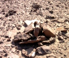
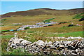
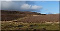
This cairn is one of a series set along a ridge on the south side of Rousay Island overlooking Eynhallow Sound and Mainland. It was excavated in 1935. The excavators found that much of the stonework had been robbed for local building purposes over the years and all that remained was a mound some 1.5 metres high and 33 metres long covered in grass. Some slabs were found near the summit indicating that the site was another stalled cairn similar to the nearby Knowe of Yarso. The entrance passage led to a narrow chamber 26 metres long divided into 14 stalls by upright stones. Near the south west corner of stall 5 a small cist with no remains in it was found. The outer walls had a plain construction without the patterned style seen at nearby Yarso and Blackhammer cairns. There were signs of burning in stalls 6 though to 11 although very few finds were made. These included half a dozen sherds of reddish pottery, six pieces of flint, a poorly made scraper, and other flint flakes. The human remains were poorly preserved - an adult from cell 3, an elderly male from cell 5 and two fragments of an arm and a leg in cell 8. Some of the human bones as well as some of the animal and bird bones also found showed signs of scorching. The animal and bird bones included red-deer, sheep, ox, great auk, bittern, comorant, curlew, duck, white tailed eagle, pink footed goose and in the fish department, a conger eel!
To reach the cairn follow the somewhat indistinct trail west from the Knowe of Yarso and contour down until you pass a ruined farm house keeping an eye out for the mound below you. My GPS coordinates were 59.13460N and -03.04944W right at the site. I was unable to locate an entrance and given the description of the state of the site by the excavators I suppose that it is now inaccessible.
Reference: A Stalled Chambered Cairn, Knowe of Ramsay, J Graham Callander Director of the National Museum of Antiquities of Scotland, and Walter Grant. Proceedings of the Society May 11 1936
You may be viewing yesterday's version of this page. To see the most up to date information please register for a free account.
")
")
")
")
Do not use the above information on other web sites or publications without permission of the contributor.
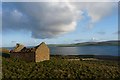
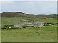
Nearby Images from Geograph Britain and Ireland:
©2012(licence)
©2012(licence)
©2021(licence)
©2009(licence)
©2012(licence)
The above images may not be of the site on this page, they are loaded from Geograph.
Please Submit an Image of this site or go out and take one for us!
Click here to see more info for this site
Nearby sites
Key: Red: member's photo, Blue: 3rd party photo, Yellow: other image, Green: no photo - please go there and take one, Grey: site destroyed
Download sites to:
KML (Google Earth)
GPX (GPS waypoints)
CSV (Garmin/Navman)
CSV (Excel)
To unlock full downloads you need to sign up as a Contributory Member. Otherwise downloads are limited to 50 sites.
Turn off the page maps and other distractions
Nearby sites listing. In the following links * = Image available
126m WSW 251° Knowe of Lairo* Chambered Cairn (HY39922796)
441m E 96° Knowe of Yarso* Chambered Cairn (HY40482795)
550m S 177° Knowe of Burrian (Frotoft)* Broch or Nuraghe (HY40062745)
615m SE 143° Langstane (Orkney)* Standing Stone (Menhir) (HY404275)
843m W 276° Viera Lodge Broch or Nuraghe (HY392281)
1.4km ESE 105° Blackhammer* Chambered Tomb (HY41422761)
1.6km ESE 118° Knowe of Hunclett* Broch or Nuraghe (HY41442722)
1.9km WNW 300° Westness Chambererd Tomb* Chambered Tomb (HY38402898)
2.2km WSW 237° Gurness* Broch or Nuraghe (HY3818926842)
2.2km WSW 237° Aikerness Class I Pictish Symbol Stone (HY38182685)
2.6km E 98° Taversoe Tuick* Chambered Cairn (HY42572761)
2.7km ENE 66° Tammaskirk* Ancient Village or Settlement (HY42502907)
3.0km WNW 303° Knowe of Swandro* Chambered Cairn (HY37532966)
3.1km S 179° Ness of Woodwick* Broch or Nuraghe (HY40072487)
3.2km WNW 302° Knowe of Rowiegar* Chambered Cairn (HY37332978)
3.7km SW 216° Quoys Chambered Cairn Chambered Cairn (HY37822507)
3.8km SSW 212° Redland South* Chambered Cairn (HY38002484)
3.8km NW 311° Midhowe Chambered Cairn* Chambered Cairn (HY37223051)
3.8km NW 312° Midhowe Broch* Broch or Nuraghe (HY372306)
3.8km WSW 250° Knowe of Stenso* Broch or Nuraghe (HY3639426747)
3.9km E 89° Cubbie Roo's Burden* Chambered Cairn (HY43932800)
4.0km NNE 28° Knowe of Craie* Chambered Cairn (HY41963153)
4.0km NW 311° North Howe Broch* Broch or Nuraghe (HY3705130722)
4.4km N 354° Knowe of Lingro Cairn (HY3964832378)
4.4km S 182° Knowe of Midgarth* Ancient Village or Settlement (HY39812361)
View more nearby sites and additional images


 We would like to know more about this location. Please feel free to add a brief description and any relevant information in your own language.
 Wir möchten mehr über diese Stätte erfahren. Bitte zögern Sie nicht, eine kurze Beschreibung und relevante Informationen in Deutsch hinzuzufügen.
 Nous aimerions en savoir encore un peu sur les lieux. S'il vous plaît n'hesitez pas à ajouter une courte description et tous les renseignements pertinents dans votre propre langue.
 Quisieramos informarnos un poco más de las lugares. No dude en añadir una breve descripción y otros datos relevantes en su propio idioma.