


<< Our Photo Pages >> Brynaman - Rock Art in Wales in Carmarthenshire
Submitted by sem on Friday, 08 October 2010 Page Views: 6102
Rock ArtSite Name: BrynamanCountry: Wales County: Carmarthenshire Type: Rock Art
Map Ref: SN7146518453
Latitude: 51.849829N Longitude: 3.867499W
Condition:
| 5 | Perfect |
| 4 | Almost Perfect |
| 3 | Reasonable but with some damage |
| 2 | Ruined but still recognisable as an ancient site |
| 1 | Pretty much destroyed, possibly visible as crop marks |
| 0 | No data. |
| -1 | Completely destroyed |
| 5 | Superb |
| 4 | Good |
| 3 | Ordinary |
| 2 | Not Good |
| 1 | Awful |
| 0 | No data. |
| 5 | Can be driven to, probably with disabled access |
| 4 | Short walk on a footpath |
| 3 | Requiring a bit more of a walk |
| 2 | A long walk |
| 1 | In the middle of nowhere, a nightmare to find |
| 0 | No data. |
| 5 | co-ordinates taken by GPS or official recorded co-ordinates |
| 4 | co-ordinates scaled from a detailed map |
| 3 | co-ordinates scaled from a bad map |
| 2 | co-ordinates of the nearest village |
| 1 | co-ordinates of the nearest town |
| 0 | no data |
Be the first person to rate this site - see the 'Contribute!' box in the right hand menu.
Internal Links:
External Links:
I have visited· I would like to visit
sem has visited here
")
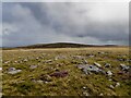
The stone in question lies close to and in view of Tair Carn Uchaff and Carn Pen-y-Clogau at grid ref SN 71465 18453 in Carmarthenshire.
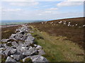
For anyone familiar with my Secret Signs theory (ie stones were placed to be easily distinguished from their natural surroundings) this is a good example. Both the stone itself and those nearby have all been bleached by peat (see Brynaman1) and appear to have been brought
from a peat bog about 400yds away.
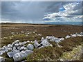
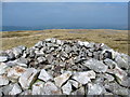
The stone in question is diamond shaped and measures a uniform 17” by 17” across its points (see Brynaman 2). In the centre are two cup marks – whether these are natural solution holes or man-made, I don't know. However, their significance becomes clear when you sight along the points of the rock at a compass angle of 245deg, two of the three cairns of Tair Carn Uchaf are very prominent on the horizon (see Brynaman 3). Another interesting thing is that the rock appears to have been shaped like a swallow-tail when looking at this angle ie it has two points
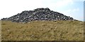
Looking in the reverse direction gives a view of Carn Pen-y-Clogau (see Brynaman 4) at a compass angle of 55deg and at this angle the rock has only one point. Maybe I am reading too much into this, but one point for one cairn and two points for two appears to be more than a coincidence.
The fact that this stone does not lie in a direct line between the cairns may also be significant.
You may be viewing yesterday's version of this page. To see the most up to date information please register for a free account.
")
")
")
Do not use the above information on other web sites or publications without permission of the contributor.
Nearby Images from Geograph Britain and Ireland:
©2011(licence)
©2020(licence)
©2014(licence)
©2014(licence)
©2023(licence)
The above images may not be of the site on this page, they are loaded from Geograph.
Please Submit an Image of this site or go out and take one for us!
Click here to see more info for this site
Nearby sites
Key: Red: member's photo, Blue: 3rd party photo, Yellow: other image, Green: no photo - please go there and take one, Grey: site destroyed
Download sites to:
KML (Google Earth)
GPX (GPS waypoints)
CSV (Garmin/Navman)
CSV (Excel)
To unlock full downloads you need to sign up as a Contributory Member. Otherwise downloads are limited to 50 sites.
Turn off the page maps and other distractions
Nearby sites listing. In the following links * = Image available
271m ENE 58° Carn Pen-y-Clogau* Cairn (SN71701859)
742m SSE 158° Garreg Fraith* Cairn (SN7172117756)
1.4km ENE 69° Carn Pen Rhiw Ddu* Cairn (SN72751890)
2.2km E 80° Foel Fawr Cairn* Cairn (SN7361518783)
2.3km E 97° Garreg Lwyd Marker Stone* Natural Stone / Erratic / Other Natural Feature (SN73731810)
2.5km WSW 243° Tair Carn Uchaf* Cairn (SN69211737)
2.6km E 100° Garreg Lwyd Cairn* Cairn (SN74041793)
2.6km W 261° Banc Wernwgan Boundary Stone* Marker Stone (SN68851811)
2.7km E 81° Nant Oesglyn Cairn* Cairn (SN74131882)
2.7km SSW 199° Deg Arbedd* Cairn (SN70501591)
2.8km E 80° Moel Gornach Cairn I* Cairn (SN74231886)
3.5km W 270° Hen Grofft* Round Barrow(s) (SN67931853)
3.6km WSW 240° Tair Carn Isaf* Cairn (SN68331674)
4.7km W 276° Carreg Cennen Cave* Cave or Rock Shelter (SN6683819064)
4.8km NNW 340° Trichrug* Cairn (SN69962298)
4.8km NNE 27° Coitan Arthur Natural Stone / Erratic / Other Natural Feature (SN738227)
5.1km WSW 238° Banc Crucorfod Round Cairn* Round Cairn (SN67021587)
5.3km E 95° Nant-y-Llyn (Carmarthenshire)* Standing Stone (Menhir) (SN76701784)
5.5km ESE 102° Carn Fadog* Cairn (SN76861721)
5.9km NW 311° Sythfaen (Carmarthenshire)* Standing Stone (Menhir) (SN67052245)
6.1km NNW 339° Carn Goch Cairn* Cairn (SN6942924253)
6.2km WSW 258° Carregdwfn Round Cairn* Cairn (SN65371736)
6.2km WSW 240° Pen-y-Coed Maen Hir* Standing Stone (Menhir) (SN66011548)
6.2km WSW 240° Penyrheolddu Ring Cairn* Ring Cairn (SN65991548)
6.2km WSW 240° Penyrheolddu Standing Stone* Standing Stone (Menhir) (SN65971547)
View more nearby sites and additional images


 We would like to know more about this location. Please feel free to add a brief description and any relevant information in your own language.
 Wir möchten mehr über diese Stätte erfahren. Bitte zögern Sie nicht, eine kurze Beschreibung und relevante Informationen in Deutsch hinzuzufügen.
 Nous aimerions en savoir encore un peu sur les lieux. S'il vous plaît n'hesitez pas à ajouter une courte description et tous les renseignements pertinents dans votre propre langue.
 Quisieramos informarnos un poco más de las lugares. No dude en añadir una breve descripción y otros datos relevantes en su propio idioma.