


<< Our Photo Pages >> Drangstedt Steingrab 2 - Long Barrow in Germany in Lower Saxony, Bremen
Submitted by Martin_L on Friday, 21 May 2010 Page Views: 2484
Neolithic and Bronze AgeSite Name: Drangstedt Steingrab 2 Alternative Name: Sprockhoff 613, Drangstedt Hünenbett IICountry: Germany Land: Lower Saxony, Bremen Type: Long Barrow
Nearest Town: Bremerhaven Nearest Village: Drangstedt
Latitude: 53.617570N Longitude: 8.703330E
Condition:
| 5 | Perfect |
| 4 | Almost Perfect |
| 3 | Reasonable but with some damage |
| 2 | Ruined but still recognisable as an ancient site |
| 1 | Pretty much destroyed, possibly visible as crop marks |
| 0 | No data. |
| -1 | Completely destroyed |
| 5 | Superb |
| 4 | Good |
| 3 | Ordinary |
| 2 | Not Good |
| 1 | Awful |
| 0 | No data. |
| 5 | Can be driven to, probably with disabled access |
| 4 | Short walk on a footpath |
| 3 | Requiring a bit more of a walk |
| 2 | A long walk |
| 1 | In the middle of nowhere, a nightmare to find |
| 0 | No data. |
| 5 | co-ordinates taken by GPS or official recorded co-ordinates |
| 4 | co-ordinates scaled from a detailed map |
| 3 | co-ordinates scaled from a bad map |
| 2 | co-ordinates of the nearest village |
| 1 | co-ordinates of the nearest town |
| 0 | no data |
Internal Links:
External Links:
I have visited· I would like to visit
Martin_L has visited here
")
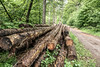
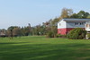
There are two funnel shaped pits inside the barrow probably indicating the positions of the chambers. A smaller one is located at 55m-60m (measuring from the West), the other between 70m and 80m. Granite fragments can be found in these pits and at other parts of the barrow. To get an impression how the site originally may have looked compare with similar sites in Germany and Denmark in better condition. For example: Kleinenkneter Steine ,Karlsminde, Grønsalen
The stones probably were destroyed by explosives in the 19th century and may have been used as building material for the nearby road or the now abandoned railway 100m to the South(*) .
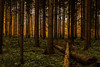
It is part of a large Necropolis consisting of at least two other neolithic chambered long-barrows just to the South and at least one further neolithic chambered long-barrow some hundred meters to the East. The use of this area as a cemetery continued in the bronze-age. Several barrows and barrow cemeteries are located nearby.
All of these sites are not signposted, but often small red-painted wooden poles are used to indicate them for the forest workers.
Unfortunately this site and its neighbours Drangstedt Steingrab I and III recently were damaged by illegal (it looks so unprofessional it cannot be the work of archaeologists) excavations. I detected this in May 2010 and the digging marks (probably resulting from a spade) were very clear so i assume the crime took place in the previous weeks. This really is silly as there are no precious things to be found in the tombs, especially when (like in this case) the chamber is completely robbed. On account of this i decided to publish the sites at the MP so that other archaeologically interested people may visit and have a look to prevent further damage.
Reference: Sprockhoff, Schwieger in: Körner, G. (Ed.), Sprockhoff, E. Atlas der Megalithgräber Deutschlands, Teil 3: Niedersachsen-Westfalen, Habelt, Bonn, 1975, p. 6
(*)There is no reference for this, but it is reported from other sites. The reason is the lack of bedrock/quarries in these areas, so stones were rare and only available as glacial erratics. As a result most megalithic tombs were used as quarries....
You may be viewing yesterday's version of this page. To see the most up to date information please register for a free account.
")
")
")
Do not use the above information on other web sites or publications without permission of the contributor.
Nearby Images from Flickr

The above images may not be of the site on this page, but were taken nearby. They are loaded from Flickr so please click on them for image credits.
Click here to see more info for this site
Nearby sites
Click here to view sites on an interactive map of the areaKey: Red: member's photo, Blue: 3rd party photo, Yellow: other image, Green: no photo - please go there and take one, Grey: site destroyed
Download sites to:
KML (Google Earth)
GPX (GPS waypoints)
CSV (Garmin/Navman)
CSV (Excel)
To unlock full downloads you need to sign up as a Contributory Member. Otherwise downloads are limited to 50 sites.
Turn off the page maps and other distractions
Nearby sites listing. In the following links * = Image available
49m NNE 17° Drangstedt Steingrab 1* Long Barrow
60m SW 220° Drangstedt Steingrab 3* Long Barrow
218m ENE 76° Drangstedt Steingrab 5* Long Barrow
1.2km ESE 110° Drangstedt Grab 4* Chambered Tomb
1.8km WNW 282° Debstedt-Ost Huegelgrab (1)* Round Barrow(s)
2.7km WSW 238° Wehden Steingrab* Passage Grave
5.3km NW 320° Siebenbergensheide* Barrow Cemetery
5.7km WNW 285° Bullmersberg* Hillfort
6.1km NNE 31° Stueh Huegelgrab (1) Round Barrow(s)
6.3km NE 43° Floegelner Holz Huegelgrab (1) Round Barrow(s)
6.3km WSW 238° Rillenstein Leherheide* Sculptured Stone
6.4km WNW 297° Grapenberg* Round Barrow(s)
6.4km NE 46° Floegelner Holz Huegelgrab (2) Round Barrow(s)
6.5km NE 34° Stueh Huegelgrab (2) Round Barrow(s)
6.6km NE 43° Floegeln Steinkistengrab* Cist
6.6km ENE 60° Floegeln Steingrab 1* Passage Grave
6.6km ENE 60° Floegeln Grabhuegelgruppe (Floegeln 3)* Barrow Cemetery
6.6km ENE 61° Floegeln Steingrab 2* Passage Grave
6.7km ENE 60° Floegeln Vorgeschichtspfad* Museum
6.8km NW 309° Heidenschanze* Misc. Earthwork
6.9km NW 315° Heidenstadt* Misc. Earthwork
7.0km NW 310° Sievern Huegelgraeberfeld (1)* Barrow Cemetery
7.0km NE 44° Haselhoern Huegelgrab (1)* Round Barrow(s)
7.1km NNE 32° Flögeln-Eekhöltjen* Ancient Village or Settlement
7.2km NW 308° Sievern Grabhügel (4)* Round Barrow(s)
View more nearby sites and additional images


 We would like to know more about this location. Please feel free to add a brief description and any relevant information in your own language.
 Wir möchten mehr über diese Stätte erfahren. Bitte zögern Sie nicht, eine kurze Beschreibung und relevante Informationen in Deutsch hinzuzufügen.
 Nous aimerions en savoir encore un peu sur les lieux. S'il vous plaît n'hesitez pas à ajouter une courte description et tous les renseignements pertinents dans votre propre langue.
 Quisieramos informarnos un poco más de las lugares. No dude en añadir una breve descripción y otros datos relevantes en su propio idioma.