

<< Other Photo Pages >> Callanish 16 - Standing Stone (Menhir) in Scotland in Isle of Lewis
Submitted by Anonymous on Tuesday, 17 April 2001 Page Views: 6900
Neolithic and Bronze AgeSite Name: Callanish 16Country: Scotland County: Isle of Lewis Type: Standing Stone (Menhir)
Nearest Town: Stornoway Nearest Village: Callanish
Map Ref: NB213338 Landranger Map Number: 8
Latitude: 58.204580N Longitude: 6.746045W
Condition:
| 5 | Perfect |
| 4 | Almost Perfect |
| 3 | Reasonable but with some damage |
| 2 | Ruined but still recognisable as an ancient site |
| 1 | Pretty much destroyed, possibly visible as crop marks |
| 0 | No data. |
| -1 | Completely destroyed |
| 5 | Superb |
| 4 | Good |
| 3 | Ordinary |
| 2 | Not Good |
| 1 | Awful |
| 0 | No data. |
| 5 | Can be driven to, probably with disabled access |
| 4 | Short walk on a footpath |
| 3 | Requiring a bit more of a walk |
| 2 | A long walk |
| 1 | In the middle of nowhere, a nightmare to find |
| 0 | No data. |
| 5 | co-ordinates taken by GPS or official recorded co-ordinates |
| 4 | co-ordinates scaled from a detailed map |
| 3 | co-ordinates scaled from a bad map |
| 2 | co-ordinates of the nearest village |
| 1 | co-ordinates of the nearest town |
| 0 | no data |
Internal Links:
External Links:
")
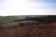
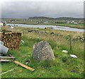
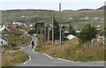
Local traditions encourage the idea that the stone is an ancient feature. Its position is very interesting as it is 800 metres from the central stone at the main site; at an azimuth of just 1°, it is very close to due north and is in direct line with the central megalith and the south row. As seen from this stone, the moon would have transitted low over the horizon when at its southernmost extreme. This would have been a spectacular sight, with the main site semi-silhouetted by the moonlight. The photograph shows the view concerned, which is now confused by houses and poles.
There are two other stones within about 20 metres. One is in the line of a wall, so may be modern. The other is almost buried by peaty soil, within the
http://home.clara.net/gponting/
Canmore site no. 4160.
You may be viewing yesterday's version of this page. To see the most up to date information please register for a free account.
Do not use the above information on other web sites or publications without permission of the contributor.
davidmorgan has found this location on Google Street View:
Nearby Images from Geograph Britain and Ireland:
©2019(licence)
©2005(licence)
©2005(licence)
©2007(licence)
©2010(licence)
The above images may not be of the site on this page, they are loaded from Geograph.
Please Submit an Image of this site or go out and take one for us!
Click here to see more info for this site
Nearby sites
Key: Red: member's photo, Blue: 3rd party photo, Yellow: other image, Green: no photo - please go there and take one, Grey: site destroyed
Download sites to:
KML (Google Earth)
GPX (GPS waypoints)
CSV (Garmin/Navman)
CSV (Excel)
To unlock full downloads you need to sign up as a Contributory Member. Otherwise downloads are limited to 50 sites.
![]()
![]()
Turn off the page maps and other distractions
Nearby sites listing. In the following links * = Image available
360m NNE 30° Callanish 13* Standing Stones (NB215341)
785m S 176° Callanish* Stone Circle (NB2129833013)
789m S 177° Callanish I* Stone Circle (NB2128633009)
858m SE 140° Callanish 19* Stone Circle (NB218331)
1.1km NNE 24° Olcote Kerbed Cairn* Cairn (NB2179634733)
1.2km N 8° Callanish 12* Standing Stone (Menhir) (NB2155634967)
1.5km SE 138° Callanish 2* Stone Circle (NB2221432614)
1.6km SE 141° Loch Roag Timber Circle (NB222325)
1.6km SE 128° Callanish 3* Stone Circle (NB2251532710)
1.7km E 92° Callanish 10* Stone Circle (NB22973362)
1.7km N 349° Cnoc a Phrionnsa* Chambered Cairn (NB211355)
1.7km ESE 117° Callanish 14* Standing Stone (Menhir) (NB228329)
2.1km NNE 22° Callanish 11* Standing Stone (Menhir) (NB22233569)
2.2km SE 137° Cnoc Fillibhir Mhor* Stone Row / Alignment (NB22683207)
3.0km ESE 123° Callanish 17* Stone Circle (NB237320)
3.7km W 277° Callanish 15* Standing Stone (Menhir) (NB177345)
3.8km SSE 150° Callanish 4* Stone Circle (NB2298830412)
4.1km SSE 148° Callanish 7* Ancient Mine, Quarry or other Industry (NB232302)
4.4km SSE 147° Callanish 5* Stone Row / Alignment (NB23432990)
4.5km W 273° Dun Barraglom Broch or Nuraghe (NB16773435)
4.5km SSE 150° Callanish 9* Standing Stones (NB233297)
4.6km W 272° Barraglom Cup-Marked Rock Rock Art (NB167343)
4.8km W 268° Callanish 8A* Standing Stone (Menhir) (NB165340)
4.8km SE 132° Callanish 6* Standing Stones (NB24653034)
4.9km W 271° Callanish 8* Stone Circle (NB16423424)
View more nearby sites and additional images


 We would like to know more about this location. Please feel free to add a brief description and any relevant information in your own language.
 Wir möchten mehr über diese Stätte erfahren. Bitte zögern Sie nicht, eine kurze Beschreibung und relevante Informationen in Deutsch hinzuzufügen.
 Nous aimerions en savoir encore un peu sur les lieux. S'il vous plaît n'hesitez pas à ajouter une courte description et tous les renseignements pertinents dans votre propre langue.
 Quisieramos informarnos un poco más de las lugares. No dude en añadir una breve descripción y otros datos relevantes en su propio idioma.