


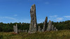
<< Our Photo Pages >> Blomsholm standing stones - Standing Stones in Sweden in Bohuslän
Submitted by Aska on Thursday, 04 September 2008 Page Views: 6022
Neolithic and Bronze AgeSite Name: Blomsholm standing stonesCountry: Sweden Landskap: Bohuslän Type: Standing Stones
Nearest Town: Strömstad Nearest Village: Blomsholm
Latitude: 58.976700N Longitude: 11.249450E
Condition:
| 5 | Perfect |
| 4 | Almost Perfect |
| 3 | Reasonable but with some damage |
| 2 | Ruined but still recognisable as an ancient site |
| 1 | Pretty much destroyed, possibly visible as crop marks |
| 0 | No data. |
| -1 | Completely destroyed |
| 5 | Superb |
| 4 | Good |
| 3 | Ordinary |
| 2 | Not Good |
| 1 | Awful |
| 0 | No data. |
| 5 | Can be driven to, probably with disabled access |
| 4 | Short walk on a footpath |
| 3 | Requiring a bit more of a walk |
| 2 | A long walk |
| 1 | In the middle of nowhere, a nightmare to find |
| 0 | No data. |
| 5 | co-ordinates taken by GPS or official recorded co-ordinates |
| 4 | co-ordinates scaled from a detailed map |
| 3 | co-ordinates scaled from a bad map |
| 2 | co-ordinates of the nearest village |
| 1 | co-ordinates of the nearest town |
| 0 | no data |
Internal Links:
External Links:
I have visited· I would like to visit
CharcoalBurner89 visited on 20th Aug 2023 - their rating: Cond: 4 Amb: 4 Access: 4 Clearly visible before reaching the stone circle. Both stones probably served either as "gates" or as tombstones / Bautastein.
ShamrockStone have visited here
")
You may be viewing yesterday's version of this page. To see the most up to date information please register for a free account.
")
")
")
")
Do not use the above information on other web sites or publications without permission of the contributor.
Nearby Images from Flickr
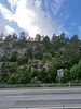
The above images may not be of the site on this page, but were taken nearby. They are loaded from Flickr so please click on them for image credits.
Click here to see more info for this site
Nearby sites
Click here to view sites on an interactive map of the areaKey: Red: member's photo, Blue: 3rd party photo, Yellow: other image, Green: no photo - please go there and take one, Grey: site destroyed
Download sites to:
KML (Google Earth)
GPX (GPS waypoints)
CSV (Garmin/Navman)
CSV (Excel)
To unlock full downloads you need to sign up as a Contributory Member. Otherwise downloads are limited to 50 sites.
Turn off the page maps and other distractions
Nearby sites listing. In the following links * = Image available
139m NW 323° Blomsholm stone circle* Stone Circle
299m S 184° Blomsholm Skeppsättning* Standing Stones
1.6km SSW 201° Grönehøg Gravfält* Barrow Cemetery
4.3km ESE 116° Massleberg Gravfält* Barrow Cemetery
4.3km ESE 115° Massleberg Passage Grave* Passage Grave
4.3km ESE 104° Massleberg - Skee 622:1* Rock Art
4.4km E 96° Jörlov Hällristningar* Rock Art
4.4km ESE 116° Massleberg Hällristning* Carving
6.9km SE 144° Dårskilds Högar* Stone Circle
9.3km NNW 347° Torp Hällristning* Carving
17.4km NE 39° Åskasa* Barrow Cemetery
18.1km NNE 12° Bautastein (Halden)* Standing Stone (Menhir)
18.9km NNE 32° Harekasfjellet* Hillfort
18.9km N 0° Jellhaugen Mound* Round Barrow(s)
19.4km N 3° Vestre Huseby* Barrow Cemetery
19.5km N 0° Alkerød* Rock Art
19.6km N 359° Hjelmungen* Rock Art
20.5km N 2° Kongeveien-Tingstedet* Stone Circle
20.6km N 2° Tingstedet-Ekås* Stone Circle
21.0km NNW 331° Langvika-Slottsåsen* Hillfort
22.3km N 358° Bissebergkasa* Stone Circle
22.4km NNW 337° Thorsø Runestones* Carving
23.8km NNW 344° Røaborgen* Hillfort
23.9km NNE 15° Tre Furuer* Barrow Cemetery
24.1km NNE 14° Rokke barrow cemetery* Barrow Cemetery
View more nearby sites and additional images


 We would like to know more about this location. Please feel free to add a brief description and any relevant information in your own language.
 Wir möchten mehr über diese Stätte erfahren. Bitte zögern Sie nicht, eine kurze Beschreibung und relevante Informationen in Deutsch hinzuzufügen.
 Nous aimerions en savoir encore un peu sur les lieux. S'il vous plaît n'hesitez pas à ajouter une courte description et tous les renseignements pertinents dans votre propre langue.
 Quisieramos informarnos un poco más de las lugares. No dude en añadir una breve descripción y otros datos relevantes en su propio idioma.