

<< Our Photo Pages >> Menhir des Ouches - Standing Stone (Menhir) in France in Pays de la Loire:Vendée (85)
Submitted by dt44 on Sunday, 16 March 2008 Page Views: 3436
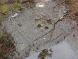
Neolithic and Bronze AgeSite Name: Menhir des Ouches Alternative Name: Site FrébouchèreCountry: France Département: Pays de la Loire:Vendée (85) Type: Standing Stone (Menhir)
Nearest Town: Les Sables d'Olonne Nearest Village: Le Bernard
Latitude: 46.449200N Longitude: 1.4669W
Condition:
| 5 | Perfect |
| 4 | Almost Perfect |
| 3 | Reasonable but with some damage |
| 2 | Ruined but still recognisable as an ancient site |
| 1 | Pretty much destroyed, possibly visible as crop marks |
| 0 | No data. |
| -1 | Completely destroyed |
| 5 | Superb |
| 4 | Good |
| 3 | Ordinary |
| 2 | Not Good |
| 1 | Awful |
| 0 | No data. |
| 5 | Can be driven to, probably with disabled access |
| 4 | Short walk on a footpath |
| 3 | Requiring a bit more of a walk |
| 2 | A long walk |
| 1 | In the middle of nowhere, a nightmare to find |
| 0 | No data. |
| 5 | co-ordinates taken by GPS or official recorded co-ordinates |
| 4 | co-ordinates scaled from a detailed map |
| 3 | co-ordinates scaled from a bad map |
| 2 | co-ordinates of the nearest village |
| 1 | co-ordinates of the nearest town |
| 0 | no data |
Internal Links:
External Links:
I have visited· I would like to visit
dt44 has visited here
")
B Poissonnier in "La Vendée préhistorique" thinks that these two standing stones are in relation with Dolmen Frébouchère.
You may be viewing yesterday's version of this page. To see the most up to date information please register for a free account.
Do not use the above information on other web sites or publications without permission of the contributor.
Nearby Images from Flickr
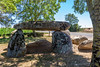
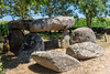
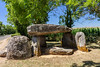
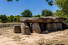
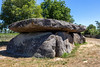
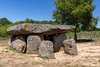
The above images may not be of the site on this page, but were taken nearby. They are loaded from Flickr so please click on them for image credits.
Click here to see more info for this site
Nearby sites
Click here to view sites on an interactive map of the areaKey: Red: member's photo, Blue: 3rd party photo, Yellow: other image, Green: no photo - please go there and take one, Grey: site destroyed
Download sites to:
KML (Google Earth)
GPX (GPS waypoints)
CSV (Garmin/Navman)
CSV (Excel)
To unlock full downloads you need to sign up as a Contributory Member. Otherwise downloads are limited to 50 sites.
Turn off the page maps and other distractions
Nearby sites listing. In the following links * = Image available
181m NNW 329° Menhir du Bois (Vendée)* Standing Stone (Menhir)
189m WSW 238° Frébouchère Dolmen* Burial Chamber or Dolmen
635m S 173° Dolmen de Savatole 3* Burial Chamber or Dolmen
644m SSE 162° Dolmen de Savatole 1* Burial Chamber or Dolmen
648m SSE 167° Dolmen de Savatole 2* Burial Chamber or Dolmen
1.1km S 183° Pierres Folles de la Serrée* Standing Stone (Menhir)
1.1km S 183° Menhir de Fontaines* Standing Stone (Menhir)
1.7km S 188° Pey du Rocher Burial Chamber or Dolmen
1.8km NW 312° Fontaine Saint Gré* Holy Well or Sacred Spring
1.9km NW 312° Fontaine Saint Gré tumulus* Chambered Cairn
1.9km NW 314° Fontaine Saint Gré menhirs* Standing Stones
1.9km ENE 61° Menhirs du Plessis* Standing Stones
2.0km E 85° Dolmen des Pierres Folles du Plessis* Burial Chamber or Dolmen
2.1km SSE 150° Cour du Breuil Dolmen* Burial Chamber or Dolmen
2.2km ENE 68° Dolmen de l'Echafaud du Plessis* Burial Chamber or Dolmen
2.2km ENE 70° Petit Menhir du Plessis* Standing Stone (Menhir)
2.3km NNW 328° Menhir de la Boilière* Standing Stone (Menhir)
2.8km NW 322° Menhir du Petit Saint Jean* Standing Stone (Menhir)
3.0km NW 313° Menhir du Restaurant* Standing Stone (Menhir)
3.1km NW 321° Pierres de Bel Air* Standing Stones
3.1km NW 315° Camp de César Menhir* Standing Stone (Menhir)
3.4km W 274° Créchaudes Dolmen* Burial Chamber or Dolmen
3.5km NNW 330° Puy Durand menhir* Standing Stone (Menhir)
3.5km W 281° La Sulette Dolmen* Burial Chamber or Dolmen
3.5km NW 310° Menhirs du Bois du Fourgon* Standing Stones
View more nearby sites and additional images


 We would like to know more about this location. Please feel free to add a brief description and any relevant information in your own language.
 Wir möchten mehr über diese Stätte erfahren. Bitte zögern Sie nicht, eine kurze Beschreibung und relevante Informationen in Deutsch hinzuzufügen.
 Nous aimerions en savoir encore un peu sur les lieux. S'il vous plaît n'hesitez pas à ajouter une courte description et tous les renseignements pertinents dans votre propre langue.
 Quisieramos informarnos un poco más de las lugares. No dude en añadir una breve descripción y otros datos relevantes en su propio idioma.