 with our Megalithic Portal iPhone app")


<< Our Photo Pages >> Broughwin IV - Multiple Stone Rows / Avenue in Scotland in Highlands
Submitted by SandG on Monday, 11 November 2002 Page Views: 4790
Neolithic and Bronze AgeSite Name: Broughwin IV Alternative Name: Broughwin SWCountry: Scotland County: Highlands Type: Multiple Stone Rows / Avenue
Nearest Town: Thurso Nearest Village: Ulbster / Whaligoe
Map Ref: ND3121541004 Landranger Map Number: 11
Latitude: 58.352105N Longitude: 3.176954W
Condition:
| 5 | Perfect |
| 4 | Almost Perfect |
| 3 | Reasonable but with some damage |
| 2 | Ruined but still recognisable as an ancient site |
| 1 | Pretty much destroyed, possibly visible as crop marks |
| 0 | No data. |
| -1 | Completely destroyed |
| 5 | Superb |
| 4 | Good |
| 3 | Ordinary |
| 2 | Not Good |
| 1 | Awful |
| 0 | No data. |
| 5 | Can be driven to, probably with disabled access |
| 4 | Short walk on a footpath |
| 3 | Requiring a bit more of a walk |
| 2 | A long walk |
| 1 | In the middle of nowhere, a nightmare to find |
| 0 | No data. |
| 5 | co-ordinates taken by GPS or official recorded co-ordinates |
| 4 | co-ordinates scaled from a detailed map |
| 3 | co-ordinates scaled from a bad map |
| 2 | co-ordinates of the nearest village |
| 1 | co-ordinates of the nearest town |
| 0 | no data |
Internal Links:
External Links:
I have visited· I would like to visit
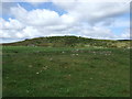
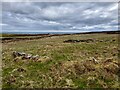
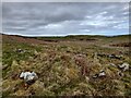
SandyG visited on 9th Aug 2014 - their rating: Cond: 1 Amb: 4 Access: 3 Car parking is available at ND 31885 40851. Follow the signposting to the Cairn O’Get. The stone row is situated about 320m to the south of the Cairn O’Get across uneven open moorland.
tom_bullock have visited here
")
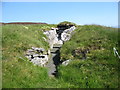
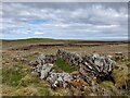
Update October 2019: Information about this stone row comes from the Stone Rows of Great Britain website - see their entry for Broughwhin IV, which was visited in June 2019, and includes a description, photographs of the alignment and some of the individual stones, plus access information and links to other online resources for more information.
The SRoGB tells us: "(this is) A single stone row measuring at least 20.9m long, including 5 small and medium-sized stones situated close to the crest of a steep west facing slope … The row forms part of a cluster including at least 10 stone rows near Loch Watenan and has definable visual links with the sea, nearby cairns, chambered cairns and stone rows".
The row is also recorded as part of Canmore ID 9017.
You may be viewing yesterday's version of this page. To see the most up to date information please register for a free account.
Do not use the above information on other web sites or publications without permission of the contributor.
Nearby Images from Geograph Britain and Ireland:
©2007(licence)
©2022(licence)
©2016(licence)
©2022(licence)
©2022(licence)
The above images may not be of the site on this page, they are loaded from Geograph.
Please Submit an Image of this site or go out and take one for us!
Click here to see more info for this site
Nearby sites
Key: Red: member's photo, Blue: 3rd party photo, Yellow: other image, Green: no photo - please go there and take one, Grey: site destroyed
Download sites to:
KML (Google Earth)
GPX (GPS waypoints)
CSV (Garmin/Navman)
CSV (Excel)
To unlock full downloads you need to sign up as a Contributory Member. Otherwise downloads are limited to 50 sites.
Turn off the page maps and other distractions
Nearby sites listing. In the following links * = Image available
55m SE 134° Broughwin II* Multiple Stone Rows / Avenue (ND3125440965)
163m NE 44° Cairn o'Get* Chambered Cairn (ND31334112)
218m SW 224° Cairn east of Cairn Hanach* Cairn (ND31064085)
234m SSW 208° Broughwin III* Stone Row / Alignment (ND3110040800)
236m NNE 22° Broughwin I* Multiple Stone Rows / Avenue (ND3130741222)
264m SW 233° Cairn Hanach* Chambered Cairn (ND31004085)
331m NNE 29° Garrywhin Multiple Stone Rows* Multiple Stone Rows / Avenue (ND3138241291)
349m NE 56° Watenan Farm* Multiple Stone Rows / Avenue (ND3150941193)
374m N 5° Garrywhin Fort* Hillfort (ND3125341377)
395m SSW 208° Groat’s Loch, South* Stone Row / Alignment (ND3102340658)
519m ENE 73° Watenan South Broch* Broch or Nuraghe (ND3171641147)
529m E 81° Loch Watenan* Multiple Stone Rows / Avenue (ND31744108)
571m S 175° Clash-an-dam* Stone Row / Alignment (ND3125640434)
741m NE 51° Watenan North Broch Broch or Nuraghe (ND3180441456)
892m WNW 283° Warehouse Hill Broch or Nuraghe (ND3034841227)
953m ENE 68° Marquel Stone Row / Alignment (ND32114134)
1.2km NNE 25° Watenan East* Stone Row / Alignment (ND31724204)
1.2km N 4° Watenan West* Stone Row / Alignment (ND31324218)
1.3km NNW 328° Warehouse South* Chambered Cairn (ND3057342081)
1.3km NNW 326° Warehouse West* Cairn (ND3050742107)
1.3km ENE 67° Ulbster School Broch or Nuraghe (ND3243141497)
1.4km NW 326° Warehouse Standing Stone* Standing Stone (Menhir) (ND3046242147)
1.4km NNW 332° Warehouse North* Chambered Cairn (ND3056742276)
1.5km NNW 327° Yarrows Fort* Hillfort (ND3041342265)
1.5km S 186° Bruan* Broch or Nuraghe (ND31023949)
View more nearby sites and additional images


 We would like to know more about this location. Please feel free to add a brief description and any relevant information in your own language.
 Wir möchten mehr über diese Stätte erfahren. Bitte zögern Sie nicht, eine kurze Beschreibung und relevante Informationen in Deutsch hinzuzufügen.
 Nous aimerions en savoir encore un peu sur les lieux. S'il vous plaît n'hesitez pas à ajouter une courte description et tous les renseignements pertinents dans votre propre langue.
 Quisieramos informarnos un poco más de las lugares. No dude en añadir una breve descripción y otros datos relevantes en su propio idioma.