

<< Our Photo Pages >> St Caffo (Llangaffo) - Ancient Cross in Wales in Anglesey
Submitted by TimPrevett on Thursday, 24 May 2007 Page Views: 8343
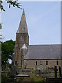
Early Medieval (Dark Age)Site Name: St Caffo (Llangaffo)Country: Wales County: Anglesey Type: Ancient Cross
Nearest Village: Llangaffo
Map Ref: SH446685
Latitude: 53.190820N Longitude: 4.327424W
Condition:
| 5 | Perfect |
| 4 | Almost Perfect |
| 3 | Reasonable but with some damage |
| 2 | Ruined but still recognisable as an ancient site |
| 1 | Pretty much destroyed, possibly visible as crop marks |
| 0 | No data. |
| -1 | Completely destroyed |
| 5 | Superb |
| 4 | Good |
| 3 | Ordinary |
| 2 | Not Good |
| 1 | Awful |
| 0 | No data. |
| 5 | Can be driven to, probably with disabled access |
| 4 | Short walk on a footpath |
| 3 | Requiring a bit more of a walk |
| 2 | A long walk |
| 1 | In the middle of nowhere, a nightmare to find |
| 0 | No data. |
| 5 | co-ordinates taken by GPS or official recorded co-ordinates |
| 4 | co-ordinates scaled from a detailed map |
| 3 | co-ordinates scaled from a bad map |
| 2 | co-ordinates of the nearest village |
| 1 | co-ordinates of the nearest town |
| 0 | no data |
Internal Links:
External Links:
I have visited· I would like to visit
cactus_chris visited on 21st Apr 2022 - their rating: Cond: 5 Amb: 5 Access: 5 Logged for the Grave Stones.
cactus_chris visited on 21st Apr 2022 - their rating: Cond: 5 Amb: 5 Access: 4 Logged for the stone pillar.
Average ratings for this site from all visit loggers: Condition: 5 Ambience: 5 Access: 4.5
 (PID:33335)")
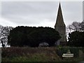
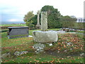
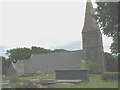
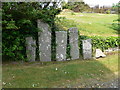
Early mediaeval cross shaft and tombstones in St Caffo's Churchyard, Llangaffo.
You may be viewing yesterday's version of this page. To see the most up to date information please register for a free account.
 (PID:251177)")
 (PID:250718)")
 (PID:33336)")
 (PID:33334)")
Do not use the above information on other web sites or publications without permission of the contributor.
Nearby Images from Geograph Britain and Ireland:
©2006(licence)
©2007(licence)
©2008(licence)
©2010(licence)
©2010(licence)
The above images may not be of the site on this page, they are loaded from Geograph.
Please Submit an Image of this site or go out and take one for us!
Click here to see more info for this site
Nearby sites
Key: Red: member's photo, Blue: 3rd party photo, Yellow: other image, Green: no photo - please go there and take one, Grey: site destroyed
Download sites to:
KML (Google Earth)
GPX (GPS waypoints)
CSV (Garmin/Navman)
CSV (Excel)
To unlock full downloads you need to sign up as a Contributory Member. Otherwise downloads are limited to 50 sites.
Turn off the page maps and other distractions
Nearby sites listing. In the following links * = Image available
1.3km SSE 150° Maesoglan 1* Standing Stone (Menhir) (SH452674)
1.4km SSE 148° Maesoglan 2* Standing Stone (Menhir) (SH453673)
1.4km SE 145° Maesoglan 3* Standing Stone (Menhir) (SH454673)
1.7km E 100° Bodowyr* Passage Grave (SH46276816)
2.3km SE 132° Bryn Gwyn Stones* Stone Circle (SH4623566927)
2.4km SE 125° Castell Bryn-Gwyn* Henge (SH4652867061)
2.5km ESE 117° Tre'r Dryw Bach W Stone Circle (SH468673)
2.6km ESE 102° Pont Sarn Las Ancient Village or Settlement (SH471679)
2.9km ESE 109° Caer Leb* Ancient Village or Settlement (SH47286747)
2.9km ESE 101° Ty Mawr 2* Standing Stone (Menhir) (SH4743667830)
3.1km ESE 101° Ty Mawr 1 (Trefwri)* Standing Stone (Menhir) (SH4761567794)
3.8km ESE 115° Perthiduon* Chambered Tomb (SH4798066758)
3.8km W 280° Malltraeth* Standing Stone (Menhir) (SH4085569306)
4.0km NNW 328° Hen Blas* Burial Chamber or Dolmen (SH42577197)
4.4km ESE 108° Brynsiencyn* Round Barrow(s) (SH488670)
5.1km ESE 106° Maen Morddwyd Early Christian Sculptured Stone (SH495669)
5.2km SW 222° Crochan Llanddwyn* Holy Well or Sacred Spring (SH40986478)
5.6km N 8° Lledwigan* Standing Stone (Menhir) (SH456740)
5.7km NNW 334° St Ceinwen Holy Well* Holy Well or Sacred Spring (SH423737)
6.0km ENE 70° Tyddyn-bach* Standing Stone (Menhir) (SH5031770341)
6.1km SE 141° Modern Stone Circle (Caernarfon)* Modern Stone Circle etc (SH4835463629)
6.2km SE 141° Modern Standing Stones (Caernarfon)* Modern Stone Circle etc (SH4833363592)
6.2km ENE 73° Bryn Celli Ddu Standing Stone* Standing Stone (Menhir) (SH50637010)
6.2km ENE 72° Bryn Celli Ddu Gorsedd* Rock Art (SH50627024)
6.3km W 275° St Cadwaladr (Llangadwaladr)* Early Christian Sculptured Stone (SH38376927)
View more nearby sites and additional images


 We would like to know more about this location. Please feel free to add a brief description and any relevant information in your own language.
 Wir möchten mehr über diese Stätte erfahren. Bitte zögern Sie nicht, eine kurze Beschreibung und relevante Informationen in Deutsch hinzuzufügen.
 Nous aimerions en savoir encore un peu sur les lieux. S'il vous plaît n'hesitez pas à ajouter une courte description et tous les renseignements pertinents dans votre propre langue.
 Quisieramos informarnos un poco más de las lugares. No dude en añadir una breve descripción y otros datos relevantes en su propio idioma.