


<< Our Photo Pages >> Canyon de Chelly - Mummy Cave - Ancient Village or Settlement in United States in The Southwest
Submitted by bat400 on Thursday, 30 August 2007 Page Views: 12657
Multi-periodSite Name: Canyon de Chelly - Mummy Cave Alternative Name: House Under the RockCountry: United States Region: The Southwest Type: Ancient Village or Settlement
Nearest Town: Chinle, Arizona
Latitude: 36.232500N Longitude: 109.3569W
Condition:
| 5 | Perfect |
| 4 | Almost Perfect |
| 3 | Reasonable but with some damage |
| 2 | Ruined but still recognisable as an ancient site |
| 1 | Pretty much destroyed, possibly visible as crop marks |
| 0 | No data. |
| -1 | Completely destroyed |
| 5 | Superb |
| 4 | Good |
| 3 | Ordinary |
| 2 | Not Good |
| 1 | Awful |
| 0 | No data. |
| 5 | Can be driven to, probably with disabled access |
| 4 | Short walk on a footpath |
| 3 | Requiring a bit more of a walk |
| 2 | A long walk |
| 1 | In the middle of nowhere, a nightmare to find |
| 0 | No data. |
| 5 | co-ordinates taken by GPS or official recorded co-ordinates |
| 4 | co-ordinates scaled from a detailed map |
| 3 | co-ordinates scaled from a bad map |
| 2 | co-ordinates of the nearest village |
| 1 | co-ordinates of the nearest town |
| 0 | no data |
Internal Links:
External Links:
I have visited· I would like to visit
DrewParsons would like to visit
jeffrep visited on 5th Oct 2012 - their rating: Cond: 2 Amb: 5 Access: 2
bat400 saw from a distance on 1st Jun 2004 - their rating: Cond: 3 Amb: 5 Access: 2 I saw the ruin from an overlook to the west. You may only approach the ruins with a Navajo guide. There is no access directly into the ruins themselves.
Average ratings for this site from all visit loggers: Condition: 2.5 Ambience: 5 Access: 2
")
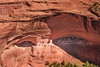
Mummy Cave is one of the canyon sites occupied for the longest continuous period - 300 to 1300AD - with cultures and finds from Basketmaker to the Ancestral Puebloans who built the ruins seen here.
Named from two yucca wrapped preserved bodies found in the alcove in the 1880's. The timbers for the top of the three storey tower in the left of the picture were cut in 1284AD. This tower was in danger of collapsing in the 1930's and was stabilized. [From Native Roads, Fran Kosik, 1996.] This famous ruin of a village complex can be viewed from a canyon rim overlook or on a guided tour.
Note: Ancient "chaws" and preserved textiles yield DNA from southwestern people who used Mummy Cave. What can be discovered from saved "trash."
You may be viewing yesterday's version of this page. To see the most up to date information please register for a free account.
")
")
Do not use the above information on other web sites or publications without permission of the contributor.
Nearby Images from Flickr
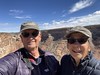

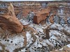
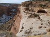

The above images may not be of the site on this page, but were taken nearby. They are loaded from Flickr so please click on them for image credits.
Click here to see more info for this site
Nearby sites
Click here to view sites on an interactive map of the areaKey: Red: member's photo, Blue: 3rd party photo, Yellow: other image, Green: no photo - please go there and take one, Grey: site destroyed
Download sites to:
KML (Google Earth)
GPX (GPS waypoints)
CSV (Garmin/Navman)
CSV (Excel)
To unlock full downloads you need to sign up as a Contributory Member. Otherwise downloads are limited to 50 sites.
Turn off the page maps and other distractions
Nearby sites listing. In the following links * = Image available
11.5km SW 223° Canyon de Chelly - Antelope House Ruins* Ancient Village or Settlement
14.1km SSW 209° Canyon de Chelly - Sliding House* Ancient Village or Settlement
15.0km SW 223° Canyon de Chelly - White House* Ancient Village or Settlement
112.2km ESE 103° Kin Bineola* Ancient Village or Settlement
112.5km NW 320° Monument Valley - Ear of the Wind Handprint Pictographs* Rock Art
112.5km NW 320° Monument Valley - Sun's Eye Arch Petroglyphs* Rock Art
112.5km NW 320° Monument Valley - Water Birth Cliff Petroglyphs* Rock Art
112.5km NW 320° Monument Valley* Ancient Village or Settlement
113.5km NNW 337° Mexican Hat* Natural Stone / Erratic / Other Natural Feature
114.0km NNW 345° Comb Wash Ruins Ancient Village or Settlement
114.7km NNW 346° Kachina Petroglyph Panel Rock Art
116.7km WNW 296° Navajo Nat. Mon. - Betatakin* Ancient Village or Settlement
116.8km NNW 349° Sand Island petroglyph Panel* Rock Art
117.4km WNW 300° Navajo Nat. Mon. - Keet Seel Ancient Village or Settlement
117.5km E 101° Chaco Culture NHP - Kin Klizhin* Ancient Village or Settlement
118.7km N 351° Bluff Great House* Ancient Village or Settlement
118.7km NNW 348° Wolfman Panel Petroglyphs Rock Art
119.6km N 7° Hovenweep - Cajon House* Ancient Village or Settlement
122.7km E 97° Chaco Culture NHP - Peñasco Blanco* Ancient Village or Settlement
122.9km E 97° Chaco Culture NHP - Supernova pictograph* Rock Art
124.0km E 98° Chaco Culture NHP - Penasco Blanco Trail Petroglyphs* Rock Art
124.8km WSW 257° Taawaki Rock Art
125.9km E 98° Chaco Culture NHP - Kin Kletso* Ancient Village or Settlement
126.4km E 98° Chaco Culture NHP - Pueblo del Arroyo* Ancient Village or Settlement
126.7km E 98° Chaco Culture NHP - Pueblo Bonito* Ancient Village or Settlement
View more nearby sites and additional images


 We would like to know more about this location. Please feel free to add a brief description and any relevant information in your own language.
 Wir möchten mehr über diese Stätte erfahren. Bitte zögern Sie nicht, eine kurze Beschreibung und relevante Informationen in Deutsch hinzuzufügen.
 Nous aimerions en savoir encore un peu sur les lieux. S'il vous plaît n'hesitez pas à ajouter une courte description et tous les renseignements pertinents dans votre propre langue.
 Quisieramos informarnos un poco más de las lugares. No dude en añadir una breve descripción y otros datos relevantes en su propio idioma.