


<< Our Photo Pages >> Hall of Gorn - Round Barrow(s) in Scotland in Orkney
Submitted by howar on Tuesday, 02 May 2006 Page Views: 4133
Neolithic and Bronze AgeSite Name: Hall of Gorn Alternative Name: Gorn, Hall of GormCountry: Scotland County: Orkney Type: Round Barrow(s)
Nearest Town: Kirkwall Nearest Village: St. Mary's
Map Ref: HY484026
Latitude: 58.907588N Longitude: 2.897459W
Condition:
| 5 | Perfect |
| 4 | Almost Perfect |
| 3 | Reasonable but with some damage |
| 2 | Ruined but still recognisable as an ancient site |
| 1 | Pretty much destroyed, possibly visible as crop marks |
| 0 | No data. |
| -1 | Completely destroyed |
| 5 | Superb |
| 4 | Good |
| 3 | Ordinary |
| 2 | Not Good |
| 1 | Awful |
| 0 | No data. |
| 5 | Can be driven to, probably with disabled access |
| 4 | Short walk on a footpath |
| 3 | Requiring a bit more of a walk |
| 2 | A long walk |
| 1 | In the middle of nowhere, a nightmare to find |
| 0 | No data. |
| 5 | co-ordinates taken by GPS or official recorded co-ordinates |
| 4 | co-ordinates scaled from a detailed map |
| 3 | co-ordinates scaled from a bad map |
| 2 | co-ordinates of the nearest village |
| 1 | co-ordinates of the nearest town |
| 0 | no data |
Internal Links:
External Links:
")
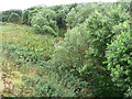
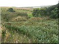
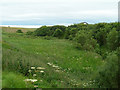
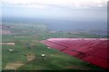
RCAHMS NMRS record no. HY40SE 2 consists of three barrows. The main one, at HY48370261, is a black earth and clay mound about 40x50' by 5'6" from which came a long cist. A couple of decades later some kind of grave was found in one of the others. Their semi-circular remains at HY48400259 & HY48390257, about 8m across and roughly a metre high, are completely turf-covered.
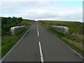
Take the A961 for the South Isles past the Hunclett side road until the sign for Toab when you take B road. Where the road starts downhill the 1:25,000 has a MS symbol on the right and the Hall of Gorn is the unnamed group of buildings before that on the crest of the hill. The most direct route is the field boundary along its RH side. Though you can choose to clamber over the gate to the field you cannot with the field above the last building as the lower bars are only footholds from the outside. The mound, with what is left of its reduced siblings, is in this walled field. It seems to me that the main mound is little dissimilar to Laughton's Knowe in the open field, having a similar outline - a curved shield with a broad low ombos almost like a platform - though less well defined (it may only be apparent in some directions). There is now no sign of blackened earth, so apart from there being bigger chunks of bare soil on Laughton's Knowe the composition looks broadly similar in being mostly turf-covered with earthfast boulders at various places in no obvious pattern. As with the knowe you naturally expect to gauge the depth of stones protruding through the turf by a slight pull, but when I tried this several of these, even the boulders, didn't budge at all. Is these being earthfast evidence for structures within (or having been there once leastways). When I visited I had forgotten about other mounds but did notice what I then took to be curvilinear banks between the main mound and the farmstead. Nearer the farm buildings still is a modern water-point on the slope of the hill - the 1882 map shows no well here but that is not 100% accurate always. It is above a large slab covering something, presumably a well but my leg pain stopped me lifting it up far enough to check. There are other stones and smaller slabs about this one, and I do wonder if they came from the grave site.
You may be viewing yesterday's version of this page. To see the most up to date information please register for a free account.
")
")
")
Do not use the above information on other web sites or publications without permission of the contributor.
Nearby Images from Geograph Britain and Ireland:
©2006(licence)
©2006(licence)
©2006(licence)
©2009(licence)
©2009(licence)
The above images may not be of the site on this page, they are loaded from Geograph.
Please Submit an Image of this site or go out and take one for us!
Click here to see more info for this site
Nearby sites
Key: Red: member's photo, Blue: 3rd party photo, Yellow: other image, Green: no photo - please go there and take one, Grey: site destroyed
Download sites to:
KML (Google Earth)
GPX (GPS waypoints)
CSV (Garmin/Navman)
CSV (Excel)
To unlock full downloads you need to sign up as a Contributory Member. Otherwise downloads are limited to 50 sites.
Turn off the page maps and other distractions
Nearby sites listing. In the following links * = Image available
141m W 261° Laughton's Knowe* Round Barrow(s) (HY48260258)
931m ESE 105° Crearhowe* Artificial Mound (HY49300235)
1.0km SE 138° Mass Howe* Misc. Earthwork (HY49090181)
1.3km WNW 302° Holm Chambered Tomb* Chambered Tomb (HY473033)
1.4km SE 130° Tower of Clett* Artificial Mound (HY4949701654)
1.8km SW 229° St Mary's Broch* Broch or Nuraghe (HY470014)
1.9km WNW 294° Gutterpool* Misc. Earthwork (HY467034)
2.1km S 179° Lamb Holm* Ancient Village or Settlement (HY484005)
3.3km SE 127° St. Nicholas Church* Ancient Village or Settlement (HY510006)
3.4km NW 310° Mark Stone of Gaitnip* Standing Stone (Menhir) (HY458048)
3.7km NW 318° The Five Hillocks* Barrow Cemetery (HY45980536)
3.8km SE 127° Castle Howe (Orkney)* Ancient Village or Settlement (HY514003)
3.8km S 172° Northfield Broch* Broch or Nuraghe (ND489988)
3.9km N 349° Heathery Howes* Round Barrow(s) (HY477064)
3.9km NNE 28° Brymer* Round Barrow(s) (HY503060)
4.0km NE 34° Burn of Langskaill* Ancient Village or Settlement (HY507059)
4.1km NE 35° Round Howe* Broch or Nuraghe (HY50780591)
4.2km NE 36° Long Howe* Long Barrow (HY509060)
4.3km NE 37° Mine Howe* Chambered Cairn (HY5106406023)
4.4km N 8° Craw Howe* Cairn (HY491069)
4.4km N 358° Staneloof* Cairn (HY48330698)
4.4km NE 35° Stem Howe* Round Barrow(s) (HY510062)
4.4km NW 313° Burn of Deepdale* Ancient Village or Settlement (HY452057)
4.5km NE 38° Longhowe Cairn (HY512061)
4.6km ENE 70° Campston (Toab)* Broch or Nuraghe (HY528041)
View more nearby sites and additional images


 We would like to know more about this location. Please feel free to add a brief description and any relevant information in your own language.
 Wir möchten mehr über diese Stätte erfahren. Bitte zögern Sie nicht, eine kurze Beschreibung und relevante Informationen in Deutsch hinzuzufügen.
 Nous aimerions en savoir encore un peu sur les lieux. S'il vous plaît n'hesitez pas à ajouter une courte description et tous les renseignements pertinents dans votre propre langue.
 Quisieramos informarnos un poco más de las lugares. No dude en añadir una breve descripción y otros datos relevantes en su propio idioma.