

<< Our Photo Pages >> Caucanas Dolmen - Burial Chamber or Dolmen in France in Languedoc:Gard (30)
Submitted by ocdolmen on Wednesday, 29 August 2018 Page Views: 3558
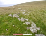
Neolithic and Bronze AgeSite Name: Caucanas DolmenCountry: France Département: Languedoc:Gard (30) Type: Burial Chamber or Dolmen
Nearest Town: Rogues Nearest Village: Caucanas hamlet
Latitude: 43.908010N Longitude: 3.596460E
Condition:
| 5 | Perfect |
| 4 | Almost Perfect |
| 3 | Reasonable but with some damage |
| 2 | Ruined but still recognisable as an ancient site |
| 1 | Pretty much destroyed, possibly visible as crop marks |
| 0 | No data. |
| -1 | Completely destroyed |
| 5 | Superb |
| 4 | Good |
| 3 | Ordinary |
| 2 | Not Good |
| 1 | Awful |
| 0 | No data. |
| 5 | Can be driven to, probably with disabled access |
| 4 | Short walk on a footpath |
| 3 | Requiring a bit more of a walk |
| 2 | A long walk |
| 1 | In the middle of nowhere, a nightmare to find |
| 0 | No data. |
| 5 | co-ordinates taken by GPS or official recorded co-ordinates |
| 4 | co-ordinates scaled from a detailed map |
| 3 | co-ordinates scaled from a bad map |
| 2 | co-ordinates of the nearest village |
| 1 | co-ordinates of the nearest town |
| 0 | no data |
Internal Links:
External Links:
I have visited· I would like to visit
SolarMegalith would like to visit
regina has visited here
")
From LaDragonne. "En fait, les photos ne montrent que la première partie du monument et la première dalle de couverture. La chambre mesure 4m80 de l'entrée jusqu'au socle enfoui de la dalle de chevet, volontairement brisée. Le couloir est étroit (60 à 80cm)
Les constructeurs se sont servi des bandes de calcaire affleurant pour servir d'orthostate gauche. Les autres parties sont d'un calcaire plus jaune, amené sur place.
D'autres énormes pierres calcaires ont été amenées à 50m, en extrémité du promontoire sur lequel se trouve le dolmen".
You may be viewing yesterday's version of this page. To see the most up to date information please register for a free account.
")
")
")
")
")
")
")
")
")
Do not use the above information on other web sites or publications without permission of the contributor.
Click here to see more info for this site
Nearby sites
Click here to view sites on an interactive map of the areaKey: Red: member's photo, Blue: 3rd party photo, Yellow: other image, Green: no photo - please go there and take one, Grey: site destroyed
Download sites to:
KML (Google Earth)
GPX (GPS waypoints)
CSV (Garmin/Navman)
CSV (Excel)
To unlock full downloads you need to sign up as a Contributory Member. Otherwise downloads are limited to 50 sites.
Turn off the page maps and other distractions
Nearby sites listing. In the following links * = Image available
597m WNW 300° Dolmen de la Tude* Burial Chamber or Dolmen
1.8km W 277° Menhirs de Campouillas* Standing Stone (Menhir)
2.1km WNW 286° Flouirac Dolmen* Burial Chamber or Dolmen
2.2km SW 230° Ciste de Rogues* Cist
2.5km SW 218° Oppidum de la Blacarède* Ancient Village or Settlement
2.6km WNW 290° Dolmen de la Caucalière* Burial Chamber or Dolmen
2.6km WNW 289° Caucalière Menhir* Standing Stone (Menhir)
3.0km WSW 240° Lacam de Rogues 2* Stone Circle
3.1km SW 233° Lacam Tumulus 2* Round Barrow(s)
3.1km SW 232° Ciste de Lacam* Burial Chamber or Dolmen
3.2km SW 232° Lacam de Rogues 1* Stone Circle
3.2km SW 231° Ciste de Lacalm 2* Cist
3.2km SW 234° Menhir Camp de Bouissière* Standing Stone (Menhir)
3.2km WSW 239° Lacam menhir* Standing Stone (Menhir)
3.4km W 279° Dolmen de Barral* Burial Chamber or Dolmen
3.5km SW 227° Trivalle menhir* Standing Stone (Menhir)
3.6km SW 235° Menhir de Gagnat* Standing Stone (Menhir)
3.7km E 80° Grotte d'Anjeau* Cave or Rock Shelter
4.3km SW 232° Gouarens Tumulus* Round Barrow(s)
4.5km NNE 25° Pommiers menhir* Standing Stone (Menhir)
4.5km WNW 288° Regos Dolmen* Burial Chamber or Dolmen
4.7km W 274° Dolmen du Chateau d'Assas* Burial Chamber or Dolmen
4.8km WSW 251° Dolmen Borie d'Arre 3* Burial Chamber or Dolmen
4.8km WSW 251° Dolmen de la Borie d'Arre 2* Burial Chamber or Dolmen
5.0km SW 229° Dolmen du Sotch de Gardie* Burial Chamber or Dolmen
View more nearby sites and additional images


 We would like to know more about this location. Please feel free to add a brief description and any relevant information in your own language.
 Wir möchten mehr über diese Stätte erfahren. Bitte zögern Sie nicht, eine kurze Beschreibung und relevante Informationen in Deutsch hinzuzufügen.
 Nous aimerions en savoir encore un peu sur les lieux. S'il vous plaît n'hesitez pas à ajouter une courte description et tous les renseignements pertinents dans votre propre langue.
 Quisieramos informarnos un poco más de las lugares. No dude en añadir una breve descripción y otros datos relevantes en su propio idioma.