

<< Our Photo Pages >> Callanish 17 - Stone Circle in Scotland in Isle of Lewis
Submitted by Anonymous on Thursday, 15 February 2001 Page Views: 7372
Neolithic and Bronze AgeSite Name: Callanish 17 Alternative Name: Druim na h' Aon Chloich, Callanish XVIICountry: Scotland County: Isle of Lewis Type: Stone Circle
Nearest Town: Stornoway Nearest Village: Callanish
Map Ref: NB237320 Landranger Map Number: 8
Latitude: 58.189977N Longitude: 6.703214W
Condition:
| 5 | Perfect |
| 4 | Almost Perfect |
| 3 | Reasonable but with some damage |
| 2 | Ruined but still recognisable as an ancient site |
| 1 | Pretty much destroyed, possibly visible as crop marks |
| 0 | No data. |
| -1 | Completely destroyed |
| 5 | Superb |
| 4 | Good |
| 3 | Ordinary |
| 2 | Not Good |
| 1 | Awful |
| 0 | No data. |
| 5 | Can be driven to, probably with disabled access |
| 4 | Short walk on a footpath |
| 3 | Requiring a bit more of a walk |
| 2 | A long walk |
| 1 | In the middle of nowhere, a nightmare to find |
| 0 | No data. |
| 5 | co-ordinates taken by GPS or official recorded co-ordinates |
| 4 | co-ordinates scaled from a detailed map |
| 3 | co-ordinates scaled from a bad map |
| 2 | co-ordinates of the nearest village |
| 1 | co-ordinates of the nearest town |
| 0 | no data |
Internal Links:
External Links:
I have visited· I would like to visit
tom_bullock has visited here
")
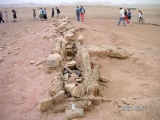
"The Stones around Callanish" (ISBN:0-9505998-9-1 published in 1984) tells 'The stone is under the power cables and marked by several surveyors' pegs', but now almost no clue which indicate its position remains. It lies in a hollow in a meadow, might be much harder target than Callanish 13. The combination of a flat stone with a slit and another long stone with a sharp point might have some sexual suggestion about fertility like Cern Giant hill figure.
You may be viewing yesterday's version of this page. To see the most up to date information please register for a free account.
")
")
Do not use the above information on other web sites or publications without permission of the contributor.
Nearby Images from Geograph Britain and Ireland:
©2023(licence)
©2023(licence)
©2023(licence)
©2007(licence)
©2006(licence)
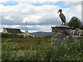
The above images may not be of the site on this page, they are loaded from Geograph.
Please Submit an Image of this site or go out and take one for us!
Click here to see more info for this site
Nearby sites
Key: Red: member's photo, Blue: 3rd party photo, Yellow: other image, Green: no photo - please go there and take one, Grey: site destroyed
Download sites to:
KML (Google Earth)
GPX (GPS waypoints)
CSV (Garmin/Navman)
CSV (Excel)
To unlock full downloads you need to sign up as a Contributory Member. Otherwise downloads are limited to 50 sites.
![]()
Turn off the page maps and other distractions
Nearby sites listing. In the following links * = Image available
1.0km W 270° Cnoc Fillibhir Mhor* Stone Row / Alignment (NB22683207)
1.3km NW 311° Callanish 14* Standing Stone (Menhir) (NB228329)
1.4km WNW 297° Callanish 3* Stone Circle (NB2251532710)
1.6km WNW 284° Loch Roag Timber Circle (NB222325)
1.6km WNW 288° Callanish 2* Stone Circle (NB2221432614)
1.7km SSW 200° Callanish 4* Stone Circle (NB2298830412)
1.8km NNW 332° Callanish 10* Stone Circle (NB22973362)
1.9km SSW 192° Callanish 7* Ancient Mine, Quarry or other Industry (NB232302)
1.9km SSE 146° Callanish 6* Standing Stones (NB24653034)
2.1km S 183° Callanish 5* Stone Row / Alignment (NB23432990)
2.2km WNW 296° Callanish 19* Stone Circle (NB218331)
2.3km S 186° Callanish 9* Standing Stones (NB233297)
2.6km WNW 289° Callanish* Stone Circle (NB2129833013)
2.6km WNW 289° Callanish I* Stone Circle (NB2128633009)
2.9km SSE 162° Callanish 18* Standing Stone (Menhir) (NB24402923)
3.0km WNW 303° Callanish 16* Standing Stone (Menhir) (NB213338)
3.0km NW 310° Callanish 13* Standing Stones (NB215341)
3.3km NW 321° Olcote Kerbed Cairn* Cairn (NB2179634733)
3.6km NW 320° Callanish 12* Standing Stone (Menhir) (NB2155634967)
4.0km NNW 334° Callanish 11* Standing Stone (Menhir) (NB22233569)
4.3km NW 319° Cnoc a Phrionnsa* Chambered Cairn (NB211355)
6.5km WNW 289° Callanish 15* Standing Stone (Menhir) (NB177345)
7.3km WNW 285° Dun Barraglom Broch or Nuraghe (NB16773435)
7.3km WNW 284° Barraglom Cup-Marked Rock Rock Art (NB167343)
7.4km WNW 282° Callanish 8A* Standing Stone (Menhir) (NB165340)
View more nearby sites and additional images


 We would like to know more about this location. Please feel free to add a brief description and any relevant information in your own language.
 Wir möchten mehr über diese Stätte erfahren. Bitte zögern Sie nicht, eine kurze Beschreibung und relevante Informationen in Deutsch hinzuzufügen.
 Nous aimerions en savoir encore un peu sur les lieux. S'il vous plaît n'hesitez pas à ajouter une courte description et tous les renseignements pertinents dans votre propre langue.
 Quisieramos informarnos un poco más de las lugares. No dude en añadir una breve descripción y otros datos relevantes en su propio idioma.