 with our Megalithic Portal iPhone app")

<< Our Photo Pages >> Allée couverte de la Chapelle - Passage Grave in France in Ile-de-France:Val-d'Oise (95)
Submitted by binardino on Thursday, 10 February 2005 Page Views: 4575
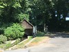
Neolithic and Bronze AgeSite Name: Allée couverte de la Chapelle Alternative Name: LabbevilleCountry: France Département: Ile-de-France:Val-d'Oise (95) Type: Passage Grave
Nearest Town: L'Isle-Adam Nearest Village: Labbeville
Latitude: 49.141500N Longitude: 2.119800E
Condition:
| 5 | Perfect |
| 4 | Almost Perfect |
| 3 | Reasonable but with some damage |
| 2 | Ruined but still recognisable as an ancient site |
| 1 | Pretty much destroyed, possibly visible as crop marks |
| 0 | No data. |
| -1 | Completely destroyed |
| 5 | Superb |
| 4 | Good |
| 3 | Ordinary |
| 2 | Not Good |
| 1 | Awful |
| 0 | No data. |
| 5 | Can be driven to, probably with disabled access |
| 4 | Short walk on a footpath |
| 3 | Requiring a bit more of a walk |
| 2 | A long walk |
| 1 | In the middle of nowhere, a nightmare to find |
| 0 | No data. |
| 5 | co-ordinates taken by GPS or official recorded co-ordinates |
| 4 | co-ordinates scaled from a detailed map |
| 3 | co-ordinates scaled from a bad map |
| 2 | co-ordinates of the nearest village |
| 1 | co-ordinates of the nearest town |
| 0 | no data |
Internal Links:
External Links:
")
Labbeville passage grave is smaller than cote du libéra around 10-meters long and 1.5 large.
We can see too a menhir made with the same stone as the passage grave, located 5 meters before passage grave entrance.
IMPORTANT NOTE :- Site believed to be near this position.
You may be viewing yesterday's version of this page. To see the most up to date information please register for a free account.
Do not use the above information on other web sites or publications without permission of the contributor.
Nearby Images from Flickr
The above images may not be of the site on this page, but were taken nearby. They are loaded from Flickr so please click on them for image credits.
Click here to see more info for this site
Nearby sites
Click here to view sites on an interactive map of the areaKey: Red: member's photo, Blue: 3rd party photo, Yellow: other image, Green: no photo - please go there and take one, Grey: site destroyed
Download sites to:
KML (Google Earth)
GPX (GPS waypoints)
CSV (Garmin/Navman)
CSV (Excel)
To unlock full downloads you need to sign up as a Contributory Member. Otherwise downloads are limited to 50 sites.
Turn off the page maps and other distractions
Nearby sites listing. In the following links * = Image available
2.3km N 0° Vigne des Grès Menhir* Standing Stone (Menhir)
2.3km N 360° Côte du Libéria* Passage Grave
4.5km SSE 168° Herouville Chateau Stones Ancient Village or Settlement
5.3km E 82° Polissoir de la Forêt du Lay Polissoir
5.7km E 97° Hypogée le Trou à Mort* Chambered Tomb
6.8km N 0° Amblainville Polissoir* Standing Stone (Menhir)
7.1km ESE 117° Le Temple Passage Grave
7.7km S 189° Menhir de la Haute Borne (Ennery)* Standing Stone (Menhir)
9.1km E 92° Basses Coutures* Standing Stones
9.2km SE 137° Dolmen le Mériel Passage Grave
9.3km SE 137° L'Abbaye du Val Passage Grave
9.8km NW 314° Pierre aux Coqs Standing Stone (Menhir)
9.9km NW 317° Pierre Fritte de Neuville-Bosc* Standing Stone (Menhir)
10.2km S 188° Dampont Allée couverte* Passage Grave
11.0km ESE 109° La Pierre Plate (Presles)* Passage Grave
11.1km E 83° Le Pré du Fresnoy Passage Grave
11.8km ESE 105° Coffre mégalithique du château D'eau de Bellevue* Chambered Tomb
12.3km SSW 206° Pierre du Fouret* Standing Stone (Menhir)
12.6km ESE 109° Le Blanc Val Allée couverte* Passage Grave
12.9km ESE 117° La Justice Passage Grave
12.9km WNW 294° Pierre Frite de Lavilletertre* Standing Stone (Menhir)
14.0km SSW 208° Cimetière des Anglais Allée couverte* Passage Grave
14.7km ESE 106° Pierre Turquaise* Passage Grave
14.7km SSW 205° Menhir la Grande Pierre de Jouy* Standing Stone (Menhir)
14.8km ESE 106° Saint-Martin-du-Tertre Menhir* Standing Stone (Menhir)
View more nearby sites and additional images


 We would like to know more about this location. Please feel free to add a brief description and any relevant information in your own language.
 Wir möchten mehr über diese Stätte erfahren. Bitte zögern Sie nicht, eine kurze Beschreibung und relevante Informationen in Deutsch hinzuzufügen.
 Nous aimerions en savoir encore un peu sur les lieux. S'il vous plaît n'hesitez pas à ajouter une courte description et tous les renseignements pertinents dans votre propre langue.
 Quisieramos informarnos un poco más de las lugares. No dude en añadir una breve descripción y otros datos relevantes en su propio idioma.