


<< Our Photo Pages >> Cove Hole - Cave or Rock Shelter in England in Yorkshire (North)
Submitted by cavegirl on Saturday, 04 September 2004 Page Views: 12023
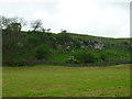
Natural PlacesSite Name: Cove Hole Alternative Name: Fairy Cave, Tom Lee's CaveCountry: England County: Yorkshire (North) Type: Cave or Rock Shelter
Nearest Town: Grassington
Map Ref: SD99896499
Latitude: 54.080830N Longitude: 2.003174W
Condition:
| 5 | Perfect |
| 4 | Almost Perfect |
| 3 | Reasonable but with some damage |
| 2 | Ruined but still recognisable as an ancient site |
| 1 | Pretty much destroyed, possibly visible as crop marks |
| 0 | No data. |
| -1 | Completely destroyed |
| 5 | Superb |
| 4 | Good |
| 3 | Ordinary |
| 2 | Not Good |
| 1 | Awful |
| 0 | No data. |
| 5 | Can be driven to, probably with disabled access |
| 4 | Short walk on a footpath |
| 3 | Requiring a bit more of a walk |
| 2 | A long walk |
| 1 | In the middle of nowhere, a nightmare to find |
| 0 | No data. |
| 5 | co-ordinates taken by GPS or official recorded co-ordinates |
| 4 | co-ordinates scaled from a detailed map |
| 3 | co-ordinates scaled from a bad map |
| 2 | co-ordinates of the nearest village |
| 1 | co-ordinates of the nearest town |
| 0 | no data |
Internal Links:
External Links:
I have visited· I would like to visit
AmyBlahBlahBlah would like to visit
")
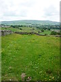
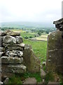
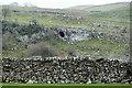
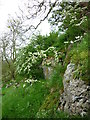
A walk through cave in the scar with good views out over Grassington and a 'back door' out onto the pasture.
The cave was excavated in the 1930s and the remains of one person, possible Iron Age in date, were found but it's not known who did the digging, nor where the remains now are.
You may be viewing yesterday's version of this page. To see the most up to date information please register for a free account.
Do not use the above information on other web sites or publications without permission of the contributor.
Nearby Images from Geograph Britain and Ireland:
©2014(licence)
©2013(licence)
©2019(licence)
©2014(licence)
©2014(licence)
The above images may not be of the site on this page, they are loaded from Geograph.
Please Submit an Image of this site or go out and take one for us!
Click here to see more info for this site
Nearby sites
Key: Red: member's photo, Blue: 3rd party photo, Yellow: other image, Green: no photo - please go there and take one, Grey: site destroyed
Download sites to:
KML (Google Earth)
GPX (GPS waypoints)
CSV (Garmin/Navman)
CSV (Excel)
To unlock full downloads you need to sign up as a Contributory Member. Otherwise downloads are limited to 50 sites.
Turn off the page maps and other distractions
Nearby sites listing. In the following links * = Image available
470m NE 55° Grassington Settlement Ancient Village or Settlement (SE0027765259)
1.4km NNW 343° Lea Green cairn Cairn (SD995663)
1.4km ENE 69° Yarnbury Settlement (Grassington) Ancient Village or Settlement (SE012655)
1.6km ENE 74° Yarnbury Henge* Henge (SE0140665415)
1.8km WSW 247° Little Wood* Ancient Village or Settlement (SD98266429)
1.9km SSE 160° Linton Churchyard Cross* Ancient Cross (SE0053963220)
1.9km SSE 164° The Linton Stones* Natural Stone / Erratic / Other Natural Feature (SE0042763177)
2.0km W 270° Brazen Gate* Round Cairn (SD9785964995)
2.4km W 278° Chapel House Wood* Ancient Village or Settlement (SD9750165316)
3.0km NNE 28° Green Hill Pasture Stone Circle* Stone Circle (SE013676)
3.0km ESE 103° Mossy Moor Reservoir* Ring Cairn (SE02866432)
3.1km ENE 58° Grassington A* Stone Circle (SE025666)
3.1km ENE 57° Grassington B* Stone Circle (SE025667)
3.1km ESE 107° Dumpit Hill Enclosure Ancient Village or Settlement (SE0288464062)
3.2km ESE 108° Dumpit Hill* Stone Circle (SE02996399)
3.3km ESE 106° Dumpit Hill B (Hebden) Stone Circle (SE03076406)
3.5km W 264° Heights Cave* Cave or Rock Shelter (SD96446460)
3.5km SSE 165° Ebolton Cave* Cave or Rock Shelter (SE008616)
4.5km W 269° Hammond Close (Threshfield)* Ancient Village or Settlement (SD95386492)
4.6km W 278° Lantern Holes (Bordley)* Ancient Village or Settlement (SD95336566)
4.7km W 273° Hammond Close Stone (Threshfield) Standing Stones (SD9516165209)
4.8km ESE 110° Hartlington Pasture 01* Rock Art (SE04396338)
4.8km SE 137° Burnsall Crosses* Ancient Cross (SE032615)
4.9km ESE 105° Hartlington Pasture 02* Rock Art (SE04676373)
4.9km W 273° Druid's Altar (Yorkshire)* Stone Circle (SD94946527)
View more nearby sites and additional images


 We would like to know more about this location. Please feel free to add a brief description and any relevant information in your own language.
 Wir möchten mehr über diese Stätte erfahren. Bitte zögern Sie nicht, eine kurze Beschreibung und relevante Informationen in Deutsch hinzuzufügen.
 Nous aimerions en savoir encore un peu sur les lieux. S'il vous plaît n'hesitez pas à ajouter une courte description et tous les renseignements pertinents dans votre propre langue.
 Quisieramos informarnos un poco más de las lugares. No dude en añadir una breve descripción y otros datos relevantes en su propio idioma.