


<< Our Photo Pages >> Clouduhall Stone - Standing Stone (Menhir) in Scotland in Orkney
Submitted by howar on Wednesday, 08 September 2004 Page Views: 5044
Neolithic and Bronze AgeSite Name: Clouduhall Stone Alternative Name: Cloddishaugh, Cloddiehaugh, Cloddieha', Stensigar, Kirkie HillCountry: Scotland County: Orkney Type: Standing Stone (Menhir)
Nearest Town: Kirkwall Nearest Village: St. Margaret's Hope
Map Ref: ND43538957
Latitude: 58.789974N Longitude: 2.978677W
Condition:
| 5 | Perfect |
| 4 | Almost Perfect |
| 3 | Reasonable but with some damage |
| 2 | Ruined but still recognisable as an ancient site |
| 1 | Pretty much destroyed, possibly visible as crop marks |
| 0 | No data. |
| -1 | Completely destroyed |
| 5 | Superb |
| 4 | Good |
| 3 | Ordinary |
| 2 | Not Good |
| 1 | Awful |
| 0 | No data. |
| 5 | Can be driven to, probably with disabled access |
| 4 | Short walk on a footpath |
| 3 | Requiring a bit more of a walk |
| 2 | A long walk |
| 1 | In the middle of nowhere, a nightmare to find |
| 0 | No data. |
| 5 | co-ordinates taken by GPS or official recorded co-ordinates |
| 4 | co-ordinates scaled from a detailed map |
| 3 | co-ordinates scaled from a bad map |
| 2 | co-ordinates of the nearest village |
| 1 | co-ordinates of the nearest town |
| 0 | no data |
Internal Links:
External Links:
")
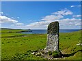
RCAHMS NMRS record no. ND48NW 1. From Clouduhall Cairn go to the left across the field and downhill to the stone, 8'2" high and 4'6" at its widest part.
It appears to sit in a hollow and have an annular ditch in close proximity as shown by the ring of darker green grass. I am minded on of the Comet Stone and 'my' Grieves Cottage site (though the circle is far tighter here). Nearing it I see a large boulder to my right. Hidden amongst the grass I think I make out another such boulder, probably a fraction smaller, just downhill of the stone. At the Clouduhall standing stone itself I cannot see a stone setting. It has a small bulbous bit a little above the summer vegetation, too low for a shoulder and not sticky-out enough for a hip.
You may be viewing yesterday's version of this page. To see the most up to date information please register for a free account.
")
")
")
Do not use the above information on other web sites or publications without permission of the contributor.
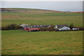
Nearby Images from Geograph Britain and Ireland:
©2022(licence)
©2008(licence)
©2008(licence)
©2018(licence)
©2008(licence)
The above images may not be of the site on this page, they are loaded from Geograph.
Please Submit an Image of this site or go out and take one for us!
Click here to see more info for this site
Nearby sites
Key: Red: member's photo, Blue: 3rd party photo, Yellow: other image, Green: no photo - please go there and take one, Grey: site destroyed
Download sites to:
KML (Google Earth)
GPX (GPS waypoints)
CSV (Garmin/Navman)
CSV (Excel)
To unlock full downloads you need to sign up as a Contributory Member. Otherwise downloads are limited to 50 sites.
Turn off the page maps and other distractions
Nearby sites listing. In the following links * = Image available
41m WNW 283° Clouduhall Cairn* Round Cairn (ND43498958)
682m S 190° Weems Castle Broch or Nuraghe (ND434889)
2.1km WNW 292° Harra Brough* Broch or Nuraghe (ND41579038)
2.9km N 1° Oyce of Quindry* Standing Stone (Menhir) (ND436925)
3.0km E 100° Stews* Standing Stone (Menhir) (ND465890)
3.2km SE 135° The Cairns Windwick Bay* Broch or Nuraghe (ND4578987256)
3.7km ENE 68° Kirkhouse* Round Cairn (ND470909)
3.8km ENE 61° Eastside* Standing Stone (Menhir) (ND469914)
3.9km N 356° The Wart* Chambered Cairn (ND433935)
4.2km ENE 67° Kirk Ness* Round Cairn (ND47389117)
4.2km ENE 66° Kirk Ness Dyke* Ancient Village or Settlement (ND474912)
4.5km NNW 346° Howe of Hoxa* Broch or Nuraghe (ND425940)
4.6km NNW 345° Little Howe of Hoxa* Ancient Village or Settlement (ND4243694026)
4.6km NNW 345° Little Howe of Hoxa* Ancient Village or Settlement (ND42439403)
5.3km S 174° Ladykirk Stone* Rock Art (ND44008428)
6.2km SSE 151° Liddel 2 Burnt Mound Ancient Village or Settlement (ND46498416)
6.2km SE 145° Isbister: Tomb Of The Eagles* Chambered Cairn (ND47048449)
6.2km SSE 151° Isbister: Bronze Age House* Ancient Village or Settlement (ND46468411)
6.3km SSE 146° Duni Geo* Long Barrow (ND46958425)
6.3km SSE 154° Tomb of the Eagles Museum Museum (ND4619783807)
6.6km SSE 159° Banks Chambered Tomb* Chambered Cairn (ND45808339)
7.6km NE 40° Kyelittle* Broch or Nuraghe (ND485953)
8.9km NE 39° St Lawrence's Church* Broch or Nuraghe (ND4917896425)
9.2km W 267° Cantick Head Bowl Barrow Round Barrow(s) (ND34318915)
9.3km W 269° Outer Green Hill Broch Chambered Cairn (ND34258958)
View more nearby sites and additional images


 We would like to know more about this location. Please feel free to add a brief description and any relevant information in your own language.
 Wir möchten mehr über diese Stätte erfahren. Bitte zögern Sie nicht, eine kurze Beschreibung und relevante Informationen in Deutsch hinzuzufügen.
 Nous aimerions en savoir encore un peu sur les lieux. S'il vous plaît n'hesitez pas à ajouter une courte description et tous les renseignements pertinents dans votre propre langue.
 Quisieramos informarnos un poco más de las lugares. No dude en añadir una breve descripción y otros datos relevantes en su propio idioma.