 with our Megalithic Portal iPhone app")


<< Our Photo Pages >> Bagan Archaeological Museum - Museum in Burma (Myanmar)
Submitted by DrewParsons on Saturday, 03 November 2018 Page Views: 1588
MuseumsSite Name: Bagan Archaeological MuseumCountry: Burma (Myanmar)
NOTE: This site is 249.642 km away from the location you searched for.
Type: Museum
Nearest Town: Bagan Nearest Village: Old Bagan
Latitude: 21.167800N Longitude: 94.856070E
Condition:
| 5 | Perfect |
| 4 | Almost Perfect |
| 3 | Reasonable but with some damage |
| 2 | Ruined but still recognisable as an ancient site |
| 1 | Pretty much destroyed, possibly visible as crop marks |
| 0 | No data. |
| -1 | Completely destroyed |
| 5 | Superb |
| 4 | Good |
| 3 | Ordinary |
| 2 | Not Good |
| 1 | Awful |
| 0 | No data. |
| 5 | Can be driven to, probably with disabled access |
| 4 | Short walk on a footpath |
| 3 | Requiring a bit more of a walk |
| 2 | A long walk |
| 1 | In the middle of nowhere, a nightmare to find |
| 0 | No data. |
| 5 | co-ordinates taken by GPS or official recorded co-ordinates |
| 4 | co-ordinates scaled from a detailed map |
| 3 | co-ordinates scaled from a bad map |
| 2 | co-ordinates of the nearest village |
| 1 | co-ordinates of the nearest town |
| 0 | no data |
Internal Links:
External Links:
I have visited· I would like to visit
DrewParsons has visited here
")
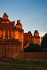
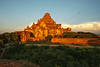
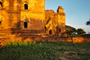
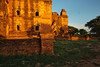
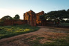
Bagan Archaeological Museum is located in Old Bagan and contains good displays of some of the archaeological items found in this area. In particular it has one of the two Myazedi Inscription columns which are the Rosetta Stone of ancient Burmese languages.
You may be viewing yesterday's version of this page. To see the most up to date information please register for a free account.
")
")
")
Do not use the above information on other web sites or publications without permission of the contributor.
Nearby Images from Flickr
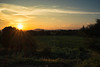
The above images may not be of the site on this page, but were taken nearby. They are loaded from Flickr so please click on them for image credits.
Click here to see more info for this site
Nearby sites
Click here to view sites on an interactive map of the areaKey: Red: member's photo, Blue: 3rd party photo, Yellow: other image, Green: no photo - please go there and take one, Grey: site destroyed
Download sites to:
KML (Google Earth)
GPX (GPS waypoints)
CSV (Garmin/Navman)
CSV (Excel)
To unlock full downloads you need to sign up as a Contributory Member. Otherwise downloads are limited to 50 sites.
Turn off the page maps and other distractions
Nearby sites listing. In the following links * = Image available
657m NE 42° Bagan temple area* Ancient Temple
46.3km SE 128° Popa Taungkalat Monastery* Ancient Temple
140.1km SSE 157° Beikthano-myo Ancient Village or Settlement
504.5km SSE 164° Shwedagon Pagoda* Ancient Temple
523.5km NW 307° Wari-Bateswar Ancient Village or Settlement
561.3km NW 326° Cherrapunji* Standing Stones
571.4km NNW 327° Mawphlang Sacred Forest* Standing Stones
597.2km ESE 119° San Chao Pho Pratu Pha Rock Art
616.7km NNW 339° Mahadeoshal Ancient Village or Settlement
641.2km N 359° Charaideo Maidams Barrow Cemetery
668.8km SE 133° Sukothai* Ancient Village or Settlement
704.2km NW 308° Mahasthangarh Ancient Village or Settlement
771.6km NNW 335° Gom Kora Bhutan Natural Stone / Erratic / Other Natural Feature
825.3km NNW 331° Bumthang cup-marked Stone Rock Art
826.4km NNW 331° Dorje Dolmen Thamshing* Burial Chamber or Dolmen
874.3km ESE 115° Phu Phra Bat Historical Park Rock Art
887.2km NW 323° The National Museum of Bhutan* Museum
891.4km NW 323° Kyichu Lhakhang Ancient Temple
896.5km NW 323° Taktsang Monastery, Bhutan* Ancient Temple
910.9km ESE 101° The Plain of Jars* Ancient Mine, Quarry or other Industry
923.3km W 263° Konarak sun temple* Ancient Temple
929.4km NNW 341° Tibetan Kings´Tombs Artificial Mound
934.6km SE 138° Lopburi Temples* Ancient Temple
942.9km W 265° Rajarani temple* Ancient Temple
943.2km W 265° Parsusrameswar temple* Ancient Temple
View more nearby sites and additional images


 We would like to know more about this location. Please feel free to add a brief description and any relevant information in your own language.
 Wir möchten mehr über diese Stätte erfahren. Bitte zögern Sie nicht, eine kurze Beschreibung und relevante Informationen in Deutsch hinzuzufügen.
 Nous aimerions en savoir encore un peu sur les lieux. S'il vous plaît n'hesitez pas à ajouter une courte description et tous les renseignements pertinents dans votre propre langue.
 Quisieramos informarnos un poco más de las lugares. No dude en añadir una breve descripción y otros datos relevantes en su propio idioma.