 with our Megalithic Portal iPhone app")

<< Our Photo Pages >> Su Tempiesu Villaggio Nuragico - Ancient Village or Settlement in Italy in Sardinia (Sardegna)
Submitted by AlexHunger on Tuesday, 24 October 2006 Page Views: 3830
Multi-periodSite Name: Su Tempiesu Villaggio NuragicoCountry: Italy
NOTE: This site is 3.914 km away from the location you searched for.
Region: Sardinia (Sardegna) Type: Ancient Village or Settlement
Nearest Town: Nuoro Nearest Village: Orune
Latitude: 40.410600N Longitude: 9.412200E
Condition:
| 5 | Perfect |
| 4 | Almost Perfect |
| 3 | Reasonable but with some damage |
| 2 | Ruined but still recognisable as an ancient site |
| 1 | Pretty much destroyed, possibly visible as crop marks |
| 0 | No data. |
| -1 | Completely destroyed |
| 5 | Superb |
| 4 | Good |
| 3 | Ordinary |
| 2 | Not Good |
| 1 | Awful |
| 0 | No data. |
| 5 | Can be driven to, probably with disabled access |
| 4 | Short walk on a footpath |
| 3 | Requiring a bit more of a walk |
| 2 | A long walk |
| 1 | In the middle of nowhere, a nightmare to find |
| 0 | No data. |
| 5 | co-ordinates taken by GPS or official recorded co-ordinates |
| 4 | co-ordinates scaled from a detailed map |
| 3 | co-ordinates scaled from a bad map |
| 2 | co-ordinates of the nearest village |
| 1 | co-ordinates of the nearest town |
| 0 | no data |
Internal Links:
External Links:
")
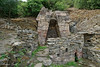
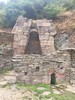
Reconstructed Nuragic huts, complete with pointy roofs.
Note: Exact GPS Position from handheld GPS Device.
You may be viewing yesterday's version of this page. To see the most up to date information please register for a free account.
")
Do not use the above information on other web sites or publications without permission of the contributor.
Nearby Images from Flickr

The above images may not be of the site on this page, but were taken nearby. They are loaded from Flickr so please click on them for image credits.
Click here to see more info for this site
Nearby sites
Click here to view sites on an interactive map of the areaKey: Red: member's photo, Blue: 3rd party photo, Yellow: other image, Green: no photo - please go there and take one, Grey: site destroyed
Download sites to:
KML (Google Earth)
GPX (GPS waypoints)
CSV (Garmin/Navman)
CSV (Excel)
To unlock full downloads you need to sign up as a Contributory Member. Otherwise downloads are limited to 50 sites.
Turn off the page maps and other distractions
Nearby sites listing. In the following links * = Image available
67m NE 56° Su Tempiesu Pozzo Sacro* Holy Well or Sacred Spring
1.0km NE 40° Santa Lula Nuraghe* Broch or Nuraghe
4.8km SSE 156° Lottoai Domus de Janas Rock Cut Tomb
6.6km ESE 118° Luarzu Nuraghe* Broch or Nuraghe
6.9km S 181° Iacupiu Nuraghe Broch or Nuraghe
7.2km E 99° Puzzittu Nuraghe Broch or Nuraghe
8.4km NNE 15° San Pietro Nuraghe (Onani)* Broch or Nuraghe
9.4km ESE 112° S'Ena'e Thomes Tomba di Giganti* Chambered Tomb
10.8km SSE 166° Satzaresu Nuraghe* Broch or Nuraghe
10.9km S 185° Pirastru Tortu Nuraghe Broch or Nuraghe
11.1km WSW 257° Complesso nuragico di Noddule* Ancient Village or Settlement
11.3km SSE 147° Biriai Menhirs* Standing Stones
12.7km SE 136° Lottoniddo Tomba di Giganti Chambered Tomb
13.3km SW 214° Tanca Manna Nuraghe (Nuoro)* Broch or Nuraghe
13.6km SE 129° Serra Orrios Tempio delle Riunione* Ancient Temple
13.6km SE 129° Serra Orrios Megaron* Ancient Temple
13.6km SE 129° Serra Orrios Temple* Ancient Temple
13.6km SE 129° Serra Orrios Villaggio Nuragico* Ancient Village or Settlement
13.7km SE 131° Oveni Nuraghe* Broch or Nuraghe
14.3km SE 133° Noriolo Nuraghe* Broch or Nuraghe
14.4km SE 125° Biristeddi Tomba di Giganti* Chambered Tomb
14.4km SE 125° Purgatoriu Villaggio Nuragico* Ancient Village or Settlement
14.5km SE 126° Purgatoriu Nuraghe* Broch or Nuraghe
14.6km SW 215° Tortilo Nuraghe Broch or Nuraghe
14.6km E 96° Calistru Nuraghe Broch or Nuraghe
View more nearby sites and additional images


 We would like to know more about this location. Please feel free to add a brief description and any relevant information in your own language.
 Wir möchten mehr über diese Stätte erfahren. Bitte zögern Sie nicht, eine kurze Beschreibung und relevante Informationen in Deutsch hinzuzufügen.
 Nous aimerions en savoir encore un peu sur les lieux. S'il vous plaît n'hesitez pas à ajouter une courte description et tous les renseignements pertinents dans votre propre langue.
 Quisieramos informarnos un poco más de las lugares. No dude en añadir una breve descripción y otros datos relevantes en su propio idioma.