

<< Our Photo Pages >> Sass del Pariuliin - Rock Art in Italy in Lombardia
Submitted by CoppellaiaMatta on Tuesday, 09 April 2024 Page Views: 25
Multi-periodSite Name: Sass del PariuliinCountry: Italy
NOTE: This site is 2.982 km away from the location you searched for.
Region: Lombardia Type: Rock Art
Nearest Village: Chiavenna
Latitude: 46.431776N Longitude: 9.349036E
Condition:
| 5 | Perfect |
| 4 | Almost Perfect |
| 3 | Reasonable but with some damage |
| 2 | Ruined but still recognisable as an ancient site |
| 1 | Pretty much destroyed, possibly visible as crop marks |
| 0 | No data. |
| -1 | Completely destroyed |
| 5 | Superb |
| 4 | Good |
| 3 | Ordinary |
| 2 | Not Good |
| 1 | Awful |
| 0 | No data. |
| 5 | Can be driven to, probably with disabled access |
| 4 | Short walk on a footpath |
| 3 | Requiring a bit more of a walk |
| 2 | A long walk |
| 1 | In the middle of nowhere, a nightmare to find |
| 0 | No data. |
| 5 | co-ordinates taken by GPS or official recorded co-ordinates |
| 4 | co-ordinates scaled from a detailed map |
| 3 | co-ordinates scaled from a bad map |
| 2 | co-ordinates of the nearest village |
| 1 | co-ordinates of the nearest town |
| 0 | no data |
Internal Links:
External Links:
")
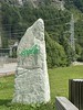
Ok. There is only one single cup mark on this rock, but it really is put to very good use with a little help from the natural features of the stone (was it a lesson on how to maximize results with minimal effort?).
There is a miniature reservoir at the centre of the stone, when it overflows the liquid mainly follows the natural groove that leads it to the bottom edge of the rock.
But if there's enough water, some of it is captured in an artificial channel and driven towards the cup mark. From the cup mark the water continues down to the edge of the stone where a tiny cut guides it right on top of the water coming from the natural groove.
What was divided is reunited....before crashing to the ground, I suppose.
I'm very fond of this stone: it's the first one I've stumbled upon since I started paying attention to this traces of history.
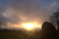
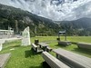
The location is superb, near an ancient bridleway and a step away from a deep ravine, with views over the Spluga valley and its mountains.
The water show is simple but effective. Very difficult to show in a photo, though. So I've put brush to paper and I've given the water the most impressive blue. Can't be missed.
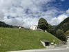
The stone is found at the edge of Mottaccio, a pasture above Madesimo and is one of many in the borough.
You may be viewing yesterday's version of this page. To see the most up to date information please register for a free account.
")
Do not use the above information on other web sites or publications without permission of the contributor.
Nearby Images from Flickr
The above images may not be of the site on this page, but were taken nearby. They are loaded from Flickr so please click on them for image credits.
Click here to see more info for this site
Nearby sites
Click here to view sites on an interactive map of the areaKey: Red: member's photo, Blue: 3rd party photo, Yellow: other image, Green: no photo - please go there and take one, Grey: site destroyed
Download sites to:
KML (Google Earth)
GPX (GPS waypoints)
CSV (Garmin/Navman)
CSV (Excel)
To unlock full downloads you need to sign up as a Contributory Member. Otherwise downloads are limited to 50 sites.
Turn off the page maps and other distractions
Nearby sites listing. In the following links * = Image available
1.4km NNE 21° I sassi del Camanin* Rock Art
3.5km NE 38° Val Sterla* Rock Art
4.9km NNE 21° La Corte* Rock Art
9.9km WSW 245° Mesocco-Andergia Lepontische Stele Sculptured Stone
12.4km SSE 147° Dasile* Rock Art
12.9km SSE 158° Parco Marmitte dei Giganti* Ancient Mine, Quarry or other Industry
16.5km ESE 122° Sasc di Pè (Foot soles slab)* Rock Art
18.9km SE 146° Cairns at St Moritz* Cairn
19.0km NNE 18° Anselmo Gadola Collection* Museum
20.7km ESE 119° Masso-Avello Stampa* NOT SET
23.2km SW 219° Capèla dèla Riva Rock Art
23.3km SW 219° Sass de l'Orch Wackelstein Rock Art
23.3km SW 220° Verdabbio Schalensteingebiet* Rock Art
24.3km SW 215° Sass Pagan (Pagan stone)* Rock Art
27.1km SW 219° Carasole San Rocco* Rock Art
27.2km E 97° Maloja Stone with ornaments* Rock Art
27.2km E 97° Maloja Mortar Stone* Rock Art
27.4km NE 49° Tinizong Senslas Rock Art
30.4km NNE 16° Carschenna* Rock Art
31.8km SW 233° Claro sito preistorico Standing Stone (Menhir)
34.0km N 9° Cazis Petrushügel* Ancient Village or Settlement
36.4km SE 139° San Giuseppe* Rock Art
39.1km ENE 78° Druidenstein St. Moritz* Natural Stone / Erratic / Other Natural Feature
41.0km NNW 343° Crest la Cuppa Rock Art
41.0km NNW 347° Crap de Pops Natural Stone / Erratic / Other Natural Feature
View more nearby sites and additional images


 We would like to know more about this location. Please feel free to add a brief description and any relevant information in your own language.
 Wir möchten mehr über diese Stätte erfahren. Bitte zögern Sie nicht, eine kurze Beschreibung und relevante Informationen in Deutsch hinzuzufügen.
 Nous aimerions en savoir encore un peu sur les lieux. S'il vous plaît n'hesitez pas à ajouter une courte description et tous les renseignements pertinents dans votre propre langue.
 Quisieramos informarnos un poco más de las lugares. No dude en añadir una breve descripción y otros datos relevantes en su propio idioma.