


<< Text Pages >> Alvaro Musca Nuraghe - Broch or Nuraghe in Italy in Sardinia (Sardegna)
Submitted by SolarMegalith on Friday, 12 November 2010 Page Views: 1640
Neolithic and Bronze AgeSite Name: Alvaro Musca Nuraghe Alternative Name: Nuraghe Sa ConcheddaCountry: Italy
NOTE: This site is 1.271 km away from the location you searched for.
Region: Sardinia (Sardegna) Type: Broch or Nuraghe
Nearest Town: Oschiri
Latitude: 40.720821N Longitude: 9.085954E
Condition:
| 5 | Perfect |
| 4 | Almost Perfect |
| 3 | Reasonable but with some damage |
| 2 | Ruined but still recognisable as an ancient site |
| 1 | Pretty much destroyed, possibly visible as crop marks |
| 0 | No data. |
| -1 | Completely destroyed |
| 5 | Superb |
| 4 | Good |
| 3 | Ordinary |
| 2 | Not Good |
| 1 | Awful |
| 0 | No data. |
| 5 | Can be driven to, probably with disabled access |
| 4 | Short walk on a footpath |
| 3 | Requiring a bit more of a walk |
| 2 | A long walk |
| 1 | In the middle of nowhere, a nightmare to find |
| 0 | No data. |
| 5 | co-ordinates taken by GPS or official recorded co-ordinates |
| 4 | co-ordinates scaled from a detailed map |
| 3 | co-ordinates scaled from a bad map |
| 2 | co-ordinates of the nearest village |
| 1 | co-ordinates of the nearest town |
| 0 | no data |
Internal Links:
External Links:
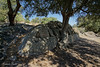
Nuraghe in Sardinia (Sardegna)
Remains of a nuraghe west of Oschiri.
You may be viewing yesterday's version of this page. To see the most up to date information please register for a free account.
Do not use the above information on other web sites or publications without permission of the contributor.
Nearby Images from Flickr

The above images may not be of the site on this page, but were taken nearby. They are loaded from Flickr so please click on them for image credits.
Click here to see more info for this site
Nearby sites
Click here to view sites on an interactive map of the areaKey: Red: member's photo, Blue: 3rd party photo, Yellow: other image, Green: no photo - please go there and take one, Grey: site destroyed
Download sites to:
KML (Google Earth)
GPX (GPS waypoints)
CSV (Garmin/Navman)
CSV (Excel)
To unlock full downloads you need to sign up as a Contributory Member. Otherwise downloads are limited to 50 sites.
Turn off the page maps and other distractions
Nearby sites listing. In the following links * = Image available
2.6km ESE 111° Lugheria Nuraghe Broch or Nuraghe
2.7km SE 130° Mastru Franziscu Nuraghe Broch or Nuraghe
3.5km SSE 165° Sinnadolzos Nuraghe Broch or Nuraghe
4.4km WSW 246° San Simeone Nuraghe* Broch or Nuraghe
4.8km SSW 196° Baccas Alvas Nuraghe* Broch or Nuraghe
5.9km W 272° Pigalva Nuraghe* Broch or Nuraghe
7.2km ENE 74° Malghesi Domus de Janas* Rock Cut Tomb
7.4km NE 34° Monte Acuto Dolmen Burial Chamber or Dolmen
7.6km ENE 72° S'Arroccu Nuraghe Broch or Nuraghe
11.1km WSW 247° Burghidu Nuraghe* Broch or Nuraghe
11.9km W 264° Montiju Coronas Dolmen* Burial Chamber or Dolmen
13.2km W 273° Zappareddu Nuraghe Broch or Nuraghe
14.7km SSW 214° Sa Mandra 'e sa Jua* Broch or Nuraghe
15.4km WNW 299° Pubattu Nuraghe* Broch or Nuraghe
15.6km NW 312° Majore Nuraghe* Broch or Nuraghe
15.7km WNW 295° Ispiene Nuraghe Broch or Nuraghe
15.8km W 268° Punta de S'Arroccu Muraglia Megalitica* Stone Fort or Dun
16.3km NW 316° Casteddu Petrusu Nuraghe* Broch or Nuraghe
16.3km NW 310° Filiziu Protonuraghe* Broch or Nuraghe
16.5km WNW 285° Su Agantinu Nuraghe* Broch or Nuraghe
16.6km SSE 156° Lerno Nuraghe Broch or Nuraghe
16.6km WNW 286° Monte Sozu Tomba di Giganti (2)* Chambered Tomb
16.6km W 269° Elighia Nuraghe* Broch or Nuraghe
16.6km WNW 287° Su Casteddu Nuraghe* Broch or Nuraghe
16.6km WNW 297° Puligosu Nuraghe Broch or Nuraghe
View more nearby sites and additional images


 We would like to know more about this location. Please feel free to add a brief description and any relevant information in your own language.
 Wir möchten mehr über diese Stätte erfahren. Bitte zögern Sie nicht, eine kurze Beschreibung und relevante Informationen in Deutsch hinzuzufügen.
 Nous aimerions en savoir encore un peu sur les lieux. S'il vous plaît n'hesitez pas à ajouter une courte description et tous les renseignements pertinents dans votre propre langue.
 Quisieramos informarnos un poco más de las lugares. No dude en añadir una breve descripción y otros datos relevantes en su propio idioma.