

<< Text Pages >> Grabhügel Berlebecker Heide - Round Barrow(s) in Germany in North Rhine-Westphalia
Submitted by Harald_Platta on Tuesday, 16 August 2016 Page Views: 680
Neolithic and Bronze AgeSite Name: Grabhügel Berlebecker Heide Alternative Name: Detmold Denkmalnummer 41Country: Germany
NOTE: This site is 0.733 km away from the location you searched for.
Land: North Rhine-Westphalia Type: Round Barrow(s)
Nearest Town: Detmold
Latitude: 51.876445N Longitude: 8.869162E
Condition:
| 5 | Perfect |
| 4 | Almost Perfect |
| 3 | Reasonable but with some damage |
| 2 | Ruined but still recognisable as an ancient site |
| 1 | Pretty much destroyed, possibly visible as crop marks |
| 0 | No data. |
| -1 | Completely destroyed |
| 5 | Superb |
| 4 | Good |
| 3 | Ordinary |
| 2 | Not Good |
| 1 | Awful |
| 0 | No data. |
| 5 | Can be driven to, probably with disabled access |
| 4 | Short walk on a footpath |
| 3 | Requiring a bit more of a walk |
| 2 | A long walk |
| 1 | In the middle of nowhere, a nightmare to find |
| 0 | No data. |
| 5 | co-ordinates taken by GPS or official recorded co-ordinates |
| 4 | co-ordinates scaled from a detailed map |
| 3 | co-ordinates scaled from a bad map |
| 2 | co-ordinates of the nearest village |
| 1 | co-ordinates of the nearest town |
| 0 | no data |
Be the first person to rate this site - see the 'Contribute!' box in the right hand menu.
Internal Links:
External Links:
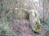
The Grabhügel Berlebecker Heide is a round barrow in Detmold (North Rhine-Westphalia, Germany).
Reference:
[01] Stadt Detmold: Liste der Bodendenkmäler in Detmold (Stand April 2013).
You may be viewing yesterday's version of this page. To see the most up to date information please register for a free account.
Do not use the above information on other web sites or publications without permission of the contributor.
Nearby Images from Flickr
The above images may not be of the site on this page, but were taken nearby. They are loaded from Flickr so please click on them for image credits.
Click here to see more info for this site
Nearby sites
Click here to view sites on an interactive map of the areaKey: Red: member's photo, Blue: 3rd party photo, Yellow: other image, Green: no photo - please go there and take one, Grey: site destroyed
Download sites to:
KML (Google Earth)
GPX (GPS waypoints)
CSV (Garmin/Navman)
CSV (Excel)
To unlock full downloads you need to sign up as a Contributory Member. Otherwise downloads are limited to 50 sites.
Turn off the page maps and other distractions
Nearby sites listing. In the following links * = Image available
2.8km N 8° Grabhügelgruppe Recke Round Barrow(s)
3.0km NE 37° Grabhügel Im Wallberge Round Barrow(s)
3.4km ESE 104° Externsteine* Rock Outcrop
3.4km NNW 347° Grabhügelgruppe In der Steinbreite Barrow Cemetery
3.6km NNE 15° Siedlungsplatz der mittleren Steinzeit Im Niedernkampe Ancient Village or Settlement
4.0km NNE 20° Grabhügel Großer Stenderbusch Round Barrow(s)
4.4km NNW 335° Wallburg Großer Hünenring* Hillfort
4.5km NNE 32° Grabhügelgruppe Großer Schneiderbusch Round Barrow(s)
4.5km NE 52° Grabhügel Auf dem Osterberge Round Barrow(s)
4.6km SSW 206° Oesterholz Huegelgraeberfeld* Barrow Cemetery
4.7km N 3° Grabhügelgruppe Friedrichshöhe Barrow Cemetery
4.8km N 357° Grabhügelgruppe Buchenberg Round Barrow(s)
5.0km NNW 329° Grabhügel Oberes Martsiek Round Barrow(s)
5.6km ENE 58° Grabhügelgruppe Bannenberg Round Barrow(s)
5.7km NNW 329° Grabhügel Sternschanze Round Barrow(s)
6.2km SSW 197° Kohlstaedt Huegelgraeberfeld* Barrow Cemetery
6.7km NNW 333° Grabhügelgruppe Bent Barrow Cemetery
6.7km NNW 342° Grabhügel Vietberg I Round Barrow(s)
6.8km N 4° Lippisches Landesmuseum* Museum
6.8km NW 324° Grabhügelgruppe Kahler Ehberg Round Barrow(s)
6.9km NNW 341° Grabhügelgruppe Vietberg* Round Barrow(s)
7.0km ENE 58° Grabhügel Im Ellern Round Barrow(s)
7.0km NNW 340° Grabhügel Vietberg II Round Barrow(s)
7.1km NW 321° Grabhügelgruppe Weginghauser Bruch* Barrow Cemetery
7.1km SE 124° Steinlabyrinth Velmerstot* Turf Maze
View more nearby sites and additional images


 We would like to know more about this location. Please feel free to add a brief description and any relevant information in your own language.
 Wir möchten mehr über diese Stätte erfahren. Bitte zögern Sie nicht, eine kurze Beschreibung und relevante Informationen in Deutsch hinzuzufügen.
 Nous aimerions en savoir encore un peu sur les lieux. S'il vous plaît n'hesitez pas à ajouter une courte description et tous les renseignements pertinents dans votre propre langue.
 Quisieramos informarnos un poco más de las lugares. No dude en añadir una breve descripción y otros datos relevantes en su propio idioma.