 with our Megalithic Portal iPhone app")


<< Text Pages >> Don Michele Nuraghe - Broch or Nuraghe in Italy in Sardinia (Sardegna)
Submitted by SolarMegalith on Monday, 17 September 2012 Page Views: 1194
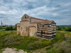
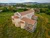
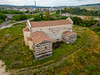
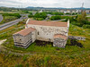
Neolithic and Bronze AgeSite Name: Don Michele NuragheCountry: Italy
NOTE: This site is 0.882 km away from the location you searched for.
Region: Sardinia (Sardegna) Type: Broch or Nuraghe
Nearest Town: Ploaghe
Latitude: 40.666134N Longitude: 8.739569E
Condition:
| 5 | Perfect |
| 4 | Almost Perfect |
| 3 | Reasonable but with some damage |
| 2 | Ruined but still recognisable as an ancient site |
| 1 | Pretty much destroyed, possibly visible as crop marks |
| 0 | No data. |
| -1 | Completely destroyed |
| 5 | Superb |
| 4 | Good |
| 3 | Ordinary |
| 2 | Not Good |
| 1 | Awful |
| 0 | No data. |
| 5 | Can be driven to, probably with disabled access |
| 4 | Short walk on a footpath |
| 3 | Requiring a bit more of a walk |
| 2 | A long walk |
| 1 | In the middle of nowhere, a nightmare to find |
| 0 | No data. |
| 5 | co-ordinates taken by GPS or official recorded co-ordinates |
| 4 | co-ordinates scaled from a detailed map |
| 3 | co-ordinates scaled from a bad map |
| 2 | co-ordinates of the nearest village |
| 1 | co-ordinates of the nearest town |
| 0 | no data |
Internal Links:
External Links:
Nuraghe in Sardinia (Sardegna)
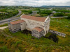
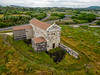
Ruins of Nuraghe Don Michele are located in northern part of Ploaghe. Lower parts of the walls with polygonal cyclopean masonry are well-preserved.
You may be viewing yesterday's version of this page. To see the most up to date information please register for a free account.
Do not use the above information on other web sites or publications without permission of the contributor.
Nearby Images from Flickr
The above images may not be of the site on this page, but were taken nearby. They are loaded from Flickr so please click on them for image credits.
Click here to see more info for this site
Nearby sites
Click here to view sites on an interactive map of the areaKey: Red: member's photo, Blue: 3rd party photo, Yellow: other image, Green: no photo - please go there and take one, Grey: site destroyed
Download sites to:
KML (Google Earth)
GPX (GPS waypoints)
CSV (Garmin/Navman)
CSV (Excel)
To unlock full downloads you need to sign up as a Contributory Member. Otherwise downloads are limited to 50 sites.
Turn off the page maps and other distractions
Nearby sites listing. In the following links * = Image available
628m SSW 204° Attentu Nuraghe* Broch or Nuraghe
987m SW 229° Curzu Nuraghe* Broch or Nuraghe
1.7km NW 312° Santuzzu Nuraghe Broch or Nuraghe
2.1km ENE 75° Soddu Nuraghe* Broch or Nuraghe
2.9km SW 225° Palaesi Nuraghe Broch or Nuraghe
2.9km SSW 213° Figosu Nuraghe Broch or Nuraghe
4.2km ENE 72° Martine Nuraghe* Broch or Nuraghe
4.3km WNW 296° Nieddu Nuraghe (Codrongianos)* Broch or Nuraghe
4.6km WNW 282° Su Crabile Nuraghe* Broch or Nuraghe
4.9km NNE 28° Monte Frusciu Nuraghe* Broch or Nuraghe
5.0km N 352° Fontana Sa Rena Nuraghe Broch or Nuraghe
5.2km NNE 32° Su Idighinzu Nuraghe* Broch or Nuraghe
5.2km SW 229° S'Ispagnolu Nuraghe Broch or Nuraghe
5.3km WSW 243° Santu Nicola Nuraghe Broch or Nuraghe
5.4km SW 223° Ozzastru Nuraghe (Codrongianos) Broch or Nuraghe
6.0km NNW 333° Pireddu Nuraghe Broch or Nuraghe
6.2km NNW 326° Pabale Nuraghe Broch or Nuraghe
6.7km S 181° Morette Nuraghe* Broch or Nuraghe
6.9km WSW 257° Cantaru Ena Nuraghe* Broch or Nuraghe
7.0km WSW 242° Pala Binza Manna Nuraghe* Broch or Nuraghe
7.1km NW 322° Baiolu Nuraghe Broch or Nuraghe
7.2km NW 316° Pala Martine Nuraghe Broch or Nuraghe
7.2km W 265° Sas Coas Nuraghe Broch or Nuraghe
7.5km WSW 252° Monte Sorighe Nuraghe Broch or Nuraghe
7.8km NE 35° Conca de Zuighe Nuraghe* Broch or Nuraghe
View more nearby sites and additional images


 We would like to know more about this location. Please feel free to add a brief description and any relevant information in your own language.
 Wir möchten mehr über diese Stätte erfahren. Bitte zögern Sie nicht, eine kurze Beschreibung und relevante Informationen in Deutsch hinzuzufügen.
 Nous aimerions en savoir encore un peu sur les lieux. S'il vous plaît n'hesitez pas à ajouter une courte description et tous les renseignements pertinents dans votre propre langue.
 Quisieramos informarnos un poco más de las lugares. No dude en añadir una breve descripción y otros datos relevantes en su propio idioma.