


<< Text Pages >> Is Ulmus Nuraghe - Broch or Nuraghe in Italy in Sardinia (Sardegna)
Submitted by SolarMegalith on Thursday, 17 November 2011 Page Views: 1639
Neolithic and Bronze AgeSite Name: Is Ulmus NuragheCountry: Italy
NOTE: This site is 1.094 km away from the location you searched for.
Region: Sardinia (Sardegna) Type: Broch or Nuraghe
Nearest Village: Piscinas
Latitude: 39.077675N Longitude: 8.654240E
Condition:
| 5 | Perfect |
| 4 | Almost Perfect |
| 3 | Reasonable but with some damage |
| 2 | Ruined but still recognisable as an ancient site |
| 1 | Pretty much destroyed, possibly visible as crop marks |
| 0 | No data. |
| -1 | Completely destroyed |
| 5 | Superb |
| 4 | Good |
| 3 | Ordinary |
| 2 | Not Good |
| 1 | Awful |
| 0 | No data. |
| 5 | Can be driven to, probably with disabled access |
| 4 | Short walk on a footpath |
| 3 | Requiring a bit more of a walk |
| 2 | A long walk |
| 1 | In the middle of nowhere, a nightmare to find |
| 0 | No data. |
| 5 | co-ordinates taken by GPS or official recorded co-ordinates |
| 4 | co-ordinates scaled from a detailed map |
| 3 | co-ordinates scaled from a bad map |
| 2 | co-ordinates of the nearest village |
| 1 | co-ordinates of the nearest town |
| 0 | no data |
Internal Links:
External Links:
Nuraghe in Sardinia (Sardegna)
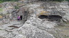
Partly overgrown, remains of this tholos-style nuraghe are located 600 m west from Piscinas, near a farmstead.
You may be viewing yesterday's version of this page. To see the most up to date information please register for a free account.
Do not use the above information on other web sites or publications without permission of the contributor.
Nearby Images from Flickr

The above images may not be of the site on this page, but were taken nearby. They are loaded from Flickr so please click on them for image credits.
Click here to see more info for this site
Nearby sites
Click here to view sites on an interactive map of the areaKey: Red: member's photo, Blue: 3rd party photo, Yellow: other image, Green: no photo - please go there and take one, Grey: site destroyed
Download sites to:
KML (Google Earth)
GPX (GPS waypoints)
CSV (Garmin/Navman)
CSV (Excel)
To unlock full downloads you need to sign up as a Contributory Member. Otherwise downloads are limited to 50 sites.
Turn off the page maps and other distractions
Nearby sites listing. In the following links * = Image available
2.4km E 101° Corongiu Longus Nuraghe Broch or Nuraghe
2.8km NE 51° Sanna Nuraghe* Broch or Nuraghe
3.2km NNE 24° Luxia Arrabiosa* Standing Stone (Menhir)
3.4km ENE 64° Pani Loriga* Ancient Village or Settlement
3.4km NNE 15° Niedda Nuraghe Broch or Nuraghe
3.6km NNE 25° Is Pedras Crocadas Menhirs* Stone Row / Alignment
3.9km NNE 33° Is Pireddas Menhir* Standing Stone (Menhir)
4.0km NNE 22° S'Arriorgiu Nuraghe* Broch or Nuraghe
5.4km SW 234° Cambulas Nuraghe Broch or Nuraghe
6.1km N 7° Su Angioni Nuraghe* Broch or Nuraghe
6.3km NNE 13° Corona Sa Figu Nuraghe* Broch or Nuraghe
6.3km N 11° Montessu Necropolis* Rock Cut Tomb
7.4km W 267° Monte di Palma Nuraghe Broch or Nuraghe
7.7km W 269° Trullu Nuraghe Broch or Nuraghe
7.8km WNW 295° Tratalias Nuraghe* Broch or Nuraghe
8.0km S 188° Arresi Nuraghe* Broch or Nuraghe
8.5km NNW 339° Sa Idda Nuraghe* Broch or Nuraghe
8.8km E 91° Cirixi Nuraghe Broch or Nuraghe
9.2km N 352° Pesus Nuraghe* Broch or Nuraghe
9.4km NE 52° Tattinu Villaggio Nuragico* Ancient Village or Settlement
9.4km NE 52° Tattinu Pozzo Sacro* Holy Well or Sacred Spring
9.4km S 189° Coi Casu Villaggio Nuragico Ancient Village or Settlement
9.5km NE 35° Pranedda Domus de Janas* Rock Cut Tomb
9.7km WNW 284° Candelargiu Nuraghe* Broch or Nuraghe
9.7km NE 36° Ega Is Marsinis Nuraghe* Broch or Nuraghe
View more nearby sites and additional images


 We would like to know more about this location. Please feel free to add a brief description and any relevant information in your own language.
 Wir möchten mehr über diese Stätte erfahren. Bitte zögern Sie nicht, eine kurze Beschreibung und relevante Informationen in Deutsch hinzuzufügen.
 Nous aimerions en savoir encore un peu sur les lieux. S'il vous plaît n'hesitez pas à ajouter une courte description et tous les renseignements pertinents dans votre propre langue.
 Quisieramos informarnos un poco más de las lugares. No dude en añadir una breve descripción y otros datos relevantes en su propio idioma.