


<< Our Photo Pages >> Paba de Soli Nuraghe - Broch or Nuraghe in Italy in Sardinia (Sardegna)
Submitted by francescomanconi on Sunday, 07 October 2012 Page Views: 1494
Neolithic and Bronze AgeSite Name: Paba de Soli NuragheCountry: Italy
NOTE: This site is 8.773 km away from the location you searched for.
Region: Sardinia (Sardegna) Type: Broch or Nuraghe
Nearest Town: Oristano Nearest Village: Siamanna
Latitude: 39.911944N Longitude: 8.745833E
Condition:
| 5 | Perfect |
| 4 | Almost Perfect |
| 3 | Reasonable but with some damage |
| 2 | Ruined but still recognisable as an ancient site |
| 1 | Pretty much destroyed, possibly visible as crop marks |
| 0 | No data. |
| -1 | Completely destroyed |
| 5 | Superb |
| 4 | Good |
| 3 | Ordinary |
| 2 | Not Good |
| 1 | Awful |
| 0 | No data. |
| 5 | Can be driven to, probably with disabled access |
| 4 | Short walk on a footpath |
| 3 | Requiring a bit more of a walk |
| 2 | A long walk |
| 1 | In the middle of nowhere, a nightmare to find |
| 0 | No data. |
| 5 | co-ordinates taken by GPS or official recorded co-ordinates |
| 4 | co-ordinates scaled from a detailed map |
| 3 | co-ordinates scaled from a bad map |
| 2 | co-ordinates of the nearest village |
| 1 | co-ordinates of the nearest town |
| 0 | no data |
Internal Links:
External Links:
")
A nuraghe presenting one tower (monotorre). The tholos of the chamber has collapsed.
You may be viewing yesterday's version of this page. To see the most up to date information please register for a free account.
")
")
Do not use the above information on other web sites or publications without permission of the contributor.
Nearby Images from Flickr

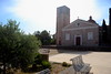
The above images may not be of the site on this page, but were taken nearby. They are loaded from Flickr so please click on them for image credits.
Click here to see more info for this site
Nearby sites
Click here to view sites on an interactive map of the areaKey: Red: member's photo, Blue: 3rd party photo, Yellow: other image, Green: no photo - please go there and take one, Grey: site destroyed
Download sites to:
KML (Google Earth)
GPX (GPS waypoints)
CSV (Garmin/Navman)
CSV (Excel)
To unlock full downloads you need to sign up as a Contributory Member. Otherwise downloads are limited to 50 sites.
Turn off the page maps and other distractions
Nearby sites listing. In the following links * = Image available
5.9km N 356° Serra Laccus Nuraghe Broch or Nuraghe
9.3km N 6° Ruinas Nuraghe* Broch or Nuraghe
9.8km N 2° San Gemiliano Nuraghe* Broch or Nuraghe
9.9km N 357° Santa Barbara Nuraghe (Villanova Truschedu)* Broch or Nuraghe
10.0km NE 36° Is Domigheddas Domus de Janas Rock Cut Tomb
10.1km N 4° Su Crabu Nuraghe* Broch or Nuraghe
10.6km N 4° Dominigu Porru Nuraghe* Broch or Nuraghe
10.7km N 11° Pischina Andria Nuraghe* Broch or Nuraghe
10.9km N 2° Zoppianu Nuraghe* Broch or Nuraghe
11.3km ESE 111° Bioranu Nuraghe* Broch or Nuraghe
11.4km N 1° Nuraghe 'e Mesu Broch or Nuraghe
11.9km ESE 109° Friarosu Protonuraghe* Broch or Nuraghe
12.2km S 169° Sennixeddu Stazione Preistorica Ancient Mine, Quarry or other Industry
12.5km ENE 59° Arasseda Nuraghe Broch or Nuraghe
12.6km NE 36° Putzola Protonuraghe Broch or Nuraghe
12.7km E 89° Mesadda Domus de Janas* Rock Cut Tomb
12.9km ESE 106° Baduggiana Standing Stone (Menhir)
13.1km NNW 340° Mura Crabas Nuraghe* Broch or Nuraghe
13.2km ESE 108° Tuttiricchiu* Standing Stone (Menhir)
13.4km NNW 342° Mura Figus Nuraghe* Broch or Nuraghe
13.6km NNW 335° Mura Prochilis Nuraghe* Broch or Nuraghe
13.8km ESE 107° Curru Tundu* Standing Stones
13.9km ESE 107° Is Forrus Domus de Janas* Rock Cut Tomb
14.1km ENE 67° Sa Mura Nuraghe (Samugheo) Broch or Nuraghe
14.4km N 350° Mura Cuata Tomba di Giganti* Chambered Tomb
View more nearby sites and additional images


 We would like to know more about this location. Please feel free to add a brief description and any relevant information in your own language.
 Wir möchten mehr über diese Stätte erfahren. Bitte zögern Sie nicht, eine kurze Beschreibung und relevante Informationen in Deutsch hinzuzufügen.
 Nous aimerions en savoir encore un peu sur les lieux. S'il vous plaît n'hesitez pas à ajouter une courte description et tous les renseignements pertinents dans votre propre langue.
 Quisieramos informarnos un poco más de las lugares. No dude en añadir una breve descripción y otros datos relevantes en su propio idioma.