

<< Our Photo Pages >> Ringwall Dreibornskopf - Hillfort in Germany in Hesse
Submitted by KaiHofmann on Wednesday, 29 June 2016 Page Views: 883
Iron Age and Later PrehistorySite Name: Ringwall DreibornskopfCountry: Germany
NOTE: This site is 3.931 km away from the location you searched for.
Land: Hesse Type: Hillfort
Nearest Town: Wiesbaden Nearest Village: Kiedrich
Latitude: 50.073231N Longitude: 8.062136E
Condition:
| 5 | Perfect |
| 4 | Almost Perfect |
| 3 | Reasonable but with some damage |
| 2 | Ruined but still recognisable as an ancient site |
| 1 | Pretty much destroyed, possibly visible as crop marks |
| 0 | No data. |
| -1 | Completely destroyed |
| 5 | Superb |
| 4 | Good |
| 3 | Ordinary |
| 2 | Not Good |
| 1 | Awful |
| 0 | No data. |
| 5 | Can be driven to, probably with disabled access |
| 4 | Short walk on a footpath |
| 3 | Requiring a bit more of a walk |
| 2 | A long walk |
| 1 | In the middle of nowhere, a nightmare to find |
| 0 | No data. |
| 5 | co-ordinates taken by GPS or official recorded co-ordinates |
| 4 | co-ordinates scaled from a detailed map |
| 3 | co-ordinates scaled from a bad map |
| 2 | co-ordinates of the nearest village |
| 1 | co-ordinates of the nearest town |
| 0 | no data |
Internal Links:
External Links:
")
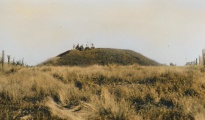
Small (56m diameter) iron age or early medieval hillfort. Today some ramparts and rock formations are still visible.
You may be viewing yesterday's version of this page. To see the most up to date information please register for a free account.
Do not use the above information on other web sites or publications without permission of the contributor.
Nearby Images from Flickr

The above images may not be of the site on this page, but were taken nearby. They are loaded from Flickr so please click on them for image credits.
Click here to see more info for this site
Nearby sites
Click here to view sites on an interactive map of the areaKey: Red: member's photo, Blue: 3rd party photo, Yellow: other image, Green: no photo - please go there and take one, Grey: site destroyed
Download sites to:
KML (Google Earth)
GPX (GPS waypoints)
CSV (Garmin/Navman)
CSV (Excel)
To unlock full downloads you need to sign up as a Contributory Member. Otherwise downloads are limited to 50 sites.
Turn off the page maps and other distractions
Nearby sites listing. In the following links * = Image available
8.5km E 95° Summstein Freudenberg Modern Stone Circle etc
10.4km NE 52° Altenstein Taunusstein Rock Outcrop
10.6km NE 51° Spitzenstein Taunusstein Rock Outcrop
10.7km S 176° Kaiserpfalz Ingelheim Ancient Palace
12.4km S 179° Hinkelstein Ober-Ingelheim Standing Stone (Menhir)
12.7km SSE 165° Wackernheim Menhir* Standing Stone (Menhir)
17.1km SSE 165° Elsheimer Bockstein Natural Stone / Erratic / Other Natural Feature
17.6km WSW 241° Alte Schanz Ohligs-Berg* Hillfort
18.8km SSE 155° Der Lange Stein Essenheim* Standing Stone (Menhir)
18.9km WNW 284° Grabhügel Weisel* Round Barrow(s)
20.6km NE 37° Holdersberg* Hillfort
21.6km NE 35° Ringwall Nack* Hillfort
22.9km NNE 12° Ringwall Altschloss* Hillfort
23.0km SE 127° Laubenheimer Stein* Standing Stone (Menhir)
23.0km SW 216° Grossgrabhügel Nekropole Langenlonsheim Barrow Cemetery
24.0km SW 229° Grabhügelfeld Grosse Heide Barrow Cemetery
24.4km SW 224° Wallburg Windesheim* Hillfort
24.6km SW 227° Grabhügelfeld Kleine Heide Barrow Cemetery
24.9km S 188° Wißberg Ancient Village or Settlement
25.1km SSE 166° Lange Stein von Obersaulheim* Standing Stone (Menhir)
25.2km WNW 290° Befestigung auf dem Hünenberg Hillfort
25.9km SSE 149° Selzen Menhir* Standing Stone (Menhir)
26.1km NE 36° Klingeschlag Siedlung Ancient Village or Settlement
26.3km SE 133° Der Lange Stein Nackenheim* Standing Stone (Menhir)
26.6km E 85° Grauer Stein Kapellenberg* Natural Stone / Erratic / Other Natural Feature
View more nearby sites and additional images


 We would like to know more about this location. Please feel free to add a brief description and any relevant information in your own language.
 Wir möchten mehr über diese Stätte erfahren. Bitte zögern Sie nicht, eine kurze Beschreibung und relevante Informationen in Deutsch hinzuzufügen.
 Nous aimerions en savoir encore un peu sur les lieux. S'il vous plaît n'hesitez pas à ajouter une courte description et tous les renseignements pertinents dans votre propre langue.
 Quisieramos informarnos un poco más de las lugares. No dude en añadir una breve descripción y otros datos relevantes en su propio idioma.