 with our Megalithic Portal iPhone app")

<< Our Photo Pages >> Ladak N' India - Ancient Temple in India
Submitted by motist on Saturday, 03 July 2010 Page Views: 7250
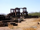
Multi-periodSite Name: Ladak N' IndiaCountry: India
NOTE: This site is 6.512 km away from the location you searched for.
Type: Ancient Temple
Nearest Town: Leh Nearest Village: Kthiksey
Latitude: 34.095308N Longitude: 77.603225E
Condition:
| 5 | Perfect |
| 4 | Almost Perfect |
| 3 | Reasonable but with some damage |
| 2 | Ruined but still recognisable as an ancient site |
| 1 | Pretty much destroyed, possibly visible as crop marks |
| 0 | No data. |
| -1 | Completely destroyed |
| 5 | Superb |
| 4 | Good |
| 3 | Ordinary |
| 2 | Not Good |
| 1 | Awful |
| 0 | No data. |
| 5 | Can be driven to, probably with disabled access |
| 4 | Short walk on a footpath |
| 3 | Requiring a bit more of a walk |
| 2 | A long walk |
| 1 | In the middle of nowhere, a nightmare to find |
| 0 | No data. |
| 5 | co-ordinates taken by GPS or official recorded co-ordinates |
| 4 | co-ordinates scaled from a detailed map |
| 3 | co-ordinates scaled from a bad map |
| 2 | co-ordinates of the nearest village |
| 1 | co-ordinates of the nearest town |
| 0 | no data |
Internal Links:
External Links:
")
Rock Carving in Ladak(Ladakh) on the border with Tibet
Stupa's , Mantras carved on big pebbles from the river Indus nearby,
on the road from Leh to Kthiksey Buddhist monestry
You may be viewing yesterday's version of this page. To see the most up to date information please register for a free account.
")
")
")
")
")
")
")
")
")
")
")
")
")
")
")
")
")
")
")
")
")
")
")
")
")
These are just the first 25 photos of Ladak N' India. If you log in with a free user account you will be able to see our entire collection.
Do not use the above information on other web sites or publications without permission of the contributor.
Click here to see more info for this site
Nearby sites
Click here to view sites on an interactive map of the areaKey: Red: member's photo, Blue: 3rd party photo, Yellow: other image, Green: no photo - please go there and take one, Grey: site destroyed
Download sites to:
KML (Google Earth)
GPX (GPS waypoints)
CSV (Garmin/Navman)
CSV (Excel)
To unlock full downloads you need to sign up as a Contributory Member. Otherwise downloads are limited to 50 sites.
Turn off the page maps and other distractions
Nearby sites listing. In the following links * = Image available
3.3km SE 134° Shey buddha engravings* Carving
6.1km NE 47° Saboo Rock* Rock Art
7.3km SE 127° Thiksey (Kthiksey) Buddhist monestry in Ladak* Ancient Temple
8.8km NNW 346° Maitreya Buddha and Avalokiteshvara rock carving* Sculptured Stone
9.8km SE 130° Nyerma Monastery* Ancient Temple
19.9km WNW 297° Taroo petroglyphs Rock Art
28.4km SSW 206° Markha valley Ladakh, Shorten's (Stupa's)* Ancient Temple
35.9km N 8° Kardung petroglyphs* Rock Art
40.3km WNW 289° Chilungtse altar stone Carving
41.9km WNW 290° Alchi Gompa* Ancient Temple
43.9km NNW 340° Camouflage Shield Stone* Rock Art
44.5km WNW 291° Alchi petroglyphs* Rock Art
50.3km N 355° Diskit petroglyphs* Rock Art
54.2km WNW 297° Hemis Shukpachan Menhir* Standing Stone (Menhir)
54.2km WNW 297° Hemis Shukpachen Palace* Ancient Palace
54.3km WNW 297° Hemis Shukpachan cup marked stone* Rock Art
54.4km WNW 297° Hemis Shukpachan engraved stone* Rock Art
56.0km NNW 346° Hundar Buddha sculptured stone* Rock Art
62.3km WNW 292° Nurla Petroglyphs Rock Art
67.0km SSE 166° TaglangLa Pass Buddhist road temple* Ancient Temple
75.5km N 355° Panamik Petroglyphs* Rock Art
75.9km WNW 291° Khalsi Petroglyphs Rock Art
84.2km WNW 294° Dhomkar Rock Art* Rock Art
118.0km WNW 286° Mulbekh Maitreya rock sculpture Sculptured Stone
206.9km S 191° Vashisht Temple Bowls* Ancient Temple
View more nearby sites and additional images


 We would like to know more about this location. Please feel free to add a brief description and any relevant information in your own language.
 Wir möchten mehr über diese Stätte erfahren. Bitte zögern Sie nicht, eine kurze Beschreibung und relevante Informationen in Deutsch hinzuzufügen.
 Nous aimerions en savoir encore un peu sur les lieux. S'il vous plaît n'hesitez pas à ajouter une courte description et tous les renseignements pertinents dans votre propre langue.
 Quisieramos informarnos un poco más de las lugares. No dude en añadir una breve descripción y otros datos relevantes en su propio idioma.