 with our Megalithic Portal iPhone app")
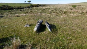

<< Other Photo Pages >> Oppidum du Castellar - Ancient Village or Settlement in France in Provence:Alpes-Maritimes (06)
Submitted by holger_rix on Sunday, 24 April 2016 Page Views: 1467
Multi-periodSite Name: Oppidum du Castellar Alternative Name: Mont BastideCountry: France
NOTE: This site is 2.017 km away from the location you searched for.
Département: Provence:Alpes-Maritimes (06) Type: Ancient Village or Settlement
Nearest Town: Nice Nearest Village: Èze
Latitude: 43.730303N Longitude: 7.350114E
Condition:
| 5 | Perfect |
| 4 | Almost Perfect |
| 3 | Reasonable but with some damage |
| 2 | Ruined but still recognisable as an ancient site |
| 1 | Pretty much destroyed, possibly visible as crop marks |
| 0 | No data. |
| -1 | Completely destroyed |
| 5 | Superb |
| 4 | Good |
| 3 | Ordinary |
| 2 | Not Good |
| 1 | Awful |
| 0 | No data. |
| 5 | Can be driven to, probably with disabled access |
| 4 | Short walk on a footpath |
| 3 | Requiring a bit more of a walk |
| 2 | A long walk |
| 1 | In the middle of nowhere, a nightmare to find |
| 0 | No data. |
| 5 | co-ordinates taken by GPS or official recorded co-ordinates |
| 4 | co-ordinates scaled from a detailed map |
| 3 | co-ordinates scaled from a bad map |
| 2 | co-ordinates of the nearest village |
| 1 | co-ordinates of the nearest town |
| 0 | no data |
Be the first person to rate this site - see the 'Contribute!' box in the right hand menu.
Internal Links:
External Links:
")
Èze, Nice, Alpes-Maritimes, Provence-Alpes-Côte d'Azur
Source: T4T35.fr
You may be viewing yesterday's version of this page. To see the most up to date information please register for a free account.
Do not use the above information on other web sites or publications without permission of the contributor.
Nearby Images from Flickr

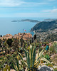
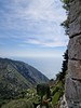
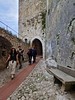
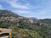
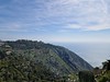
The above images may not be of the site on this page, but were taken nearby. They are loaded from Flickr so please click on them for image credits.
Click here to see more info for this site
Nearby sites
Click here to view sites on an interactive map of the areaKey: Red: member's photo, Blue: 3rd party photo, Yellow: other image, Green: no photo - please go there and take one, Grey: site destroyed
Download sites to:
KML (Google Earth)
GPX (GPS waypoints)
CSV (Garmin/Navman)
CSV (Excel)
To unlock full downloads you need to sign up as a Contributory Member. Otherwise downloads are limited to 50 sites.
Turn off the page maps and other distractions
Nearby sites listing. In the following links * = Image available
3.9km WNW 292° Rocher du Corbeau Round Barrow(s)
5.1km E 88° Musée d’Anthropologie Préhistorique* Museum
5.1km E 89° Grotte de l'Observatoire* Cave or Rock Shelter
5.8km WNW 286° Pyramid of Falicon Modern Stone Circle etc
6.3km SW 225° Grotte du Lazaret Cave or Rock Shelter
9.2km ENE 64° La Palmeraie Cave or Rock Shelter
10.4km ENE 69° Grotte du Vallonet Cave or Rock Shelter
11.0km ENE 71° Grotte du Repaire Cave or Rock Shelter
13.4km ENE 67° Musée de la Préhistoire régionale de Menton* Museum
14.4km WNW 284° Grotte de Perseguier Cave or Rock Shelter
16.0km ENE 68° Balzi Rossi* Cave or Rock Shelter
18.1km WSW 253° Saint-Veran Grotte Cave or Rock Shelter
18.7km W 273° Grotte Sepulcrale de L'Ibis Cave or Rock Shelter
19.1km W 271° Tumuli du Plan des Noves Artificial Mound
19.2km W 275° Dolmen des Blaquières Burial Chamber or Dolmen
19.4km NNE 20° Albarea Grotte Sepulcrale Cave or Rock Shelter
19.5km W 272° Grotte Sepulcrale Des Perles Cave or Rock Shelter
19.8km W 275° Grotte Sepulcrale du Fenestron Cave or Rock Shelter
20.7km W 272° Grotte Sepulcrale Chabert Cave or Rock Shelter
21.8km WSW 255° Grotte Bianchi Cave or Rock Shelter
22.1km W 265° Grotte Sepulcrale de L'Aigle Cave or Rock Shelter
22.2km N 2° Peire Cava Tumulus Artificial Mound
23.6km W 271° Le Caire Tumulus Artificial Mound
23.9km W 264° Baume Obscure Grotte Sepulcrale Cave or Rock Shelter
24.4km WSW 250° Grotte du Clos Cave or Rock Shelter
View more nearby sites and additional images


 We would like to know more about this location. Please feel free to add a brief description and any relevant information in your own language.
 Wir möchten mehr über diese Stätte erfahren. Bitte zögern Sie nicht, eine kurze Beschreibung und relevante Informationen in Deutsch hinzuzufügen.
 Nous aimerions en savoir encore un peu sur les lieux. S'il vous plaît n'hesitez pas à ajouter une courte description et tous les renseignements pertinents dans votre propre langue.
 Quisieramos informarnos un poco más de las lugares. No dude en añadir una breve descripción y otros datos relevantes en su propio idioma.