

<< Text Pages >> Kirschweiler Festung - Hillfort in Germany in Rhineland-Palatinate
Submitted by KaiHofmann on Tuesday, 22 June 2010 Page Views: 2587
Iron Age and Later PrehistorySite Name: Kirschweiler FestungCountry: Germany
NOTE: This site is 4.099 km away from the location you searched for.
Land: Rhineland-Palatinate Type: Hillfort
Nearest Town: Idar-Oberstein Nearest Village: Kirschweiler
Latitude: 49.759200N Longitude: 7.226900E
Condition:
| 5 | Perfect |
| 4 | Almost Perfect |
| 3 | Reasonable but with some damage |
| 2 | Ruined but still recognisable as an ancient site |
| 1 | Pretty much destroyed, possibly visible as crop marks |
| 0 | No data. |
| -1 | Completely destroyed |
| 5 | Superb |
| 4 | Good |
| 3 | Ordinary |
| 2 | Not Good |
| 1 | Awful |
| 0 | No data. |
| 5 | Can be driven to, probably with disabled access |
| 4 | Short walk on a footpath |
| 3 | Requiring a bit more of a walk |
| 2 | A long walk |
| 1 | In the middle of nowhere, a nightmare to find |
| 0 | No data. |
| 5 | co-ordinates taken by GPS or official recorded co-ordinates |
| 4 | co-ordinates scaled from a detailed map |
| 3 | co-ordinates scaled from a bad map |
| 2 | co-ordinates of the nearest village |
| 1 | co-ordinates of the nearest town |
| 0 | no data |
Internal Links:
External Links:
Hillfort in Rhineland-Palatinate
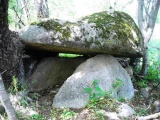
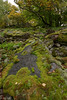
Old Celtic sanctuary. Later It was used as a Frankish Thing (Germanic meeting place).
Thousands of huge rocks are built up on the top of the mountain (Silberich)
You may be viewing yesterday's version of this page. To see the most up to date information please register for a free account.
Do not use the above information on other web sites or publications without permission of the contributor.
Nearby Images from Flickr

The above images may not be of the site on this page, but were taken nearby. They are loaded from Flickr so please click on them for image credits.
Click here to see more info for this site
Nearby sites
Click here to view sites on an interactive map of the areaKey: Red: member's photo, Blue: 3rd party photo, Yellow: other image, Green: no photo - please go there and take one, Grey: site destroyed
Download sites to:
KML (Google Earth)
GPX (GPS waypoints)
CSV (Garmin/Navman)
CSV (Excel)
To unlock full downloads you need to sign up as a Contributory Member. Otherwise downloads are limited to 50 sites.
Turn off the page maps and other distractions
Nearby sites listing. In the following links * = Image available
1.8km WSW 241° Allenbach Ringkopf Hillfort
2.8km NE 48° Wildenburg Hillfort
8.6km NNE 15° Hellertshausen Schimmerstein * Standing Stone (Menhir)
10.0km N 6° Quellheiligtum Hochscheid* Holy Well or Sacred Spring
10.6km WSW 257° Summstein Erbeskopf Modern Stone Circle etc
11.4km ENE 64° Hirtenboesch Grabhuegelfeld Barrow Cemetery
11.6km NW 325° Gonzerath Hügelgräber Round Barrow(s)
11.7km E 94° Keltenburg Fischbach Hillfort
11.9km NNW 343° Menhirgruppe am Archäologiepark Belginum* Standing Stones
12.0km NNW 343° Menhir am Archäologiepark Belginum* Standing Stone (Menhir)
12.0km NNW 333° Römergrab Wederath Round Barrow(s)
12.1km NNW 344° Wederath Hügelgräber III Round Barrow(s)
12.3km ENE 78° Grabhügelfeld Perchwald Barrow Cemetery
12.4km NNW 332° Wederath Grabhügel I Round Barrow(s)
12.6km WSW 246° Sigfrieds Quelle Erbeskopf Holy Well or Sacred Spring
12.6km NNW 332° Wederath Grabhügel II Round Barrow(s)
12.9km N 350° Grabhügelgruppe Hochscheid Barrow Cemetery
13.3km NW 315° Graue Ley* Natural Stone / Erratic / Other Natural Feature
13.7km WNW 296° Merscheid Römergrab Artificial Mound
13.8km E 92° Bremer Berg Hillfort
13.9km NNE 33° Rhaunen Koenigstein* Standing Stone (Menhir)
14.1km NNW 331° Hügelgraber Kommen Round Barrow(s)
14.4km NW 314° Heidenpuetz Holy Well or Sacred Spring
14.4km NW 311° Judenkirchhof Elzerath* Multiple Stone Rows / Avenue
15.5km NE 50° Keltensiedlung Altburg* Museum
View more nearby sites and additional images


 We would like to know more about this location. Please feel free to add a brief description and any relevant information in your own language.
 Wir möchten mehr über diese Stätte erfahren. Bitte zögern Sie nicht, eine kurze Beschreibung und relevante Informationen in Deutsch hinzuzufügen.
 Nous aimerions en savoir encore un peu sur les lieux. S'il vous plaît n'hesitez pas à ajouter une courte description et tous les renseignements pertinents dans votre propre langue.
 Quisieramos informarnos un poco más de las lugares. No dude en añadir una breve descripción y otros datos relevantes en su propio idioma.