


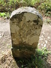
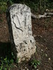
<< Our Photo Pages >> Brevilliers Dolmen - Burial Chamber or Dolmen in France in Franche:Haute-Saône (70)
Submitted by regina on Thursday, 28 September 2017 Page Views: 5105
Neolithic and Bronze AgeSite Name: Brevilliers Dolmen Alternative Name: Dolmen des Issières, la Pierre des GauloisCountry: France
NOTE: This site is 12.622 km away from the location you searched for.
Département: Franche:Haute-Saône (70) Type: Burial Chamber or Dolmen
Nearest Town: Belfort Nearest Village: Brevilliers
Latitude: 47.577610N Longitude: 6.800870E
Condition:
| 5 | Perfect |
| 4 | Almost Perfect |
| 3 | Reasonable but with some damage |
| 2 | Ruined but still recognisable as an ancient site |
| 1 | Pretty much destroyed, possibly visible as crop marks |
| 0 | No data. |
| -1 | Completely destroyed |
| 5 | Superb |
| 4 | Good |
| 3 | Ordinary |
| 2 | Not Good |
| 1 | Awful |
| 0 | No data. |
| 5 | Can be driven to, probably with disabled access |
| 4 | Short walk on a footpath |
| 3 | Requiring a bit more of a walk |
| 2 | A long walk |
| 1 | In the middle of nowhere, a nightmare to find |
| 0 | No data. |
| 5 | co-ordinates taken by GPS or official recorded co-ordinates |
| 4 | co-ordinates scaled from a detailed map |
| 3 | co-ordinates scaled from a bad map |
| 2 | co-ordinates of the nearest village |
| 1 | co-ordinates of the nearest town |
| 0 | no data |
Internal Links:
External Links:
")
Page originally by Alex Hunger
You may be viewing yesterday's version of this page. To see the most up to date information please register for a free account.
")
")
Do not use the above information on other web sites or publications without permission of the contributor.
Nearby Images from Flickr
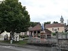

The above images may not be of the site on this page, but were taken nearby. They are loaded from Flickr so please click on them for image credits.
Click here to see more info for this site
Nearby sites
Click here to view sites on an interactive map of the areaKey: Red: member's photo, Blue: 3rd party photo, Yellow: other image, Green: no photo - please go there and take one, Grey: site destroyed
Download sites to:
KML (Google Earth)
GPX (GPS waypoints)
CSV (Garmin/Navman)
CSV (Excel)
To unlock full downloads you need to sign up as a Contributory Member. Otherwise downloads are limited to 50 sites.
Turn off the page maps and other distractions
Nearby sites listing. In the following links * = Image available
6.6km NW 320° Menhir dit la Pierre des Gaulois* Standing Stone (Menhir)
8.0km S 179° Megalithe Chantant Montbeliard (Summstein) Modern Stone Circle etc
14.3km S 181° Théâtre gallo-romain de Mandeure* Ancient Village or Settlement
18.0km SSE 159° Cromlech des Fourneaux* Stone Circle
29.1km SW 232° Santoches Dolmen* Burial Chamber or Dolmen
29.6km W 272° Dolmen du Bois de Blusseret 1* Burial Chamber or Dolmen
29.6km W 270° Dolmen du Bois de Blusseret 2 Burial Chamber or Dolmen
29.9km W 270° Dolmen du Bois de Blusseret 3 Burial Chamber or Dolmen
30.6km SE 128° Courgenay Pierre-Percée* Chambered Tomb
31.4km W 272° Oppenans burial chamber Burial Chamber or Dolmen
32.7km WSW 251° Dolmen du Mont-Roland Burial Chamber or Dolmen
33.6km NW 318° Pierre Mourey Natural Stone / Erratic / Other Natural Feature
33.9km WSW 248° Trou du Seri* Cave or Rock Shelter
34.0km WSW 248° Grotte aux Ours* Cave or Rock Shelter
35.5km ESE 112° Grotte du Mannlefelsen (Oberlarg)* Cave or Rock Shelter
36.9km ESE 103° Kastelberg Oppidium* Promontory Fort / Cliff Castle
42.2km W 276° Dolmen dit la Pierre qui Vire (Vesoul) Burial Chamber or Dolmen
42.3km SE 129° Bassecourt Menhir Standing Stone (Menhir)
44.6km ESE 107° Saint-Joseph Abri* Cave or Rock Shelter
45.5km ENE 69° Rixheim Tumulus* Artificial Mound
45.9km NE 37° Puppelestein de Rimbach* Rock Outcrop
46.3km NE 41° Heidenbuckel Menhir Standing Stone (Menhir)
46.7km NE 40° Dietrichstein* Rock Outcrop
48.9km NE 38° Appenthal Menhirs* Stone Row / Alignment
50.3km ESE 120° Pierre de Saint Germain* Rock Art
View more nearby sites and additional images


 We would like to know more about this location. Please feel free to add a brief description and any relevant information in your own language.
 Wir möchten mehr über diese Stätte erfahren. Bitte zögern Sie nicht, eine kurze Beschreibung und relevante Informationen in Deutsch hinzuzufügen.
 Nous aimerions en savoir encore un peu sur les lieux. S'il vous plaît n'hesitez pas à ajouter une courte description et tous les renseignements pertinents dans votre propre langue.
 Quisieramos informarnos un poco más de las lugares. No dude en añadir una breve descripción y otros datos relevantes en su propio idioma.