 with our Megalithic Portal iPhone app")


<< Our Photo Pages >> Solstice Sundial - Modern Stone Circle etc in France in Provence:Alpes-Maritimes (06)
Submitted by Andy B on Saturday, 14 July 2012 Page Views: 4220
Modern SitesSite Name: Solstice SundialCountry: France
NOTE: This site is 0.279 km away from the location you searched for.
Département: Provence:Alpes-Maritimes (06) Type: Modern Stone Circle etc
Nearest Town: Nice Nearest Village: Valbonne Sophia Antipolis
Latitude: 43.614887N Longitude: 7.051637E
Condition:
| 5 | Perfect |
| 4 | Almost Perfect |
| 3 | Reasonable but with some damage |
| 2 | Ruined but still recognisable as an ancient site |
| 1 | Pretty much destroyed, possibly visible as crop marks |
| 0 | No data. |
| -1 | Completely destroyed |
| 5 | Superb |
| 4 | Good |
| 3 | Ordinary |
| 2 | Not Good |
| 1 | Awful |
| 0 | No data. |
| 5 | Can be driven to, probably with disabled access |
| 4 | Short walk on a footpath |
| 3 | Requiring a bit more of a walk |
| 2 | A long walk |
| 1 | In the middle of nowhere, a nightmare to find |
| 0 | No data. |
| 5 | co-ordinates taken by GPS or official recorded co-ordinates |
| 4 | co-ordinates scaled from a detailed map |
| 3 | co-ordinates scaled from a bad map |
| 2 | co-ordinates of the nearest village |
| 1 | co-ordinates of the nearest town |
| 0 | no data |
Internal Links:
External Links:
I have visited· I would like to visit
Andy B has visited here
")
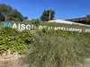
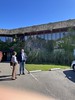
What time is it? If the time and day are right, this sundial will tell you: SOLSTICE. Only then will the Sun be located just right for sunlight to stream through openings and spell out the term for the longest and shortest days of the year. And that happened last week and twice each year.
The sundial was constructed by Jean Salins in 1980 and is situated at the Ecole Supérieure des Mines de Paris in Valbonne Sophia Antipolis of south-eastern France. On two other days of the year, watchers of this sundial might get to see it produce another word: EQUINOXE.
With thanks to Jean-Marc Mari for allowing use of the photo and Judy Robinson for suggesting it.
You may be viewing yesterday's version of this page. To see the most up to date information please register for a free account.
Do not use the above information on other web sites or publications without permission of the contributor.
davidmorgan has found this location on Google Street View:
Nearby Images from Flickr


The above images may not be of the site on this page, but were taken nearby. They are loaded from Flickr so please click on them for image credits.
Click here to see more info for this site
Nearby sites
Click here to view sites on an interactive map of the areaKey: Red: member's photo, Blue: 3rd party photo, Yellow: other image, Green: no photo - please go there and take one, Grey: site destroyed
Download sites to:
KML (Google Earth)
GPX (GPS waypoints)
CSV (Garmin/Navman)
CSV (Excel)
To unlock full downloads you need to sign up as a Contributory Member. Otherwise downloads are limited to 50 sites.
Turn off the page maps and other distractions
Nearby sites listing. In the following links * = Image available
3.0km SSE 166° Font de Cine Court Tomb
4.5km NNE 15° Grotte du Clos Cave or Rock Shelter
4.7km WSW 251° Aven des Breguieres Cave or Rock Shelter
4.8km NW 322° Aven de la Mort Lambert Court Tomb
6.5km NNW 337° Dolmen de Clamarquier Burial Chamber or Dolmen
7.9km NNE 22° Grotte Bianchi Cave or Rock Shelter
8.2km NNW 346° Dolmen des Peyraoutes* Burial Chamber or Dolmen
8.3km NNW 329° Le Castellaras Burial Chamber or Dolmen
8.6km WNW 298° Tumulus de Saint-Christophe Artificial Mound
8.9km NW 317° La pierre Haute Dolmen Burial Chamber or Dolmen
10.1km NE 42° Saint-Veran Grotte Cave or Rock Shelter
10.4km N 1° Baume Obscure Grotte Sepulcrale Cave or Rock Shelter
10.5km WNW 282° Grotte de Peymeinade Cave or Rock Shelter
11.2km N 10° Grotte Sepulcrale de L'Aigle Cave or Rock Shelter
11.4km WNW 294° The Museum of Provençal Art and History Museum
11.5km NNW 329° Grotte de la Saree Cave or Rock Shelter
12.1km NNW 330° Grotte du Revest Cave or Rock Shelter
12.3km NW 324° Tumulus de la Saree Artificial Mound
12.7km NNW 342° Dolmen de Cantracier Burial Chamber or Dolmen
13.1km N 2° Le Caire Tumulus Artificial Mound
13.9km NNE 14° Grotte Sepulcrale Chabert Cave or Rock Shelter
13.9km WNW 290° Collet de Stramouse Dolmen Burial Chamber or Dolmen
14.1km NNE 19° Grotte Sepulcrale Des Perles Cave or Rock Shelter
14.1km NNE 20° Tumuli du Plan des Noves Artificial Mound
14.6km NNE 21° Grotte Sepulcrale de L'Ibis Cave or Rock Shelter
View more nearby sites and additional images


 We would like to know more about this location. Please feel free to add a brief description and any relevant information in your own language.
 Wir möchten mehr über diese Stätte erfahren. Bitte zögern Sie nicht, eine kurze Beschreibung und relevante Informationen in Deutsch hinzuzufügen.
 Nous aimerions en savoir encore un peu sur les lieux. S'il vous plaît n'hesitez pas à ajouter une courte description et tous les renseignements pertinents dans votre propre langue.
 Quisieramos informarnos un poco más de las lugares. No dude en añadir una breve descripción y otros datos relevantes en su propio idioma.