


<< Our Photo Pages >> Bilstein - Rock Outcrop in Germany in North Rhine-Westphalia
Submitted by Harald_Platta on Friday, 22 April 2016 Page Views: 1170
Natural PlacesSite Name: Bilstein Alternative Name: Bildstein, Bilderstein, KanzelCountry: Germany
NOTE: This site is 1.43 km away from the location you searched for.
Land: North Rhine-Westphalia Type: Rock Outcrop
Nearest Town: Essen
Latitude: 51.365977N Longitude: 6.955345E
Condition:
| 5 | Perfect |
| 4 | Almost Perfect |
| 3 | Reasonable but with some damage |
| 2 | Ruined but still recognisable as an ancient site |
| 1 | Pretty much destroyed, possibly visible as crop marks |
| 0 | No data. |
| -1 | Completely destroyed |
| 5 | Superb |
| 4 | Good |
| 3 | Ordinary |
| 2 | Not Good |
| 1 | Awful |
| 0 | No data. |
| 5 | Can be driven to, probably with disabled access |
| 4 | Short walk on a footpath |
| 3 | Requiring a bit more of a walk |
| 2 | A long walk |
| 1 | In the middle of nowhere, a nightmare to find |
| 0 | No data. |
| 5 | co-ordinates taken by GPS or official recorded co-ordinates |
| 4 | co-ordinates scaled from a detailed map |
| 3 | co-ordinates scaled from a bad map |
| 2 | co-ordinates of the nearest village |
| 1 | co-ordinates of the nearest town |
| 0 | no data |
Internal Links:
External Links:
")
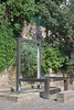
Today, much of the original rock outcrop has been removed. According to local legends, the original Bilstein had reminded the ancient people of a giant`s head. The site was used as a sanctuary by the Germainc tribe of the Chatti. They worshiped the fertility goddess Ostara, who is now the namesake of the festival of Easter.
Literature:
[01] Sondermann, D.: Die Kanzel. In: Ruhrsagen. Von Ruhrort bis Ruhrkopf (2005).
You may be viewing yesterday's version of this page. To see the most up to date information please register for a free account.
")
")
Do not use the above information on other web sites or publications without permission of the contributor.
Nearby Images from Flickr
The above images may not be of the site on this page, but were taken nearby. They are loaded from Flickr so please click on them for image credits.
Click here to see more info for this site
Nearby sites
Click here to view sites on an interactive map of the areaKey: Red: member's photo, Blue: 3rd party photo, Yellow: other image, Green: no photo - please go there and take one, Grey: site destroyed
Download sites to:
KML (Google Earth)
GPX (GPS waypoints)
CSV (Garmin/Navman)
CSV (Excel)
To unlock full downloads you need to sign up as a Contributory Member. Otherwise downloads are limited to 50 sites.
Turn off the page maps and other distractions
Nearby sites listing. In the following links * = Image available
3.1km ENE 70° Alteburg (Essen)* Hillfort
3.9km ENE 62° Herrenburg (Essen)* Hillfort
4.0km ENE 62° Quellheiligtum Klemensborn* Holy Well or Sacred Spring
4.1km N 356° Gräberfeld Lilienthalstraße* Barrow Cemetery
4.4km N 7° Galgenhügel Schuir* Artificial Mound
5.0km N 353° Dellberg* Artificial Mound
5.6km NW 324° Summstein Holthausen* Modern Stone Circle etc
6.3km ESE 119° Summstein Herminghauspark* Modern Stone Circle etc
8.0km NE 47° Summstein Schellenberg* Modern Stone Circle etc
8.5km ENE 78° Kupferdreh Steinkiste* Cist
9.0km NW 322° Summstein im Stadthallengarten* Modern Stone Circle etc
9.3km ENE 72° Mineralien-Museum Essen-Kupferdreh* Museum
9.4km NW 304° Hünengrab Uhlenhorst* Modern Stone Circle etc
11.0km N 352° Borbecke Quelle* Holy Well or Sacred Spring
11.8km WNW 301° Heiliger Brunnen im Duisburger Wald* Holy Well or Sacred Spring
12.5km NW 309° In der Monning* Barrow Cemetery
12.9km WNW 286° In den Rehwiesen* Barrow Cemetery
13.0km ENE 77° Heiliger Spring (Hattingen)* Holy Well or Sacred Spring
13.2km WNW 294° Wedau* Barrow Cemetery
13.4km ENE 57° Ruhrkämpfer-Denkmal* Modern Stone Circle etc
13.5km ENE 56° Vryburg* Hillfort
13.5km NW 308° Marienborn (Duisburg)* Holy Well or Sacred Spring
13.5km ENE 76° Heidenstein (Hattingen)* Natural Stone / Erratic / Other Natural Feature
13.8km NW 308° Wallburg Kaiserberg* Hillfort
13.9km E 80° Isenberg Höhlung* Cave or Rock Shelter
View more nearby sites and additional images


 We would like to know more about this location. Please feel free to add a brief description and any relevant information in your own language.
 Wir möchten mehr über diese Stätte erfahren. Bitte zögern Sie nicht, eine kurze Beschreibung und relevante Informationen in Deutsch hinzuzufügen.
 Nous aimerions en savoir encore un peu sur les lieux. S'il vous plaît n'hesitez pas à ajouter une courte description et tous les renseignements pertinents dans votre propre langue.
 Quisieramos informarnos un poco más de las lugares. No dude en añadir una breve descripción y otros datos relevantes en su propio idioma.